Schedule 1
(Regulation 4(1))
Immovable
property transferred on transfer date
Part 1
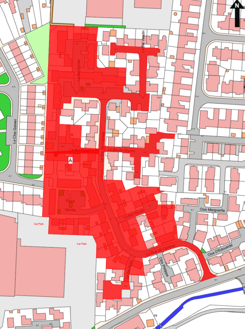
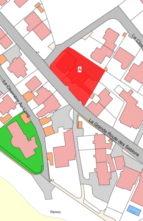
Bashfords
(Comprising: Le Bel Perrée, Place
Nicolle, Place Le Gallais, Le Bel Gaudin, Le Bel Mallet and the
Development spine road La Rue de Carteret)
(1) The
remainder of the Property known as Bashfords (“the Property”), as shown on the
Plan in this Part entititled “Bashfords”, to which the public has right by the Contracts
of Purchase dated –
(a) 28th December 1979
(PR 711/172); and
(b) 17th September 1982
(PR 749/255),
(“Contracts of
Purchase”).
(2) The
boundaries of the Property and all rights attaching thereto are as set out in
the Contracts of Purchase and in the following contracts –
(a) the contract of exchange
and counter exchange dated 24th February 1984 (PR 775/225);
(b) the contract of gift cession
and transfer of the party ownership of a wall dated 8th July 1983
(PR 764/488); and
(c) the contracts of sale by
the public of the following Properties –
(i) 3 Bel Gaudin dated 3rd June 2011
(PR 1280/338),
(ii) 6 Bel Gaudin dated 25th
April 2014 (PR 1329/672),
(iii) 26 Rue de Carteret dated
23rd October 2009 (PR 1256/675),
(iv) 14 La Rue de
Carteret dated 28th October 1983 (PR 769/678),
(v) 15 La Rue de Carteret dated 25th
November 1983 (PR 771/268),
(vi) 16 La Rue de
Carteret dated 4th November 1983 (PR 770/272),
(vii) 17 La Rue de Carteret
dated 28th October 1983 (PR 770/16),
(viii) 18 La Rue de Carteret
dated 28th October 1983 (PR 770/23),
(ix) 19 La Rue de
Carteret dated 2nd December 1982 (PR 771/672),
(x) 20 La Rue de Carteret dated 16th
December 1983 (PR 773/35),
(xi) 1 Le Bel Vaudin
dated 1st July 1983 (PR 764/271),
(xii) 2 Le Bel Vaudin dated
15th July 1983 (PR 765/1),
(xiii) 3 Le Bel Vaudin dated
8th July 1983 (PR 764/558),
(xiv) 4 Le Bel Vaudin dated
15th July 1983 (PR 765/190),
(xv) 5 Le Bel Vaudin dated
15th July 1983 (PR 765/40),
(xvi) 6 Le Bel Vaudin dated
15th July 1983 (PR 765/106),
(xvii) 7 Le Bel Vaudin dated
22nd July 1983 (PR 765/274),
(xviii) 8 Le Bel Vaudin
dated 15th July 1983 (PR 765/131),
(xix) 9
Le Bel Vaudin dated 8th July 1983 (PR 764/492),
(xx) 10 Le Bel Vaudin
dated 15th July 1983 (PR 765/68),
(xxi) 11 Le Bel Vaudin dated
15th July 1983 (PR 765/151),
(xxii) 1 Le Bel Estur dated
24th February 1984 (PR 775/331),
(xxiii) 2 Le Bel Estur dated 2nd
March 1984 (PR 775/669),
(xxiv) 3 Le Bel Estur
dated 12th August 1983 (PR 766/283),
(xxv) 4
Le Bel Estur dated 19th August 1983 (PR 766/673),
(xxvi) 5 Le Bel Estur dated
22nd July 1983 (PR 765/417),
(xxvii) 6 Le Bel Estur
dated 29th July 1983 (PR 765/629),
(xxviii) 7
Le Bel Estur dated 29th July 1983 (PR 765/623),
(xxix) 1
Le Bel de Gruchy dated 2nd December 1983 (PR 772/1),
(xxx) 2
Le Bel de Gruchy dated 9th December 1983 (PR 772/143),
(xxxi) 3 Le Bel de Gruchy dated
2nd December 1983 (PR 771/647),
(xxxii) 4 Le Bel de
Gruchy dated 3rd February 1984 (PR 774/268),
(xxxiii) 5
Le Bel de Gruchy dated 13th January 1984 (PR 773/500),
(xxxiv) 6
Le Bel de Gruchy dated 6th January 1984 (PR 773/317),
(xxxv) 7
Le Bel de Gruchy dated 16th December 1983 (PR 772/421),
(xxxvi) 8
Le Bel de Gruchy dated 9th December 1983 (PR 772/118),
(xxxvii) 1
Place Le Gallais dated 28th October 1983 (PR 769/686),
(xxxviii) 2
Place Le Gallais dated 18th November 1983 (PR 771/39),
(xxxix) 3
Place Le Gallais dated 28th October 1983 (PR 770/77),
(xl) 20
Place Le Gallais dated 15th July 1983 (PR 765/62),
(xli) 21 Place Le Gallais
dated 15th July 1983 (PR 765/183),
(xlii) 22 Place Le Gallais
dated 28th October 1983 (PR 769/658),
(xliii) 23 Place Le Gallais
dated 18th November 1983 (PR 771/90),
(xliv) 24 Place Le Gallais dated
9th December 1983 (PR 772/187), and
(xlv) 25 Place Le Gallais
dated 11th November 1983 (PR 770/546).
NOTE:
The
public administers and maintains as public sewers the main foul and surface
water sewers in the roads and parking areas within the Property including Clos
d’Edouarde, Clos Marguerite, Clos Philippe, Le Bel Estur, Le Bel
Gaudin, Place Nicolle, Le Bel Mallet, Le Bel de Gruchy, Le Bel
Perrée and Le Bel Vaudin.
The public foul sewer in Clos
Marguerite extends to the north and drains private foul sewers serving
La Maison des Pres and Le Petit Pres. The public surface water sewer
in Clos Philippe extends south across the garden of No. 3 Le Bel
Estur and into La Rue des Pres. Public foul and surface water sewers
extend south across the garden of No. 5 Le Bel Estur and into
La Rue des Pres. A public foul sewer rising main enters La Place
Nicolle from the south, from the supermarket site, between Nos. 1 and 2
and then heads west back into the supermarket car park along with the public
foul and surface water sewers between Nos. 3 and 4. Public foul and
surface water sewers extend west from Le Bel Perrée between Nos. 7, 8
and 9 and No. 10 to drain other sewers to the rear of those properties.
Public foul and surface water sewers extend north from Le Bel Perrée
between Nos. 3, 4 and 5 and No. 6 to drain industrial properties on
Longueville Road.
The public does not maintain or
administer any branch connections from these public sewers to any of the
properties forming part of the Property or any road drainage system in the
roads forming part of the Property.
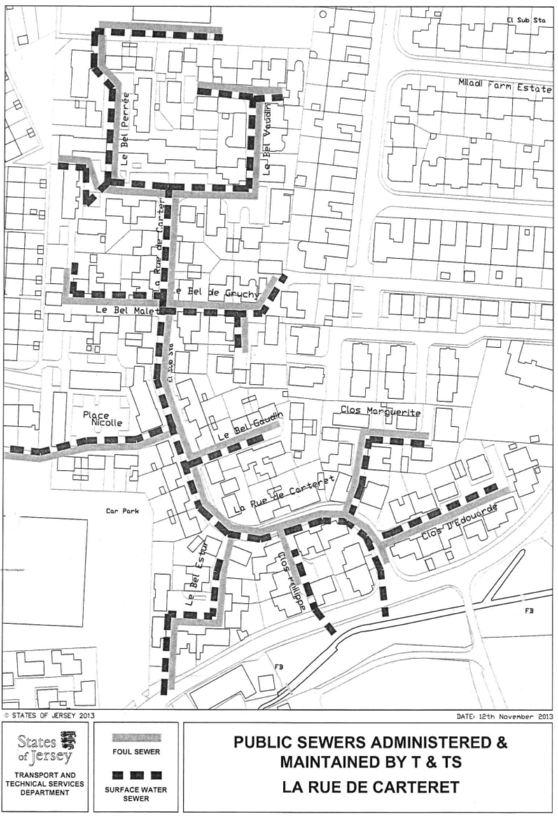
The routes of the public sewers
described above are as shown on the plan in this Part entitled “Public Sewers
administered and maintained by T&TS La Rue de Carteret”.
The Property is situate in the
Parish of St. Saviour in the Vingtaine de la Petite Longueville and has
the UPRN 69386464.
Bashfords
Part 2
Le Clos
Gosset and Gordon Le Breton Close
(1) The
properties known as Le Clos Gosset and Gordon Le Breton Close (“the
Properties”), as shown on the Plan in this Part entitled “Le Clos Gosset
and Gordon Le Breton Close”, to which the public has right by the Contracts
of Purchase dated –
(a) 29th July 1966
(PR 518/89);
(b) 13th January 1967
(PR 525/19);
(c) 13th September 1985
(PR 800/248);
(d) 24th August 1990
(PR 887/259);
(e) 9th November 1990
(PR 890/626); and
(f) 10th April 1992
(PR 916/20),
(“Contracts of Purchase”).
(2) The
boundaries of the Properties and all rights attaching thereto are as set out in
the Contracts of Purchase and in sub-paragraphs (3) and (4).
(3) The
boundaries of the Property called Ruxley (retained by the public and to which
the Public has right by contract of purchase dated 8th November 2002 (PR 1145/452))
towards the Properties are the granite walls of the North-West, South-West and
South-East and of the South-Western gable of the garage forming part of Ruxley,
and such boundaries are party owned between the parties.
(4) The
boundary line on the remainder of the South-Western side of Ruxley to the
North-West of the garage is an imaginary straight line drawn from the centre of
the North-Western end of the South-Western gable of the garage in a
North-Westerly direction until reaching the main road called Longueville Road.
NOTE:
The public administers and
maintains as public sewers both foul and surface water sewers that enter the
Properties from the supermarket site to the south and under the garage of
No. 35 Le Clos Gosset and into the roads within the Properties. The
public sewers split at this point with foul and surface water sewers heading in
a westerly direction as far as No. 41 and No. 47 Le Clos Gosset
respectively. Public foul and surface water sewers also extend to the north and
follow the road within the Properties around to Longueville Road where the foul
sewer terminates to the south of No. 10 Le Clos Gosset and the
surface water sewer adjacent to No. 81 Le Clos Gosset.
A single public surface water pipe
extends from adjacent to No. 21 Le Clos Gosset to the north as far as
the parking area between Nos. 14 and 15 Le Clos Gosset. A public foul
branch sewer from the public foul sewer in Longueville Road heads south to a
point adjacent to No. 82 Le Clos Gosset then heads in an easterly
direction crossing under the gardens of Nos. 8 and 7 Le Clos Gosset,
across the parking area to the eastern boundary of the Properties where it
drains private properties to the north-east on Longueville Road.
A public foul sewage pumping main
is also present and follows the run of the public sewers from the supermarket
car park to the south to the vehicle access onto Longueville Road.
The public does not maintain or
administer any branch connections from these public sewers to any of the
properties forming part of the Properties or any road drainage system in the
roads forming part of the Properties.
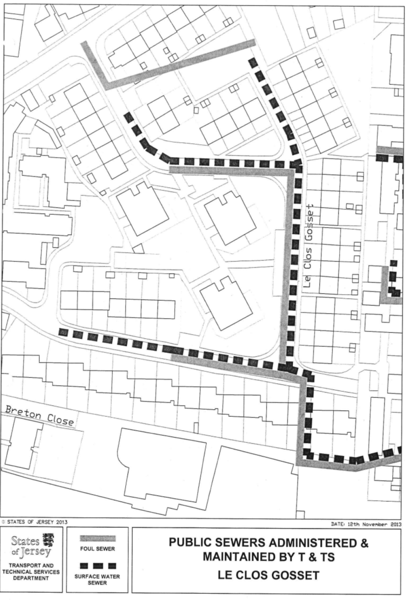
The routes of the public sewers
described above are as shown on the plan in this Part entitled “Public Sewers
administered and maintained by T&TS Le Clos Gosset”.
The properties are situate in the
Parish of St. Saviour in the Vingtaine de la Petite Longueville and have
the UPRN 69408196 and 69386639.
Le Clos Gosset and Gordon Le Breton Close
Part 3
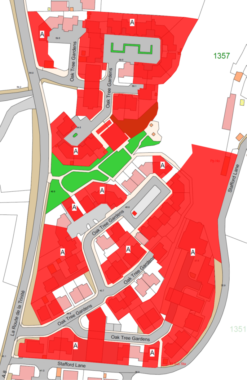
Oak
Tree Gardens
(1) The
remainder of the property known as Oak Tree Gardens (“the Property”), as shown
on the Plan in this Part entitled “Oak Tree Gardens”, to which the public has right
by contract of purchase dated 6th September 1947 (PR 446B/144)
(“Contract of Purchase”).
(2) The
boundaries of the Property and all rights attaching thereto are as set out in –
(a) the Contract of Purchase;
(b) the Act of Court
registering the constitution of the Oak Tree Gardens Property Owners
Association dated 12th December 2008 (PR 1244/859);
(c) the contracts of –
(i) sale, cession and transfer of rights by
the public dated 20th December 1985 (PR 805/379),
(ii) 99 year lease of a
substation and section pillar and Cession of Wayleave Rights by the public to
The Jersey Electricity Company Limited dated 21st November 2003
(PR 1162/846),
(iii) sale, cession and
transfer of rights by the public dated 25th February 2005
(PR 1180/459),
(iv) sale, cession and
transfer of rights by the public dated 5th August 2005 (PR 1187/887),
and
(v) gift, cession and transfer by the public to
Oak Tree Gardens Property Owners Association dated 2nd January 2009
(PR 1245/248); and
(d) the contracts of sale by
the public of the following Properties –
(i) No. 2 Oak Tree Gardens dated 2nd
January 2009 (PR 1245/298),
(ii) No. 3 Oak Tree
Gardens dated 2nd January 2009 (PR 1245/288),
(iii) No. 37 Oak Tree
Gardens dated 3rd April 2009 (PR 1248/688),
(iv) No. 39 Oak Tree
Gardens dated 2nd January 2009 (PR 1245/279),
(v) No. 15 Oak Tree Gardens
dated 16th January 2009 (PR 1245/492),
(vi) No. 38 Oak Tree
Gardens dated 9th January 2009 (PR 1245/424),
(vii) No. 27 Oak Tree
Gardens dated 6th March 2009 (PR 1247/31),
(viii) No. 47 Oak Tree
Gardens dated 4th September 2009 (PR 1254/772),
(ix) No. 53 Oak Tree
Gardens dated 4th November 2011 (PR 1287/99),
(x) No. 78 Oak Tree Gardens dated 29th
November 2013 (PR 1322/806),
(xi) No. 54 Oak Tree
Gardens dated 6th December 2013 (PR 1323/210),
(xii) No. 25 Oak Tree
Gardens dated 18th October 2013 (PR 1320/831),
(xiii) No. 26 Oak Tree
Gardens dated 14th February 2014 (PR 1326/483), and
(xiv) No. 32 Rose Court
dated 7th February 2014 (PR 1326/116).
NOTE:
The Property is situate in the
Parish of St. Helier, Vingtaine du Haut du Mont au Prêtre and has the
UPRN 69407254.
Oak Tree Gardens
Part 4
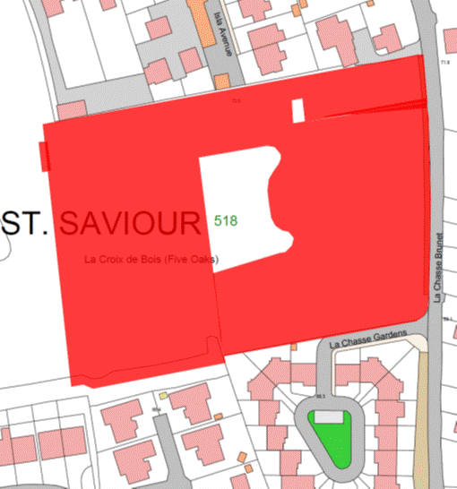
Grasett
Park
(1) The
remainder of the property known as Grasett Park (“the Property”), as shown on
the Plan in this Part entitled “Grasett Park”, to which the public has right by
the Contracts of Purchase dated –
(a) 30th November 1946
(PR 444B/200); and
(b) 17th April 1948
(PR 448B/75),
(“Contracts of Purchase”).
(2) The
boundaries of the Property and all rights attaching thereto are as set out in –
(a) the Contracts of
Purchase;
(b) the Act of Court
registering the constitution of the Grasett Park Property Owners Association
dated 15th August 2008 (PR 1240/543);
(c) the following
contracts –
(i) the contract of transaction dated 8th
February 1947 (PR 445A/59),
(ii) the contracts of Lease
and Wayleave Rights by the public to The Jersey Electricity Company Limited
dated 1st February 2002 (PR 1131/241) and to Jersey Electricity PLC
dated 29th July 2011 (PR 1283/34), and
(iii) the contract of gift
cession and transfer dated 15th August 2008 by the public to Grasett Park
Property Owners Association (PR 1240/414); and
(d) the following contracts
of sale of properties in Grasett Park by the public –
(i) No. 1 dated 15th July 2011
(PR 1281/849),
(ii) No. 5 dated 4th April 2014
(PR 1329/144),
(iii) No. 6 dated 26th
September 2008 (PR 1241/870),
(iv) No. 9 dated 3rd
October 2008 (PR 1242/167),
(v) No. 14 dated 29th November 2013
(PR 1322/857),
(vi) No. 16 dated 26th February 2010
(PR 1260/967),
(vii) No. 17 dated 3rd
May 2013 (PR 1311/735),
(viii) No. 18 dated 3rd
April 2009 (PR 1248/380),
(ix) No. 26 dated 29th
November 2013 (PR 1322/869),
(x) No. 27 dated 24th February 2012
(PR 1291/946),
(xi) No. 33 dated 28th
August 2009 (PR 1254/511),
(xii) No. 42
dated 19th June 2009 (PR 1251/237),
(xiii) No. 43 dated 5th
July 2013 (PR 1314/959),
(xiv) No. 48 dated 16th
January 2009 (PR 1245/601),
(xv) No. 52 dated 14th
May 2010 (PR 1263/723),
(xvi) No. 53 dated 12th
September 2008 (PR 1241/371),
(xvii) No. 59 dated 28th
October 2011 (PR 1286/989),
(xviii) No. 63 dated
21st May 2010 (PR 1263/902),
(xix) No. 69 dated 19th
June 2009 (PR 1251/417),
(xx) No. 70 dated 24th
April 2009 (PR 1249/448),
(xxi) No. 71 dated 19th
July 2013 (PR 1315/807),
(xxii) No. 74 dated 18th
July 2008 (PR 1239/150),
(xxiii) No. 80 dated
8th February 2008 (PR 1232/49),
(xxiv) No. 2
Grasett Park dated 31st January 2014 (PR 1325/404), and
(xxv) No. 54 Grasett Park
dated 28th February 2014 (PR 1327/258).
NOTE:
The Property is situate in the
Parish of St. Saviour in the Vingtaine de Petite Longueville and has the
UPRN 69407943.
Grasett Park
Part 5
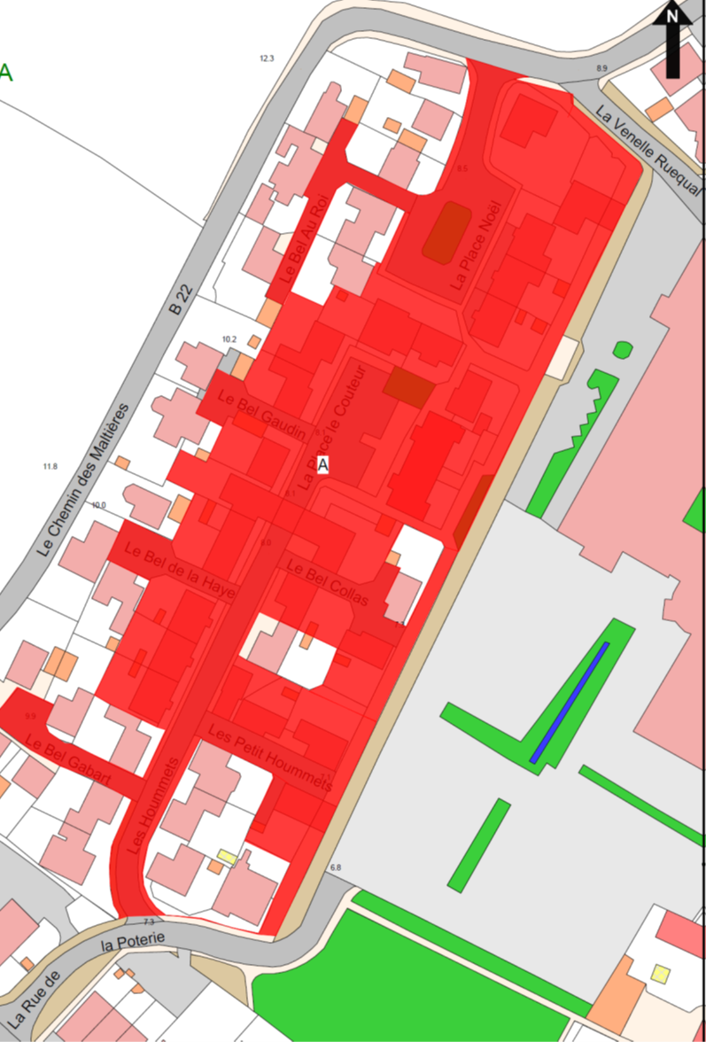
Gorey
Village Phase 1
(1) The
remainder of the property known as Gorey Village Phase 1 (“the Property”), as
shown on the Plan in this Part entitled “Gorey Village Phase 1”, to which
the public has right by the contracts of purchase dated –
(a) 30th November 1973
(PR 619/581);
(b) 1st July 1977
(PR 672/156);
(c) 13th October 1978
(PR 695/228);
(d) 10th November 1978 (PR 696/194);
and
(e) contract of exchange and
counter exchange dated 5th November 2010 (PR 1269/24),
(“Contracts of Purchase”).
(2) The
boundaries of the Property and all rights attaching thereto are as set out in
the Contracts of Purchase and in the contracts of sale of the following
Properties by the public –
(a) 1 La Place Noel
dated 25th February 1983 (PR 758/128);
(b) 6 La Place Noel
dated 24th December 1982 (PR 755/297);
(c) 7 La Place Noel
dated 26th November 1982 (PR 753/310);
(d) 8 La Place Noel dated 17th
December 1982 (PR 755/29);
(e) 9 La Place Noel
dated 7th January 1983 (PR 755/691);
(f) 10 La Place Noel
dated 26th November 1982 (PR 753/337);
(g) 1 Le Bel au Roi
dated 10th December 1982 (PR 754/266);
(h) 2 Le Bel au Roi
dated 18th February 1983 (PR 757/616);
(i) 3 Le Bel au Roi
dated 24th December 1982 (PR 755/384);
(j) 1 La Place le
Couteur dated 15th June 2012 (PR 1297/90);
(k) 1 Le Bel Gaudin
dated 2nd July 1982 (PR 746/183);
(l) 2 Le Bel Gaudin
dated 9th July 1982 (PR 746/404);
(m) 1 Le Bel de la Haye
dated 30th April 1982 (PR 743/25);
(n) 2 Le Bel de la Haye
dated 7th May 1982 (PR 743/182);
(o) 3 Le Bel de la Haye
dated 7th May 1982 (PR 743/273);
(p) 1 Le Bel Gabart
dated 5th March 1982 (PR 740/271);
(q) 2 Le Bel Gabart
dated 5th March 1982 (PR 740/315);
(r) 3 Le Bel Gabart
dated 5th March 1982 (PR 740/360);
(s) 4 Le Bel Gabart
dated 12th March 1982 (PR 740/445);
(t) 5 Le Bel Gabart
dated 5th March 1982 (PR 740/375);
(u) 1 Le Bel Collas
dated 23rd May 2008 (PR 1236/780);
(v) 1 La Rue de la Poterie
dated 5th March 1982 (PR 740/199);
(w) 1 Les Hoummets dated
5th March 1982 (PR 740/252);
(x) 2 Les Hoummets dated
5th March 1982 (PR 740/239);
(y) 3 Les Hoummets dated
5th March 1982 (PR 740/328);
(z) 11 Les Hoummets
dated 23rd May 2008 (PR 1236/724);
(aa) 12 Les Hoummets dated
5th March 1982 (PR 740/305);
(ab) 13 Les Hoummets dated
5th March 1982 (PR 740/190);
(ac) 14 Les Hoummets dated
5th March 1982 (PR 740/222); and
(ad) 2 Le Bel Collas dated
6th December 2013 (PR 1323/145).
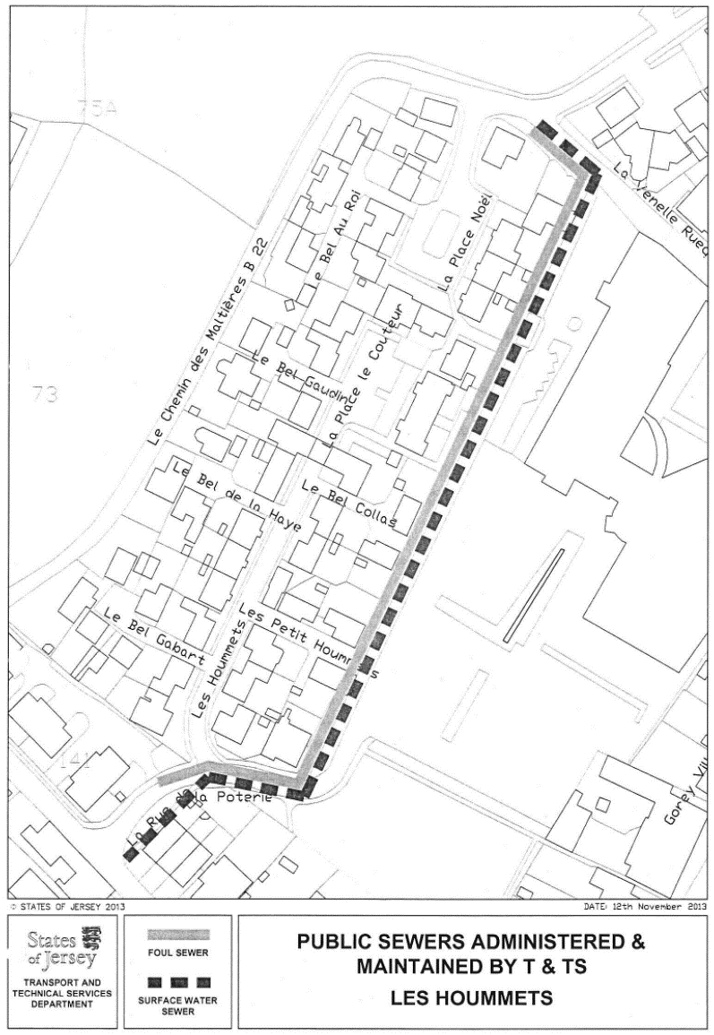
NOTE:
The public administers and
maintains as public sewers both foul and surface water sewers in La Rue de
la Poterie that extend along the south-east face of the Property under the
pedestrian access way known as La Venelle Ruequal and then extend to the
north-west into Le Chemin des Maltieres.
The public does not maintain or
administer any sewers or road drainage systems within the Property or any
connections to the public sewers in La Rue de la Poterie or under the
pedestrian access way.
The routes of the public sewers described
above are as shown on the plan in this Part entitled “Public Sewers
administered and maintained by T&TS Les Hoummets”.
The Property is situate in the
Parish of Grouville in the Vingtaine des Marais and has the UPRN 69386641.
Gorey Village Phase 1
Part 6
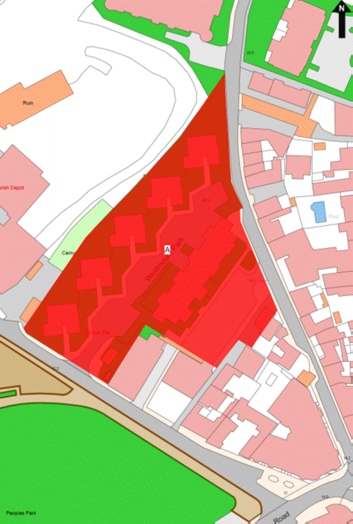
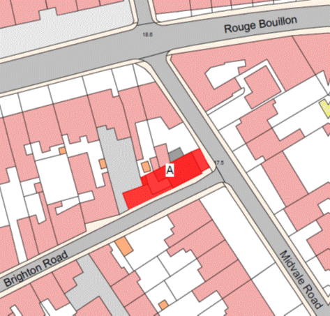
Westmount
Park, Old St. John’s Court and 17 Old St. John’s Road
(1) The
properties known as Westmount Park, Old St. John’s Court and 17 Old St. John’s
Road forming one corpus fundi (“the
Property”), as shown on the Plan in this Part entitled “Westmount Park, Old St. John’s
Court and 17 Old St. John’s Road”, to which the public has right by
the –
(a) contracts of purchase dated –
(i) 24th August 1832 (PR 155/45),
(ii) 6th December 1963
(PR 482C/35),
(iii) 4th December 1964
(PR 495/511),
(iv) 19th November 1965
(PR 507/481),
(v) 26th November 1965 (PR 508/45),
(vi) 27th May 1966
(PR 515/165),
(vii) 1st November 1968
(PR 550/484),
(viii) 7th February 1969
(PR 553/514),
(ix) 3rd November 1972
(exchange and counter-exchange) (PR 604/29),
(x) 1st July 1983 (exchange and
counter-exchange) (PR 764/217); and
(b) by way of compulsory
purchase under Compulsory
Purchase of Land (Procedure) (Jersey) Law 1961 by 3 Acts of the Royal
Court dated 22nd May 1970 (PR 568/577) (PR 568/581); (PR 568/583)
(“Acts of the Royal Court”),
(“Contracts of Purchase
and Acts of the Royal Court”).
(2) The
boundaries of the Property and all rights attaching thereto are as set out in
the Contracts of Purchase, the Acts of the Royal Court and in the following
contracts –
(a) sale by the public dated
4th November 1961 (PR 478A/176); and
(b) Lease and Cession of
Wayleave Rights by the public to The Jersey Electricity Company Limited dated
27th August 1971 (PR 586/338).
NOTE:
The Property is situate in the
Parish of St. Helier in the Vingtaine de Rouge Bouillon having the
UPRN 69137567 and 69130536 (No. 17).
Westmount Park, Old St. John’s Court and 17 Old St. John’s
Road
Part 7
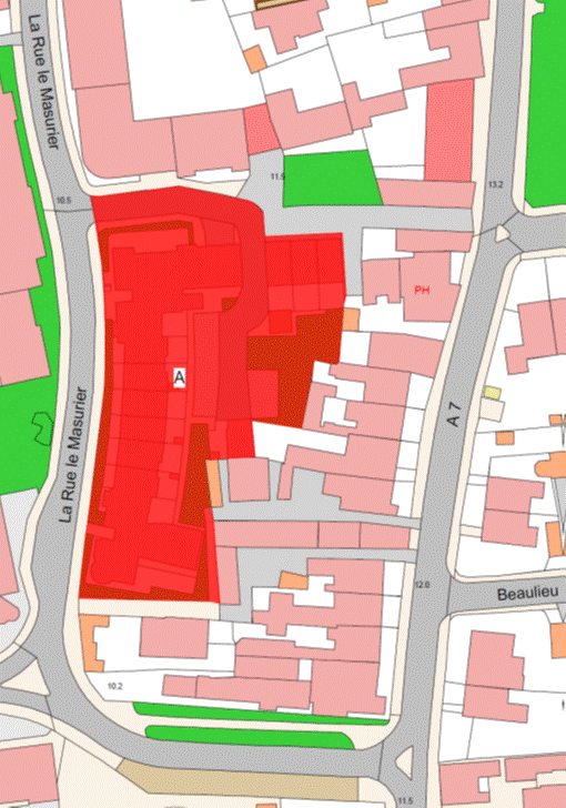
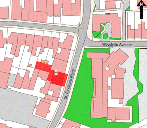
Salisbury
Crescent
(1) The
property known as Salisbury Crescent (“the Property”), as shown on the Plan in
this Part entitled “Salisbury Crescent”, to which the public has right by the
contracts of purchase dated –
(a) 14th November 1997
(PR 1042/520);
(b) 14th November 1997
(PR 1042/486);
(c) 14th November 1997(PR 1042/501);
(d) 6th July 1979
(PR 704/686);
(e) 20th January 1989
(PR 860/200);
(f) 27th February 2009
(PR 1246/772); and
(g) 6th March 2009
(PR 1247/39),
(“Contracts of Purchase”).
(2) The
boundaries of the Property and all rights attaching thereto are as set out in
the Contracts of Purchase and in the contract of sale by the public dated 12th
November 2004 (PR 1176/922).
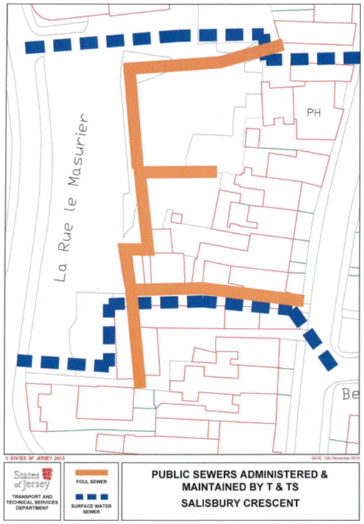
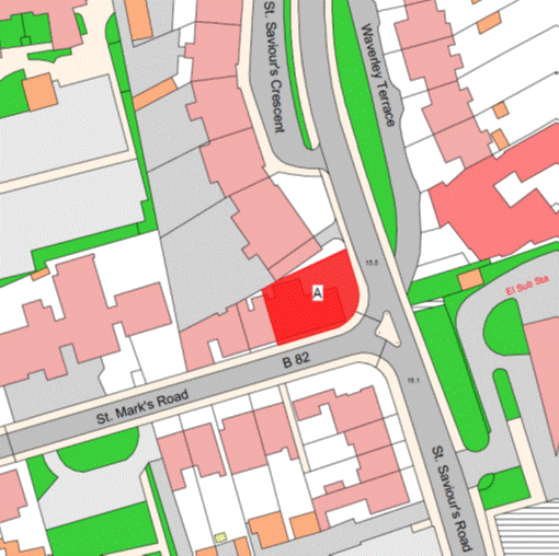
NOTE:
The public administers and
maintains as a public sewer a foul sewer that lies to the east of the main block
of the Property and drains properties on St. Saviour’s Road. The head of
the public foul sewer lies between Norwood Villas and Wellington Stores and
drains in a westerly direction before heading south under the access road for
the Property where it then drains in an easterly direction under a private lane
between Nos. 98 and 99 St. Saviour’s Road and connects to the public
main trunk sewer in that road. An extension from the western end of the private
lane to the south drains Nos. 94 to 97 St. Saviour’s Road and other
properties to the west.
The Department also administers
and maintains as a public sewer a surface water sewer in the private lane
between Nos. 98 and 99 St. Saviour’s Road that flows to the west and
into the Property turning south and then west again to connect to the larger
public surface water sewer in La Rue le Masurier along the southern
boundary of the Property.
The Department does not maintain
or administer any branch connections from these public sewers to the Property
or any road drainage system in the roads or parking areas forming parts of the
Property.
The routes of the public sewers
described above are as shown on the plan in this Part entitled “Public Sewers
administered and maintained by T&TS Salisbury Crescent”.
The Property is situate in the
Parish of St. Helier in the Vingtaine of Haut de la Ville and has the
UPRN 69380451.
Salisbury Crescent
Part 8
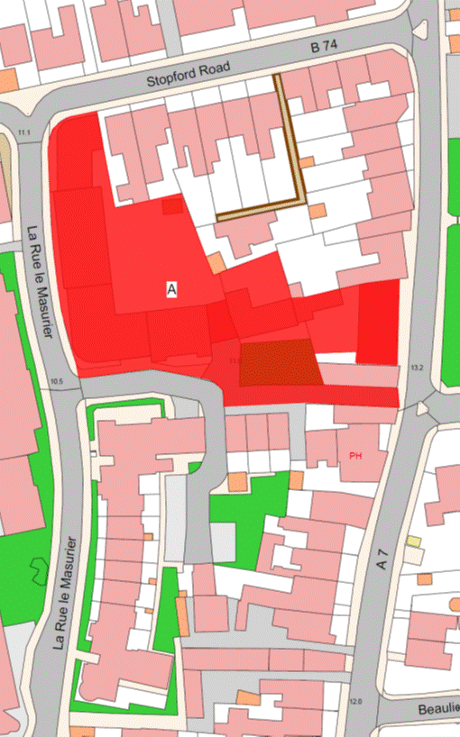
Westley
Court (Westley Lodge and Westley Cottage)
(1) The
Property known as Westley Court (“the Property”), as shown on the Plan in this
Part entitled “Westley Court (Westley Lodge and Westley Cottage)”, to which the
public has right by –
(a) the Contracts of Purchase
dated –
(i) 18th November 1977 (PR 678/179),
(ii) 28th September 1979
(PR 707/357),
(iii) 29th February 1980
(PR 713/326),
(iv) 10th April 1981
(PR 727/484),
(v) 5th December 1986 (PR 823/168),
(vi) 13th September 1991
(PR 905/538),
(“Contracts of Purchase”)
and
(b) by Compulsory Purchase from unknown owners under Compulsory Purchase of
Land (Procedure) (Jersey) Law 1961 by Act of the Royal Court dated 7th
March 2003 (PR 1150/526), (“Act of the Royal Court”).
(2) The
boundaries of the Property and all rights attaching thereto are as set out in
the Contracts of Purchase and the Act of the Royal Court.
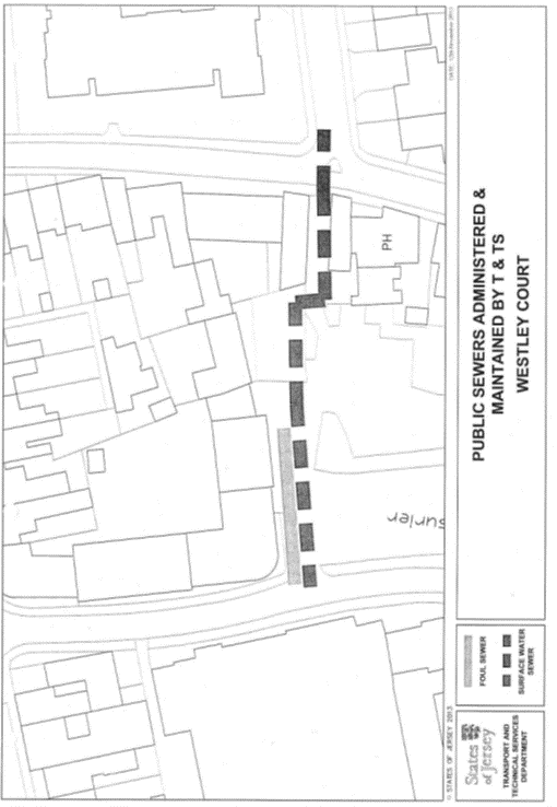
NOTE:
The public administers and
maintains as public sewers both foul and surface water sewers that lie in the
access road forming part of the Property. The public foul sewer extends to the
east from La Rue le Masurier for approximately 30 metres and drains
the Property. The public surface water sewer runs parallel to the foul sewer
and extends through to St. Saviour’s Road.
The Department does not maintain or
administer any branch connections from these public sewers to the Property or
any road drainage system in the access road forming part of the Property.
The routes of the public sewers
described above are as shown on the plan in this Part entitled “Public Sewers
administered and maintained by T&TS Westley Court”.
The Property is situate in the
Parish of St. Saviour in the Vingtaine de Sous l’Eglise and has the
UPRN 69002689 and 69401219 (Lodge).
Westley Court (Westley Lodge and Westley Cottage)
Part 9
De
Quetteville Court
(1) The
property known as De Quetteville Court (“the Property”), as shown on the Plan
in this Part entitled “De Quetteville Court”, forming 2 corpus fundi to which the public has right by the
contracts of purchase dated –
(a) 10th July 1964
(PR 490/516);
(b) 15th January 1965
(PR 497/124);
(c) 19th February 1965
(PR 498/178);
(d) 19th February 1965
(PR 498/176);
(e) 26th February 1965
(PR 498/306);
(f) 19th March 1965
(PR 499/116);
(g) 2nd April 1965
(PR 499/596);
(h) 23rd April 1965
(PR 500/333);
(i) 23rd April 1965
(PR 500/330);
(j) 23rd April 1965
(PR 500/339);
(k) 18th June 1965
(PR 502/343);
(l) 2nd July 1965
(PR 503/48);
(m) 16th July 1965
(PR 503/308);
(n) 13th August 1965
(PR 504/258);
(o) 8th October 1965
(PR 506/153);
(p) 5th November 1965
(PR 507/185);
(q) 11th February 1966
(PR 510/382);
(r) 11th March 1966
(PR 511/355);
(s) 18th March 1966
(PR 511/512);
(t) 25th March 1966
(PR 512/119);
(u) 6th May 1966
(PR 514/199);
(v) 17th June 1966
(PR 516/290);
(w) 28th October 1966 (PR 521/585);
(x) 4th November 1966
(PR 522/207);
(y) 3rd February 1967
(PR 525/488);
(z) 3rd February 1967
(PR 525/496);
(aa) 2nd May 1959
(PR 470A/218);
(ab) 2nd May 1959
(PR 470A/216);
(ac) 30th May 1959
(PR 471C/119);
(ad) 17th October 1959
(PR 472C/228); and
(ae) 14th May 1982
(PR 743/390),
(“Contracts of Purchase”).
(2) The
boundaries of the Property and all rights attaching thereto are as set out in
the Contracts of Purchase and in the following –
(a) the contract of exchange
and counter-exchange dated 3rd February 1967 (PR 525/488);
(b) the compulsory purchase
under the Compulsory
Purchase of Land (Procedure) (Jersey) Law 1961 by the public by Act of
the Royal Court dated 1st December 1967 (PR 538/251);
(c) the contract of sale of a
right of way by the public dated 16th July 1976 (PR 656/284);
(d) the contract of sale of a
right of way by the public dated 25th March 1983 (PR 759/404);
(e) the contract of sale by
the public dated 14th May 1982 (PR 743/380);
(f) the contract of sale by
the public dated 2nd August 1991(PR 904/166);
(g) the contract of cession
and transfer of rights by the public dated 6th September 1996
(PR 1017/321); and
(h) the contract of sale,
cession and transfer of a right of way by the public dated 9th June 2000
(PR 1100/73).
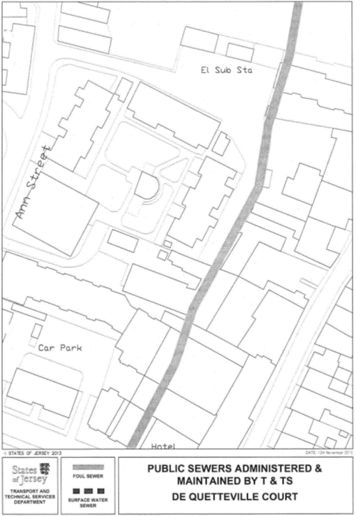
NOTE:
The public administers and
maintains as a public sewer the old town brook, Le Grand Douet, which is
now a foul sewer that enters the Property from the north from the Ann Street
Brewery site and flows along the eastern boundary of the Property.
The public does not maintain or
administer any drains within the Property or any road drainage system.
The routes of the public sewers
described above are as shown on the plan in this Part entitled “Public Sewers
administered and maintained by T&TS De Quetteville Court”.
The Property is situate in the
Parish of St. Helier in the Vingtaine de Haut de la Ville and has the
UPRN 69403784.
De Quetteville Court
Part
10
Clos
du Fort – Phases I and 2
(1) The
Property known as Clos du Fort (“the Property”), as shown on the Plan in this
Part entitled “Clos du Fort” – Phases I and 2, comprising 2 corpus fundi and to which the public has right by
the Contracts of Purchase dated –
(a) 1st March 1958 (PR 467C/267);
(b) 25th September 1954
(PR 460B/179);
(c) 14th November 1952
(PR 457A/38);
(d) 6th August 1955
(PR 462B/112);
(e) 6th August 1955
(PR 462B/113);
(f) 21st July 1967
(PR 532/327);
(g) 24th November 1967
(PR 537/482);
(h) 29th September 1972 (PR 602/205),
by way of exchange and counter exchange;
(i) 6th March 1987
(PR 827/272); and
(j) 19th May 1995
(PR 988/460),
(“Contracts of Purchase”),
and by way of Compulsory Purchase under the Compulsory Purchase of Land
(Procedure) (Jersey) Laws 1948 and 1953 by Acts of the Royal Court
dated –
(k) 18th February 1950 (PR 452C/31);
(l) 30th March 1951 (PR 453B/283);
(m) 16th February 1952 (PR 455C/240);
(n) 16th February 1952 (PR 455C/242);
(o) 3rd August 1957 (PR 466A/104),
(“Acts of the Royal
Court”).
(2) The
boundaries of the Property and all rights attaching thereto are set out –
(a) in the Contracts of
Purchase;
(b) in the Acts of the Royal
Court; and
(c) in sub-paragraphs (3),
(4), (5), (6), (7) and (8).
(3) The
boundary to the south or thereabouts of the first corpus
fundi of the Property is constituted by the granite wall towards the
steps leading to Fort Regent retained by the public which shall belong, without
offset, to the public.
(4) The
boundary line to the north or thereabouts of the first corpus fundi towards the tunnel retained by the
public is a line joining the coordinate boundary points numbered BP03 and BP04
on the boundary location plan in this Part bearing the reference M800/01 and
described in the Table in this Part.
(5) The
boundary line to the south or thereabouts of the second corpus fundi towards the tunnel retained by the
public is a line joining the coordinate boundary points numbered BP01 and BP02
on the boundary location plan in this Part bearing the reference M800/01 and
described in the Table in this Part.
(6) The
boundary line to the east or thereabouts of the first corpus fundi towards Fort Regent retained by the
public follows the base of the rock face forming part of Fort Regent until
reaching the boundary line to the north of the first corpus fundi.
(7) The
boundary line to the east or thereabouts of the second corpus fundi towards Fort Regent retained by the
public follows the base of the rock face forming part of Fort Regent from the
boundary line to the south until reaching the western or thereabouts boundary
of the second corpus fundi.
(8) The
company may keep, use, repair, replace and maintain all parts of building,
roadway, pavement, landscaped areas and any other thing constructed on the land
above the tunnel retained by the public situate between the first and second corpus fundi
as they are established and as they are used at the date of transfer.
NOTE:
The Property is situate in the
Parish of St. Helier in the Vingtaine de Haut de la Ville and has the
UPRN 69206344.
Clos du Fort – Phases I and 2
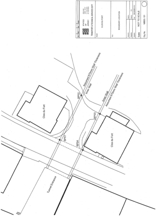
Table
|
Properties known as Clos
du Fort, Pier Road, St. Helier
|
|
Co-ordinate and
Descriptive Definition of the Boundary Points.
The following coordinate listing and description apply to boundary
location plan M800/01. The boundary points have coordinates currently used in
the Jersey Map Grid System 2004.
The following coordinates represent the boundary points.
|
|
Point No.
|
Easting
|
Northing
|
Description
|
|
BP01
|
42025.56E
|
651 68.05N
|
Boundary Point on line of back of path.
|
|
BP02
|
42043.29E
|
65159.48N
|
Boundary Point on
back of kerb line at rear of entrance to Clos du Fort Car Park and 19.69 metres
South Eastwards from BP01.
|
|
BP03
|
42035.92E
|
65151.85N
|
Boundary Point on
back of kerb line at rear entrance to Clos du Fort Car Park and
10.61 metres South Westwards from BP02.
|
|
BP04
|
42021.56E
|
65158.74N
|
Boundary Point on
line of back of footpath and 15.93 metres North Westwards from BP03 and 10.33
metres South West wards from BP01.
|
Part
11
Summerfield
Flats, Grouville
(1) The
property known as Summerfield Flats (“the Property”), as shown on the Plan in
this Part entitled “Summerfield Flats, Grouville”, to which the public has
right by contract of purchase dated 10th March 1978 (PR 684/121)
(“Contract of Purchase”).
(2) The
boundaries of the Property and all rights attaching thereto are as set out in
the Contract of Purchase.
NOTE:
The Property is situate in the
Parish of Grouville in the Vingtaine de la Rocque and has the
UPRN 69002707.
Summerfield Flats, Grouville
Part
12
St. George’s
Estate, St. Ouen
(1) The
property known as St. George’s Estate (“the Property”), as shown on the
Plan in this Part entitled “St. George’s Estate, St. Ouen”, to which
the public has right by contracts of purchase dated –
(a) 4th September 1948
(PR 449A/49); and
(b) 30th October 1948
(PR 449C/152),
(“Contracts of Purchase”).
(2) The
boundaries of the Property and all rights attaching thereto are as set out in
the Contracts of Purchase.
NOTE:
The Property is situate in the
Parish of St. Ouen in the Cueillette de Vinchelez and has the
UPRN 69408394.
St. George’s Estate, St. Ouen
Part
13
Woodlands
St. Brelade
(1) The
property known as Woodlands (“the Property”), as shown on the Plan in this Part
entitled “Woodlands St. Brelade”, to which the public has right (second corpus fundi) by contract of purchase dated 18th
November 1961 (PR 478A/194) (“Contract of Purchase”).
(2) The
boundaries of the Property and all rights attaching thereto are as set out in
the Contract of Purchase and the following contracts –
(a) the contract of sale of Le Petit
Charmoz (now called Bella Vista) dated 23rd September 1966 to which the
public was party (PR 520/321); and
(b) the contract of
arrangement between the public and others in respect of Nirvana (now called
Carden House) dated 6th October 1995 (PR 997/177).
NOTE:
The Property is situate in the
Parish of St. Brelade in the Vingtaine des Quennevais and has the
UPRN 69386674.
Woodlands St. Brelade
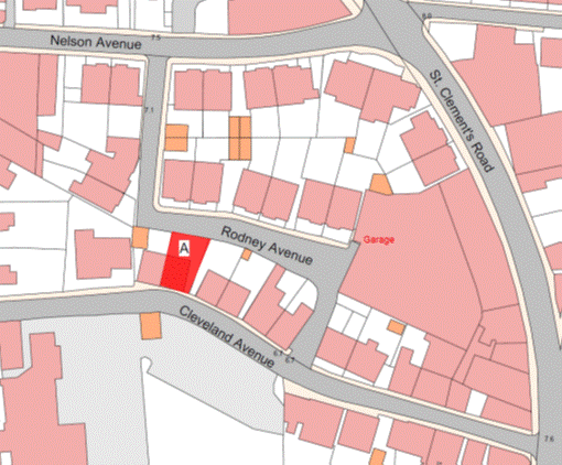
Part
14
2
Cleveland Avenue
(1) The
property known as 2 Cleveland Avenue (“the Property”), as shown on the Plan in
this Part entitled “2 Cleveland Avenue”, to which the public has right (amongst
other realty) by contract of purchase dated 24th March 1972
(PR 595/460) (“Contract of Purchase”).
(2) The
boundaries of the Property and all rights attaching thereto are as set out in
the Contract of Purchase and in the contract of sale of 1 Cleveland Avenue by
the public dated 14th July 1972 (PR 599/550).
NOTE:
The Property is situate in the
Parish of St. Helier in the Vingtaine de Haut de la Ville and has the
UPRN 69103400.
2 Cleveland Avenue
Part
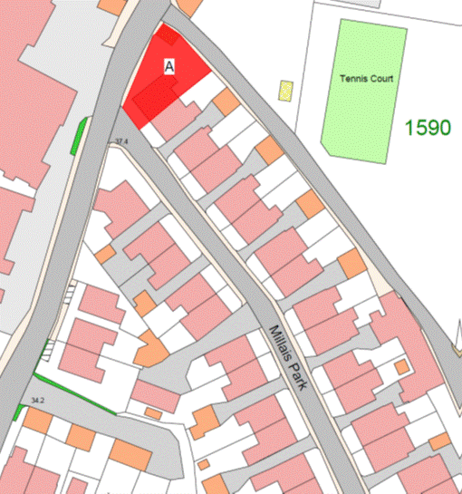
15
1
Millais Park
(1) The
property known as 1 Millais Park (“the Property”), as shown on the Plan in this
Part entitled “1 Millais Park”, to which the public has right by contract of
purchase dated 24th June 1950 (PR 452B/194) (“Contract of Purchase”).
(2) The boundaries of the Property and all
rights attaching thereto are as set out in the Contract of Purchase.
NOTE:
The Property is situate in the
Parish of St. Helier in the Vingtaine de Haut de la Ville and has the
UPRN 69129860.
1 Millais Park
Part 16
Belvoir
Court
(1) The
Property known as Belvoir Court (“the Property”), as shown on the Plan in this
Part entitled “Belvoir Court”, to which the public has right by the Acts of the
Royal Court registered under the Compulsory Purchase of
Land (Procedure) (Jersey) Law 1961 dated –
(a) 21st March 1969
(PR 555/183); and
(b) 21st March 1969
(PR 555/187),
(“Acts of the Royal
Court”).
(2) The
boundaries of the Property and all rights attaching thereto are as set out in
the Acts of the Royal Court.
NOTE:
The Property is situate in the
Parish of St. Helier in the Vingtaine de Haut de la Ville has the
UPRN 69386480.
Belvoir Court
Part 17
Mont
Surat
(1) The
property known as Mont Surat (“the Property”), as shown on the Plan in this
Part entitled “Mont Surat”, to which the public has right by contract of
purchase dated 7th November 1980 (PR 722/162) (“Contract of
Purchase”).
(2) The
boundaries of the Property and all rights attaching thereto are as set out in
the Contract of Purchase.
NOTE:
The Property is situate in the
Parish of St. Helier in the Vingtaine du Haut de la Ville and has the
UPRN 69002864.
Mont Surat
Part 18
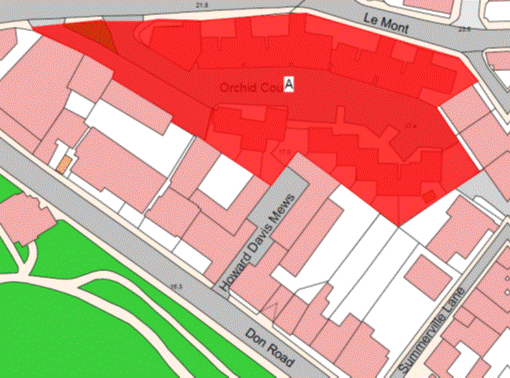
Orchid
Court
(1) The
Property known as Orchid Court (“the Property”), as shown on the Plan in this
Part entitled “Orchid Court”, to which the public has right by the contracts of
purchase dated –
(a) 14th August 1987
(PR 835/66); and
(b) 21st August 1987
(PR 835/193),
(“Contracts of Purchase”).
(2) The
boundaries of the Property and all rights attaching thereto are as set out in
the Contracts of Purchase and in the following contracts –
(a) sale by the public dated 20th
September 2002 (PR 1143/358);
(b) sale by the public dated
7th May 2010 (PR 1263/408); and
(c) Lease and Wayleave by the
public to Jersey Electricity Plc dated 29th July 2011 (PR 1283/44).
NOTE:
The Property is situate in the
Parish of St. Helier in the Vingtaine de Haut de la Ville and has the
UPRN 69206934.
Orchid Court
Part 19
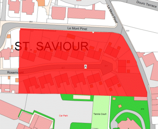
Rosemount
Estate, St. Saviour
(1) The
property known as Rosemount Estate (“the Property”), as shown on the Plan in
this Part entitled “Rosemount Estate, St. Saviour”, to which the public
has right by contract of purchase dated 4th August 1951 (PR 454B/182)
(“Contract of Purchase”).
(2) The
boundaries of the Property and all rights attaching thereto are as set out in
the Contract of Purchase.
NOTE:
The Property is situate in the
Parish of St. Saviour in the Vingtaine de la Petite Longueville and has
the UPRN 69386660.
Rosemount Estate, St. Saviour
Part 20
Le Bel
d’Enton (St. Aubin)
(1) The
Property known as Le Bel d’Enton (“the Property”), as shown on the Plan in
this Part entitled “Le Bel d’Enton (St. Aubin)”, to which the public
has right by the following contracts of purchase from –
(a) Des Pauvres de la
Paroisse de Saint Brélade dated 14th December 1979 (PR 710/384); and
(b) La Paroisse de Saint
Brélade dated 14th December 1979 (PR 710/386),
(“Contracts of Purchase”).
(2) The
boundaries of the Property and all rights attaching thereto are as set out –
(a) in the Contracts of
Purchase;
(b) the following contract –
Lease and Cession of
Wayleave Rights by the public to The Jersey Electricity Company Limited dated
4th February 2005 (PR 1179/648); and
(c) sub-paragraph (3).
(3) The
boundary separating the Property on its southern side towards the Railway Walk
retained by the public is constituted by the granite wall which shall be
transferred, without offset, to the company.
NOTE:
The Property is situate in the
Parish of St. Brelade in the Vingtaine de Noirmont and has the
UPRN 69002399.
Le Bel d’Enton (St. Aubin)
Part
21
19
La Cambrette, St. Clement
(1) The
property known as 19 La Cambrette (“the Property”), as shown on the
Plan in this Part entitled “19 La Cambrette, St. Clement”, to which
the public has right (inter alia) by contract
of purchase dated 6th December 1963 (PR 482C/36) (“Contract of
Purchase”).
(2) The
boundaries of the Property and all rights attaching thereto are as set out in
the Contract of Purchase and in the following –
(a) the declaration of
co-ownership of The Ernest Watson Close Residential Association which was
registered by Act of the Royal Court dated 7th October 1992
(PR 927/24); and
(b) the contract of sale of 18
La Cambrette by the public dated 9th December 2005
(PR 1193/702).
NOTE:
The Property is situate in the
Parish of St. Clement in the Vingtaine de Samarès and has the
UPRN 69127008.
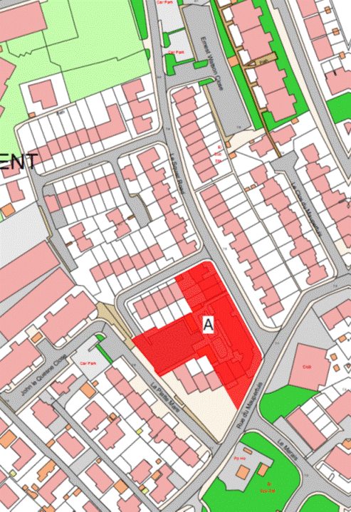
19 La Cambrette, St. Clement
Part
22
44, 45
and 46 Les Cloches and Les Cloches Court
(1) The
Property known as 44, 45 and 46 Les Cloches and Les Cloches Court
(“the Property”), as shown on the Plan in this Part entitled “44, 45 and 46 Les Cloches
and Les Cloches Court”, to which the public has right (inter alia) by contract of purchase dated 6th
December 1963 (PR 482C/36) (“Contract of Purchase”).
(2) The
boundaries of the Property and all rights attaching thereto are as set out in
the Contract of Purchase and in the following contracts of sale by the public –
(a) 43 Les Cloches dated 16th
May 2008 (PR 1236/291);
(b) 42 Les Cloches dated
30th November 2007 (PR 1228/412);
(c) 41 Les Cloches dated
7th December 2007 (PR 1228/490);
(d) 40 Les Cloches dated
28th March 2008 (PR 1233/939);
(e) 39 Les Cloches dated
14th December 2007 (PR 1229/404);
(f) 38 Les Cloches
dated 1st August 2008 (PR 1239/583);
(g) 47 Les Cloches 7th
December 2007 (PR 1228/726);
(h) 48 Les Cloches
dated 18th April 2008 (PR 1235/122); and
(i) 49 Les Cloches
dated 27th June 2008 (PR 1238/71).
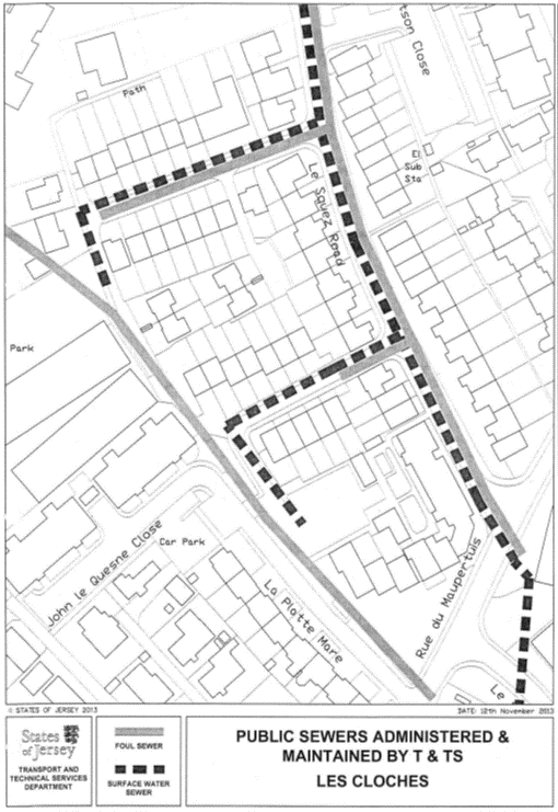
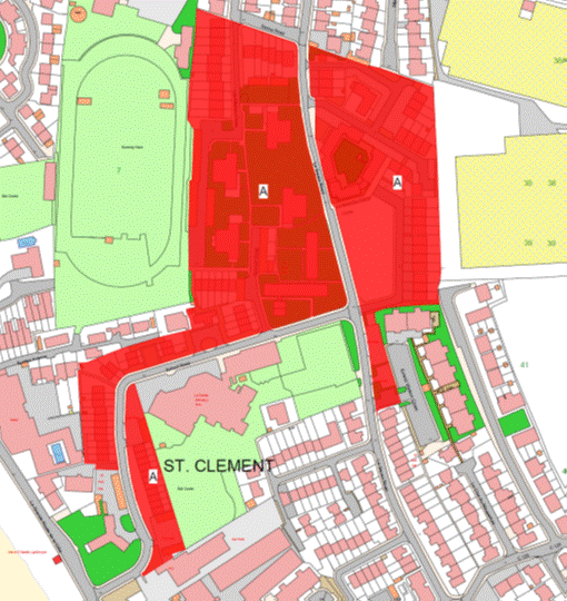
NOTE:
The public administers and maintains
the public foul and surface water sewers that lie under Le Squez Road to
the east of Les Cloches. Branch foul and surface water sewers extend from
these sewers between Nos. 3 and 25 Les Cloches in a westerly
direction where adjacent to No. 12 Les Cloches (formerly 1
Le Squez School House). The surface water sewer further extends to the
south to a point adjacent to No. 13 Les Cloches. Further branch foul
and surface water sewers extend to the west between Nos. 31 and 44
Les Cloches.
The routes of the public sewers
described above are as shown on the plan in this Part entitled “Public Sewers
administered and maintained by T&TS Les Cloches”.
The Property is situate in the
Parish of St. Clement in the Vingtaine de Samarès and have the
UPRN 69386684 and 69386647.
44, 45 and 46 Les Cloches and Les Cloches Court

Part
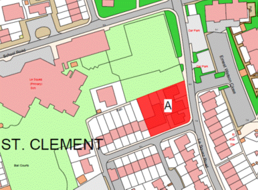
23
1, 2,
3, and Day Centre Les Cloches
(1) The
properties known as 1,2,3, and Day Centre Les Cloches (“the Properties”),
as shown on the Plan in this Part entitled “1, 2, 3, and Day Centre Les Cloches”,
and to which the public has right (inter alia)
by contract of purchase dated 6th December 1963 (PR 482C/36) (“Contract
of Purchase”).
(2) The
boundaries of the properties and all rights attaching thereto are as set out in
the Contract of Purchase and in the contract of sale of 4 Les Cloches by
the public dated 30th November 2007 (PR 1228/101) and sub-paragraph (3).
(3) The
wall and supporting pillars to the North of the Properties towards Le Squez
School shall continue to belong without offset to the public.
NOTE:
The public administers and
maintains the public foul and surface water sewers that lie under Le Squez
Road to the east of Les Cloches. Branch foul and surface water sewers
extend from these sewers between Nos. 3 and 25 Les Cloches in a
westerly direction where adjacent to No. 12 Les Cloches (formerly 1 Le Squez
School House). The surface water sewer further extends to the south to a point
adjacent to No. 13 Les Cloches. Further branch foul and surface water
sewers extend to the west between Nos. 31 and 44 Les Cloches.
The routes of the public sewers
described above are as shown on the plan in this Part entitled “Public Sewers
administered and maintained by T&TS Les Cloches”.
The properties are situate in the
Parish of St. Clement in the Vingtaine de Samarès and have the
UPRN 69386681 and 69406432.
1, 2, 3, and Day Centre Les Cloches
Part
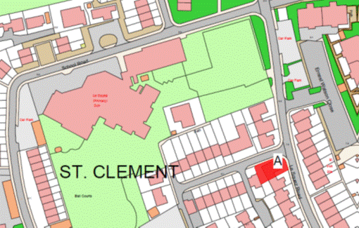
24
25 Les Cloches
(1) The
Property known as 25 Les Cloches (“the Property”), as shown on the Plan in
this Part entitled “25 Les Cloches”, and to which the public has right (inter alia) by contract of purchase dated 6th
December 1963 (PR 482C/36) (“Contract of Purchase”).
(2) The
boundaries of the Property and all rights attaching thereto are as set out in
the Contract of Purchase and in the contracts of sale by the public of –
(a) 24 Les Cloches dated
7th December 2007 (PR 1228/707); and
(b) 26 Les Cloches dated
25th April 2008 (PR 1235/608).
NOTE:
The public administers and
maintains the public foul and surface water sewers that lie under Le Squez
Road to the east of Les Cloches. Branch foul and surface water sewers
extend from these sewers between Nos. 3 and 25 Les Cloches in a
westerly direction where adjacent to No. 12 Les Cloches (formerly 1
Le Squez School House). The surface water sewer further extends to the
south to a point adjacent to No. 13 Les Cloches. Further branch foul
and surface water sewer extend to the west between Nos. 31 and 44
Les Cloches.
The routes of the public sewers
described above are as shown on the plan in this Part entitled “Public Sewers
administered and maintained by T&TS Les Cloches”.
The Property is situate in the
Parish of St. Clement in the Vingtaine de Samarès and has the
UPRN 69406457.
25 Les Cloches

Part
25
Le Squez
Estate and La Petite Mondine
(1) The
properties known as Le Squez Estate and La Petite Mondine (“the Properties”),
as shown on the Plan in this Part entitled “Le Squez Estate and La Petite
Mondine”, forming 4 corpus fundi to which the
public has right by the contracts of purchase dated –
(a) 13th December 1963
(PR 482B/262); and
(b) 27th June 2008
(PR 1238/147),
(“Contracts of Purchase”).
(2) The
boundaries of the Properties and all rights attaching thereto are as set out in –
(a) the Contracts of Purchase;
(b) 2 Acts of the Royal Court
dated 9th August 1963 (PR 482A/46 and 482A/48) whereby the public
acquired part of the Property by Compulsory Purchase under the Compulsory Purchase of
Land (Procedure) (Jersey) Law 1961;
(c) the following
contracts –
(i) Sale and Cession of Wayleave Rights by the
public to The Jersey Electricity Company Limited dated 8th April 1980
(PR 714/544),
(ii) Deed of Arrangement
dated 16th December 1983 (PR 772/625),
(iii) Deed of Arrangement dated
24th January 1986 (PR 807/133),
(iv) declaration of
co-ownership of The Ernest Watson Close Residential Association registered by
Act of the Royal Court dated 7th October 1992 (PR 927/24),
(v) sale by the public dated 9th June 2000
(PR 1100/41),
(vi) Deed of Arrangement dated
23rd April 2010 (PR 1262/722),
(vii) Lease and Cession of
Wayleave Rights by the public to Jersey Electricity Plc dated 29th
July 2011 (PR 1283/66), and
(viii) Deed of Arrangement between
the public and The Ernest Watson Close Residential Association (under the name
of The Ernest Watson Close Residents Association) dated 25th October 2013
(PR 1321/58); and
(d) sub-paragraphs (3),
(4), (5) and (6).
(3) The
wall of the east of Le Squez Primary School retained by Public towards a grass
verge forming part of the properties shall continue to belong, without offset,
to the public.
(4) The
wire fences and wall of the west of Le Squez Primary School retained by
the public towards the properties shall continue to belong, without offset, to
the public.
(5) The
wire fences to the east or thereabouts of FB fields retained by the public
towards the properties shall continue to belong, without offset, to the public.
(6) The
wooden fence to the north of La Petite Mondine forming part of the properties
shall be transferred, without offset, to the company.
(7) The
wooden fence to the north of Maison d’Azette retained by the Public towards a
road leading to the property called “Southern Rock” shall continue to belong,
without offset, to the Public.
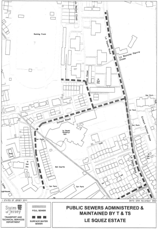
NOTE:
The
public administers and maintains both public foul and surface water sewers in
the both Le Squez Road and School Road. The current public foul water
sewer extends off Le Squez Road to the west between Blocks C and D and
then heads north to the junction with Sarina Road. A public surface water sewer
extends north from Le Squez Youth Club to the west of Block G and
then turns west to the south of Block F to the boundary of F.B. Fields
where it drains that property.
The current routes of the public sewers
described above are as shown on the plan in this Part entitled “Public Sewers
administered and maintained by T&TS Le Squez Estate”.
The Property is situate in the
Parish of St. Clement in the Vingtaine de Samarès and has the
UPRN 69407201 and 69133795.
Le Squez Estate and La Petite Mondine
Part
26
Clos
de l’Arsenal, St. Mary (Nos. 24, 25, 26 and 27)
(1) The
properties known as numbers 24, 25, 26 and 27 Clos de l’Arsenal, landscaped
area and roadways (“the Properties”), as shown on the Plan in this Part
entitled “Clos de l’Arsenal, St. Mary (Nos. 24, 25, 26 and 27)”, to
which the public has right (inter alia) by
contract of purchase dated 30th December 1843 from Jean Binet (PR 183/16)
(“Contract of Purchase”).
(2) The
boundaries of the Properties and all rights attaching thereto are as set out in
the Contract of Purchase and in the contracts of sale by the public
dated –
(a) 16th April 1974
(PR 624/252);
(b) 16th April 1974
(PR 624/257);
(c) 16th April 1974
(PR 624/273);
(d) 16th April 1974 (PR 624/324);
(e) 16th April 1974
(PR 624/336);
(f) 16th April 1974
(PR 624/342);
(g) 16th April 1974
(PR 624/352);
(h) 3rd May 1974
(PR 625/29);
(i) 3rd May 1974
(PR 625/34);
(j) 3rd May 1974
(PR 625/50);
(k) 3rd May 1974
(PR 625/55);
(l) 3rd May 1974
(PR 625/79);
(m) 3rd May 1974
(PR 625/96);
(n) 3rd May 1974
(PR 625/161);
(o) 3rd May 1974
(PR 625/168);
(p) 10th May 1974
(PR 625/220);
(q) 10th May 1974
(PR 625/236);
(r) 10th May 1974
(PR 625/250);
(s) 10th May 1974
(PR 625/271);
NOTE:
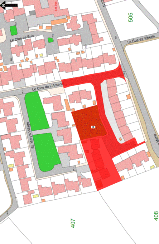
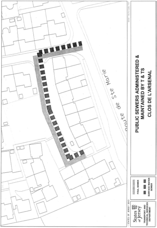
The public administers and
maintains both public foul and surface water sewers that enter the Properties
from La Route de Ste Marie and immediately turn to the west as far as the
open parking area where they turn to the south to a point adjacent to
No. 30 Clos de l’Arsenal.
The public does not maintain or
administer any branch connections from these public sewers to the Properties or
any road drainage system in the roads and parking areas within the Properties.
The routes of the public sewers
described above are as shown on the plan in this Part entitled “Public Sewers
administered and maintained by T&TS Clos de l’Arsenal”.
The Properties are situate in the
Parish of St. Mary in the Vingtaine du Sud and have the
UPRNs 69123148, 69123149, 69123150 and 69123151.
Clos de l’Arsenal, St. Mary (Nos. 24, 25, 26 and 27)
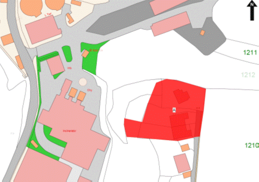
Part
27
Pine
Ridge, Narkunda and Chantemerle
(1) The
properties known as Pine Ridge, Narkunda and Chantemerle, forming one corpus fundi, (“the Properties”), as shown on the
Plan in this Part entitled “Pine Ridge, Narkunda and Chantemerle”, to which the
public has right by the contracts of purchase dated –
(a) 12th May 2000
(PR 1098/344);
(b) 5th May 2000
(PR 1098/120); and
(c) 11th February 2000
(PR 1093/325),
(“Contracts of Purchase”).
(2) The boundaries of the Properties and all
rights attaching thereto are as set out in the Contracts of Purchase and in
sub-paragraph (3).
(3) The
boundary line separating the Properties from the property retained by the
public is a line joining the coordinate boundary points numbered BP01 to BP13
on the boundary location plan in this Part bearing the reference M713/01 and
described in the Table in this Part.
NOTE:
The Properties are situate in the
Parish of St. Helier, Vingtaine du Mont-à-l’Abbé and has the
UPRNs 69137468, 69137466 and 69137440.
Pine Ridge, Narkunda and Chantemerle
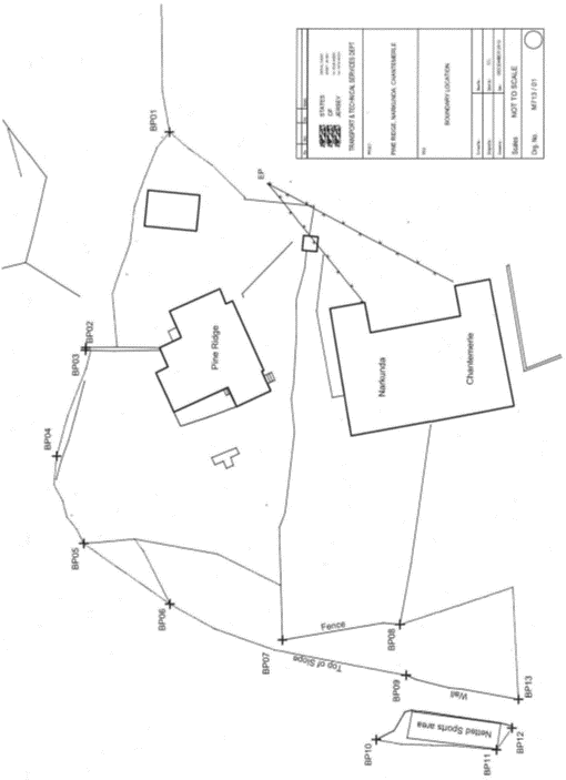
Table
|
Properties known as Pine
Ridge, Narkunda and Chantemerle, West Hill, St. Helier
|
|
Co-ordinate and
Descriptive Definition of the Boundary Points.
The following coordinate listing and description apply to boundary
location plan M713/01. The boundary points have coordinates currently used in
the Jersey Map Grid System 2004.
The following coordinates represent the boundary points.
|
|
Point No.
|
Easting
|
Northing
|
Description
|
|
BP01
|
41040.73E
|
67161.00N
|
Boundary Point on top of embankment at the North East corner of Pine
Ridge garden.
|
|
BP02
|
41016.14E
|
67170.48N
|
Boundary Point on North Eastern corner of wall which runs Northwards
from house and 26.35 metres North Westwards from BP01.
|
|
BP03
|
41015.84E
|
67170.53N
|
Boundary Point on North Western corner of wall which runs Northwards
from house and 0.30 metres Westwards from BP02.
|
|
BP04
|
41003.69E
|
67173.82N
|
Boundary Point at Western end of and on top of slope forming the
Northern boundary of property and 12.58 metres Westwards from BP03.
|
|
BP05
|
4099.71E
|
67170.66N
|
Boundary Point at Northern end of and on top of slope forming the
Western boundary of the property and 10.47 metres South Westwards from BP04.
|
|
BP06
|
40986.81E
|
67160.75N
|
Boundary Point on top of slope forming Western edge of property
boundary and 12.08 metres Southwards from BP05.
|
|
BP07
|
40982.72E
|
67147.74N
|
Boundary Point on corner of fence forming the North West Boundary of
property known as Narkunda and 13.64 metres Southwards from BP06.
|
|
BP08
|
40984.50E
|
67134.12N
|
Boundary Point on corner of fence forming the South West Boundary of
Property known as Narkunda and 13.74 metres Southwards from BP07.
|
|
BP09
|
40978.72E
|
67133.39N
|
Boundary Point on North end of low wall and 5.82 metres Westwards
from BP08.
|
|
BP10
|
40971.36E
|
67136.79N
|
Boundary Point on top of slope and 8.10 metres Westwards from
BP09.
|
|
BP11
|
40970.21E
|
67123.03N
|
Boundary Point on top of slope and 13.81 metres Southwards from
BP10.
|
|
BP12
|
40972.69E
|
67121.20N
|
Boundary point at the bottom of small slope and 3.07 metres South
Eastwards from BP11 and 13.61 metres South-SouthWestwards from BP09.
|
|
BP13
|
40975.98E
|
67120.48N
|
Boundary Point on Southern end of low wall and 3.37 metres Eastwards
from BP12 and 13.20 metres Southwards from BP09.
|
Part
28
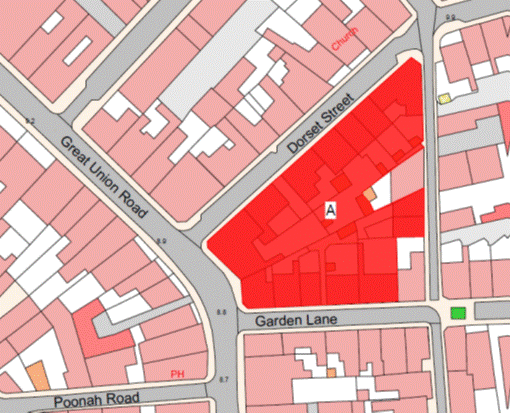
Dorset
Street and Windsor Road properties
2, 2a, 4, 6, 8, 8a and 10 Dorset Street,
60 Great Union Road, 55a and 55b Garden Lane, 1, 3a, 3b, 5a and 5b Windsor Road
(1) The
properties now known as Numbers 2, 2a, 4, 6, 8, 8a and 10 Dorset Street, Number
60 Great Union Road, Numbers 55a and 55b Garden Lane and Numbers 3a, 3b, 5a and
5b Windsor Road, forming one corpus fundi
(“the Properties”), as shown on the Plan in this Part entitled “Dorset Street
and Windsor Road Properties”, to which the public has right by the contracts of
purchase dated –
(a) in respect of the Dorset
Street properties –
(i) 1st December 1972 (PR 605/179),
(ii) 25th November 1966
(PR 523/80),
(iii) 10th December 1971
(PR 591/225),
(iv) 3rd April 1970
(PR 566/468), and
(v) 19th March 1971 (PR 580/117);
(b) in respect of 60 Great
Union Road, 18th January 1980 (PR 711/548);
(c) in respect of the Windsor
Road properties –
(i) 30th November 1979 (PR 709/565),
(ii) 11th February 1983
(PR 757/276),
(iii) 3rd December 1982
(PR 753/535),
(iv) 31st May 1968
(PR 545/559),
(v) 13th September 1968 (PR 549/161),
(vi) 1st August 1975
(PR 641/399), and
(vii) 14th August 1970
(PR 571/173); and
(d) in respect of 55a and 55b
Garden Lane, 20th July 1973 (PR 615/58),
(“Contracts of Purchase”).
(2) The
boundaries of the Properties and all rights attaching thereto are as set out in
the Contracts of Purchase and in –
(a) the contract of Sale of
Rights by the public dated 1st February 1991 (PR 895/106); and
(b) the contract of Sale of
No. 59 Garden Lane dated 7th May 1993 (PR 940/306).
NOTE:
The Properties are situate in the
Parish of St. Helier in the Vingtaine de Rouge Bouillon and has the
UPRNs 69386680, 69386635 and 69386673.
Dorset Street and Windsor Road properties
Part
29
Haut
du Mont
(1) The
Property called Haut du Mont (“the Property”), as shown on the Plan in this
Part entitled “Haut du Mont”, to which the public has right by contract of
purchase (11th corpus fundi) dated 1st March 1958
from Her Majesty (PR 467C/267) (“Contract of Purchase”).
(2) The
boundaries of the Property and all rights attached thereto are as set out in
the Contract of Purchase.
NOTE:
The
Property is situate in the Parish of Saint Helier in the Vingtaine of Haut de
la Ville and has the UPRN 69386642.
Haut du Mont
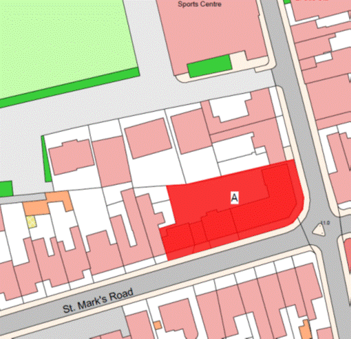
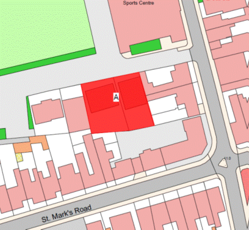
Part
30
Strathmore,
80 St. Mark’s Road
(1) The
property known as Strathmore, 80 St. Mark’s Road (“the Property”), as
shown on the Plan in this Part entitled “Strathmore, 80 St. Mark’s Road”,
to which the public has right by contract of purchase dated 8th September 1989
(PR 870/663) (“Contract of Purchase”).
(2) The
boundaries of the Property and all rights attaching thereto are as set out in
the Contract of Purchase and in the Deed of Arrangement between the public and Les Vaux
Housing Trust dated 9th September 1994 (PR 973/209).
NOTE:
The Property is situate in the
Parish of St. Saviour in the Vingtaine de Sous l’Eglise and has the
UPRN 69002733.
Strathmore, 80 St. Mark’s Road
Part 31
Le Jardin
des Carreaux
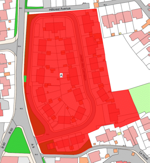
(1) The
Property known as Le Jardin des Carreaux (“the Property”), as shown on the
Plan in this Part entitled “Le Jardin des Carreaux”, to which the public
has right by the contracts of purchase dated –
(a) 10th July 1948
(PR 448A/252); and
(b) 22nd December 2000
(PR 1110/190),
(“Contracts of Purchase”).
(2) The
boundaries of the Property and all rights attaching thereto are as set out in
the Contracts of Purchase and in the following contracts –
(a) Gift, Cession and
Transfer of rights to the public dated 14th December 1979
(PR 710/388);
(b) sale by the public dated
12th June 1981 (PR 729/691);
(c) sale by the public
dated 19th June 1981 (PR 730/192);
(d) Lease and Cession of
Wayleave Rights by the public to The Jersey Electricity Company Limited dated
1st February 2002 (PR 1131/228); and
(e) lease by the public dated
15th January 2010 (PR 1259/850).
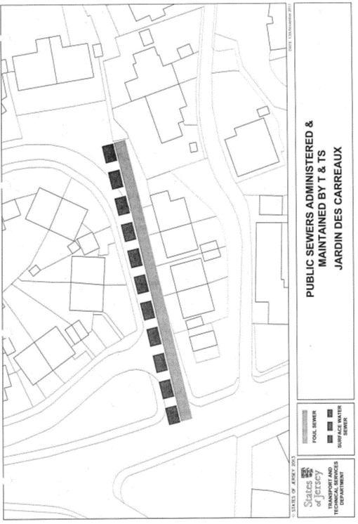
NOTE:
The Department administers and
maintains the public main foul and surface water sewers under the road forming
part of the Property from the junction with Queen’s Road and heading east to
the approximate area of the pedestrian access leading to the old
La Pouquelaye School.
The Department does not maintain
or administer any branch connection from these sewers to the buildings or any
road drainage system in the roads forming parts of the Property.
The routes of the public sewers
described above are as shown on the plan in this Part entitled “Public Sewers
administered and maintained by T&TS Jardin des Carreaux”.
The Property is situate in the
Parish of St. Helier in the Vingtaine de Mont à l’Abbé and has the
UPRN 69207643.
Le Jardin des Carreaux
Part
32
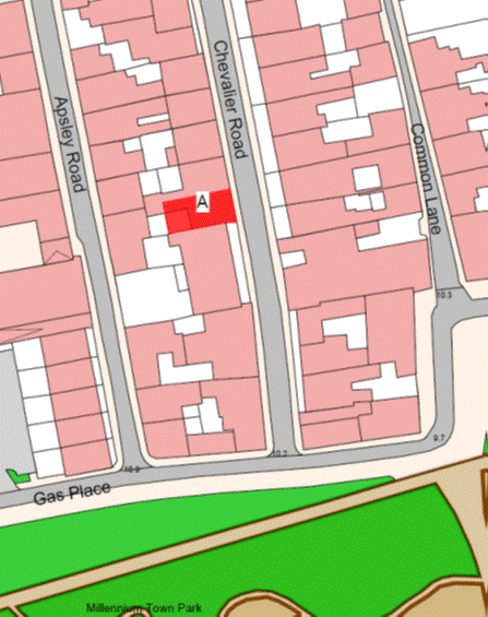
14
Chevalier Road
(1) The
property known as 14 Chevalier Road (“the Property”), as shown on the Plan in
this Part entitled “14 Chevalier Road”, to which the public has right by
contract of purchase dated 3rd March 1978 (PR 683/544) (“Contract of
Purchase”).
(2) The
boundaries of the Property and all rights attaching thereto are as set out in
the Contract of Purchase.
NOTE:
The Property is situate in the
Parish of St. Helier in the Vingtaine du Bas du Mont au Prêtre and has the
UPRN 69102920.
14 Chevalier Road
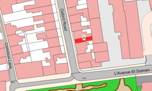
Part
33
25
Oxford Road
(1) The
property known as 25 Oxford Road (“the Property”), as shown on the Plan in this
Part entitled “25 Oxford Road”, to which the public has right by contract of
purchase dated 17th November 1978 (PR 696/459) (“Contract of
Purchase”).
(2) The
boundaries of the Property and all rights attaching thereto are as set out in
the Contract of Purchase.
NOTE:
The Property is situate in the
Parish of St. Helier in the Vingtaine du Bas du Mont au Prêtre and has the
UPRN 69130740.
25 Oxford Road
Part
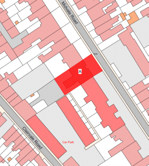
34
19
Midvale Road
(1) The
property known as 19 Midvale Road (“the Property”), as shown on the Plan
in this Part entitled “19 Midvale Road”, to which the public has right by
contract of purchase dated 15th September 2000 (PR 1105/123)
(“Contract of Purchase”).
(2) The
boundaries of the Property and all rights attaching thereto are as set out in the
Contract of Purchase.
NOTE:
The
Property is situate in the Parish of St. Helier in the Vingtaine du Bas du
Mont au Prêtre and has the UPRN 69407059.
19 Midvale Road
Part
35
Langtry
Gardens
(1) The
property known as Langtry Gardens (“the Property”), as shown on the Plan in
this Part entitled “Langtry Gardens”, and to which the public has right by
contract of purchase dated 8th March 2013 (PR 1308/917) (“Contract of
Purchase”).
(2) The
boundaries of the Property and all rights attaching thereto are as set out in
the Contract of Purchase and in the contract of Gift Cession and Transfer to
the Public dated 24th May 2013 (PR 1312/640).
NOTE:
The
Property is situate in the Parish of St. Saviour in the Vingtaine de Sous
l’Eglise and having the UPRN 69387152 and 69387153.
Langtry Gardens
Part
36
Highbury
Court
(1) The
property known as Highbury Court (“the Property”), as shown on the Plan in this
Part entitled “Highbury Court”, and to which the public has right by the
contracts of purchase dated –
(a) 12th March 1982
(PR 740/430); and
(b) 12th June 1987
(PR 832/1),
(“Contracts of Purchase”).
(2) The
boundaries of the Property and all rights attaching thereto are as set out in
the Contracts of Purchase.
NOTE:
The Property is situate in the
Parish of St. Saviour in the Vingtaine de Sous l’Eglise and has the
UPRN 69002544.
Highbury Court
Part
37
Peirson
Court
(1) The
Property known as Peirson Court (“the Property”), as shown on the Plan in this
Part entitled “Peirson Court”, and to which the public has right by the
contracts of purchase dated –
(a) 30th March 1990
(PR 880/598); and
(b) 17th October 1980
(PR 721/308),
(“Contracts of Purchase”).
(2) The
boundaries of the Property and all rights attaching thereto are as set out in
the Contracts of Purchase and in sub-paragraph (3).
(3) The
walls to the North of the Property towards Springfield Lane retained by the
public shall be transferred, without offset, to the company.
NOTE:
The Property is situate in the
Parish of St. Helier in the Vingtaine du Bas du Mont au Prêtre and has the
UPRN 69408401.
Peirson Court
Part
38
Sydenham
Villas
(1) The
property known as Sydenham Villas (“the Property”), as shown on the Plan in
this Part entitled “Sydenham Villas”, to which the public has right by contract
of purchase dated 24th December 1982 (PR 755/184) (“Contract of
Purchase”).
(2) The
boundaries of the Property and all rights attaching thereto are as set out in
the Contract of Purchase.
NOTE:
The
Property is situate in the Parish of St. Helier in the Vingtaine de Bas du
Mont au Prêtre and has the UPRN 69002087.
Sydenham Villas

Part
39
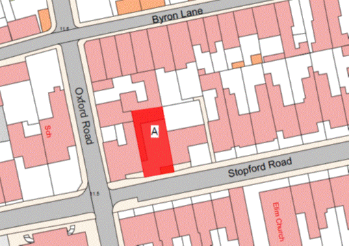
39
Stopford Road
(1) The
property known as 39 Stopford Road (“the Property”), as shown on the Plan in
this Part entitled “39 Stopford Road”, to which the public has right by
contract of purchase dated 12th August 1983 (PR 766/271) (“Contract
of Purchase”).
(2) The
boundaries of the Property and all rights attaching thereto are as set out in
the Contract of Purchase.
NOTE:
The Property is situate in the
Parish of St. Helier in the Vingtaine du Bas du Mont au Prêtre and has the
UPRN 69135365.
39 Stopford Road
Part
40
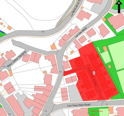
Town
Mills
(1) The
property known as Town Mills (“the Property”), as shown on the Plan in this
Part entitled “Town Mills”, to which the public has right by the contracts of
purchase dated –
(a) 9th July 1898
(PR 326/16); and
(b) 10th December 1910
(PR 356/75),
(“Contracts of Purchase”).
(2) The
boundaries of the Property and all rights attaching thereto are as set out in –
(a) the Contracts of Purchase;
(b) the contract of transaction
dated 30th July 1993 (PR 946/328); and
(c) sub-paragraphs (3)
and (4).
(3) The
boundary to the East and partly to the South of the Property towards the
surface water culvert retained by the public shall be constituted by the
granite wall which shall be transferred to the company, without offset.
(4) The
walls to the south on 2 sections of the property known as Old Mill House
retained by the public towards the Property shall belong, without offset, to
the public and the walls to the east on 2 sections of Old Mill House towards
the Property shall be party owned between the parties.
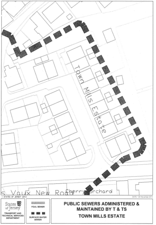
NOTE:
The
public administers and maintains a large surface water culvert that drains the
Vallée des Vaux catchment and enters the Property at the north-west corner,
under the play area, and flows in an easterly direction to the north-east
corner of the Property. The culvert then drains to the south in an open channel
to the east of the Property before turning in a westerly direction into a
covered culvert between Nos. 17 and 18 Town Mills and Les Vaux
New Road.
The public does not maintain or
administer any foul or surface water sewer or any road drainage system within
the Property.
The route of the public sewer
described above is as shown on the plan in this Part entitled “Public Sewers
administered and maintained by T&TS Town Mills Estate”.
The Property is situate in the
Parishes of St. Helier and St. Saviour in the Vingtaines of Haut du
Mont au Prêtre and Sous l’Eglise and has the UPRN 69380192.
Town Mills
Part
41
78
St. Saviour’s Road
(1) The
property known as 78 St. Saviour’s Road (“the Property”), as shown on the
Plan in this Part entitled “78 St. Saviour’s Road”, to which the public
has right by contract of purchase dated 27th February 1981 (PR 726/1)
(“Contract of Purchase”).
(2) The
boundaries of the Property and all rights attaching thereto are as set out in
the Contract of Purchase.
NOTE:
The Property is situate in the
Parish of St. Helier in the Vingtaine du Haut de la Ville and has the
UPRN 69002556.
78 St. Saviour’s Road
Part
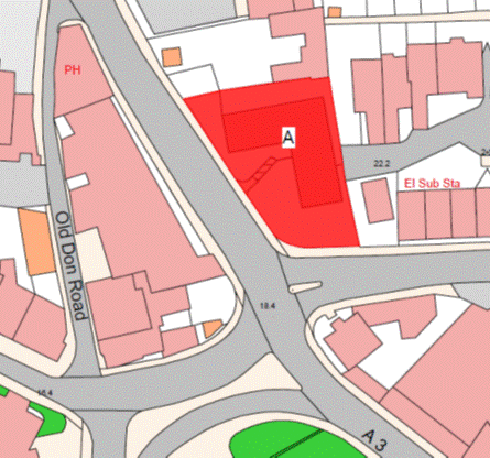
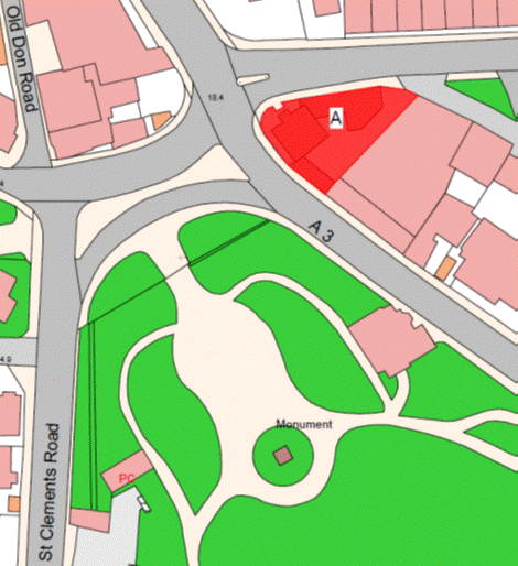
42
Rocheby,
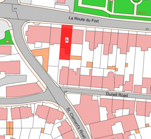
La Route du Fort
(1) The
Property known as Rocheby (“the Property”), as shown on the Plan in this Part
entitled “Rocheby, La Route du Fort”, to which the public has right by
contract of purchase dated 14th August 1992 (PR 923/298) (“Contract
of Purchase”).
(2) The
boundaries of the Property and all rights attaching thereto are as set out in
the Contract of Purchase and in a Deed of Arrangement dated 13th
October 2006 (PR 1209/10).
NOTE:
The
Property is situate in the Parish of St. Saviour in the Vingtaine de la
Petite Longueville and has the UPRN 69114697.
Rocheby, La Route du Fort
Part
43
37
Midvale Road
(1) The
Property known as 37 Midvale Road (“the Property”), as shown on the Plan in
this Part entitled “37 Midvale Road”, to which the public has right by contract
of purchase dated 16th December 1966 (PR 524/56) (“Contract of
Purchase”).
(2) The
boundaries of the Property and all rights attaching thereto are as set out in
the Contract of Purchase and in the contract of sale of 39 Midvale Road by the
public dated 21st December 2007 (PR 1230/352).
NOTE:
The Property is situate in the
Parish of St. Helier in the Vingtaine du Rouge Bouillon and has the
UPRN 69003151.
37 Midvale Road
Part
44
Durban
House Flats
(1) The
Property known as Durban House Flats (“the Property”), as shown on the Plan in
this Part entitled “Durban House Flats”, to which the public has right by
contract of purchase dated 9th December 1977 (PR 679/380) (“Contract
of Purchase”).
(2) The
boundaries of the Property and all rights attaching thereto are as set out in
the Contract of Purchase and a Deed of Arrangement dated 21st August 1992
(PR 923/495).
NOTE:
The Property is situate in the
Parish of St. Helier in the Vingtaine du Rouge Bouillon and has the
UPRN 69386636.
Durban House Flats
Part
45
15
Beach Crescent
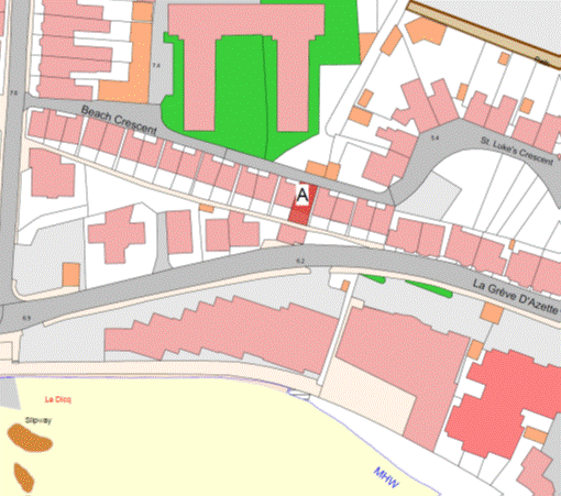
(1) The
Property known as 15 Beach Crescent (“the Property”), as shown on the Plan in
this Part entitled “15 Beach Crescent”, to which the public has right by
contract of purchase dated 16th August 1985 (PR 799/20)
(“Contract of Purchase”).
(2) The
boundaries of the Property and all rights attaching thereto are as set out in
the Contract of Purchase.
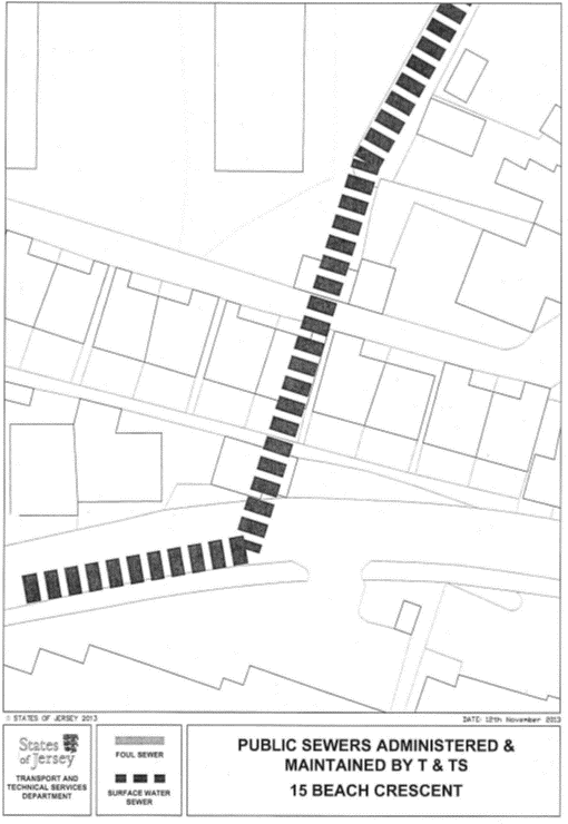
NOTE:
The
public administers and maintains a large public surface water sewer that
crosses under the Property in a north to south direction from the Baudrette
Brook to the north, adjacent to Spencer Close, to La Greve d’Azette. The
culvert under the garages to the south of the Property was constructed under
Royal Court notices dated 14th January 1986 and 20th
August 1998.
The public does not maintain or
administer any other sewer infrastructure associated with the Property.
The route of the public sewer
described above is as shown on the plan in this Part entitled “Public Sewers
administered and maintained by T&TS 15 Beach Crescent”.
The Property is situate in the
Parish of St. Clement in the Vingtaine de Samarès and has the
UPRN 69101227.
15 Beach Crescent
Part
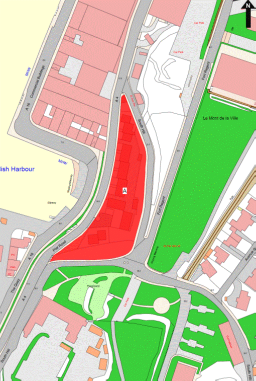
46
1
Commercial Buildings
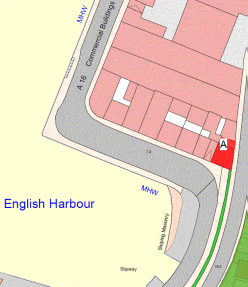
(1) The
Property known as 1 Commercial Buildings (“the Property”), as shown on the Plan
in this Part entitled “1 Commercial Buildings”, to which the public has right
by contract of purchase dated 14th June 1991 (PR 901/299) (“Contract
of Purchase”).
(2) The
boundaries of the Property and all rights attaching thereto are as set out in
the Contract of Purchase and in sub-paragraph (3).
(3) The
granite wall to the East of the Property that forms part of Pier Road retained
by the public shall continue to belong to the public, without offset.
NOTE:
The Property is situate in the
Parish of St. Helier in the Vingtaine du Haut de la Ville and has the
UPRN 69103900.
1 Commercial Buildings
Part
47
21
Duhamel Place
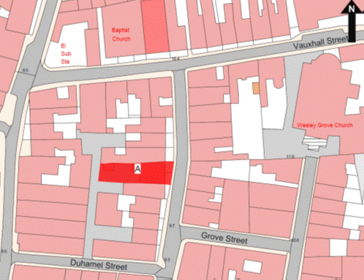
(1) The
Property known as 21 Duhamel Place (“the Property”), as shown on the Plan in
this Part entitled “21 Duhamel Place”, to which the public has right by
contract of purchase dated 14th August 1981 (PR 732/82) (“Contract of
Purchase”).
(2) The
boundaries of the Property and all rights attaching thereto are as set out in
the Contract of Purchase.
NOTE:
The Property is situate in the
Parish of St. Helier in the Vingtaine du Bas du Mont au Prêtre and has the
UPRN 69003046.
21 Duhamel Place
Part
48
63 New
Street
(1) The
Property known as 63 New Street (“the Property”), as shown on the Plan in this
Part entitled “63 New Street”, to which the public has right by contract of
purchase dated 12th August 1961 (PR 478B/13) (“Contract of
Purchase”).
(2) The
boundaries of the Property and all rights attaching thereto are as set out in
the Contract of Purchase.
NOTE:
The
Property is situate in the Parish of St. Helier in the Vingtaine du Bas du
Mont au Prêtre and has the UPRN 69130208.
63 New Street
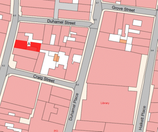
Part
49
Halcyon
House
(1) The
Property known as Halcyon House (“the Property”), as shown on the Plan in this
Part entitled “Halcyon House”, to which the public has right by contract of
purchase dated 18th October 1985 (PR 802/112) (“Contract of
Purchase”).
(2) The
boundaries of the Property and all rights attaching thereto are as set out in
the Contract of Purchase and in the contract of Sale and Cession of Wayleave Rights
by the public to The Jersey Electricity Company Limited dated 20th
March 1987 (PR 828/219).
NOTE:
The Property is situate in the
Parish of St. Helier in the Vingtaine du Mont à l’Abbé and has the
UPRN69002624.
Halcyon House
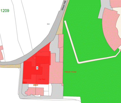
Part
50
St. Martin’s
Arsenal and 1 and 2 Yew Cottages
(1) The
Property known as St. Martin’s Arsenal and 1 and 2 Yew Cottages (“the
Property”), as shown on the Plan in this Part entitled “St. Martin’s
Arsenal and 1 and 2 Yew Cottages”, to which the public has right by contract of
purchase dated 3rd September 1842 (PR 178/255) (“Contract of
Purchase”).
(2) The
boundaries of the Property and all rights attaching thereto are as set out in
the Contract of Purchase and in the contract of Lease and Cession of Wayleave Rights
by the public to The Jersey Electricity Company Limited dated 18th
April 1997 (PR 1030/184).
NOTE:
The Property is situate in the
Parish of St. Martin in the Vingtaine de Rozel and has the
UPRN 69201284 and 69386677.
St. Martin’s Arsenal and 1 and 2 Yew Cottages
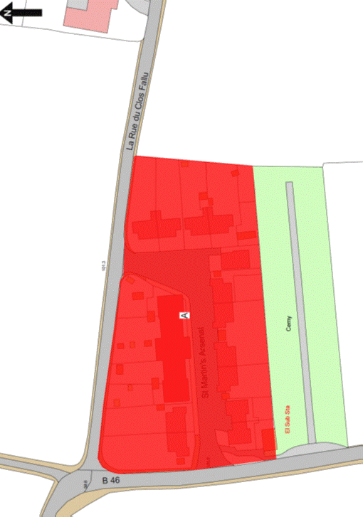
Part
51
Le Clos
de Roncier
(1) The
Property known as Le Clos de Roncier (“the Property”), as shown on the
Plan in this Part entitled “Le Clos de Roncier”, to which the public has
right by compulsory purchase under the Compulsory Purchase of Land (Procedure)
(Jersey) Law 1948 by Act of the Royal Court dated 30th March 1951
(PR 453B/282) (“Act of the Royal Court”) and by the contracts of purchase dated –
(a) 16th May 1953
(PR 458C/47);
(b) 12th July 1968
(PR 547/283);
(c) 12th July 1968
(PR 547/285); and
(d) 29th November 2013
(PR 1322/618),
(“Contracts of Purchase”).
(2) The
boundaries of the Property and all rights attaching thereto are as set out in
the Act of the Royal Court, the Contracts of Purchase and in the contracts of
sale by the public to –
(a) The Jersey New Waterworks
Company Limited dated 3rd December 1993 (PR 955/474);
(b) The Jersey Electricity
Company Limited dated 22nd November 1996 (PR 1022/360); and
(c) The Jersey Electricity Company
Limited dated 15th February 2008 (PR 1232/219).
NOTE:
The public foul and surface water
sewers administered and maintained by the public enter the Property from
Field 167 in the south-east corner of No. 25 Clos de Roncier then
split into 2 directions, west and north. The westerly branches of the public
foul and surface water sewers continue through the garden of No. 25 Clos
de Roncier across the road and then through the garden of No. 26 Clos de
Roncier before crossing the children’s play area to the south of No. 38
Clos de Roncier and entering into the road adjacent to No. 41 Clos de
Roncier. The northerly branch of the public foul and surface water sewers
extend under the road to the west of Nos. 17 and 18 Clos de Roncier
and extend to the north-west corner of the Property adjacent and to the east of
No. 63 Clos de Roncier. A westerly branch of public foul and surface water
sewers extend to the west from the road junction adjacent to Nos. 68 and
69 Clos de Roncier and follows the line of the road as far as to the south of
No. 54 Clos de Roncier. A branch public surface water sewer extends to the
south from this point down through a parking area between Nos. 78 and 79
Clos de Roncier.
The public does not maintain or
administer any branch connection from these public sewers to the properties or
any road drainage system in the roads forming parts of the Property.
The routes of the public sewers
described above are as shown on the plan in this Part entitled “Public Sewers
administered and maintained by T&TS Clos de Roncier”.
The Property is situate in the
Parish of St. Clement in La Grande Vingtaine and has the
UPRN 69381822.
Le Clos de Roncier
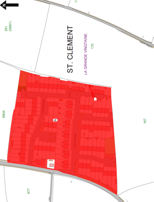
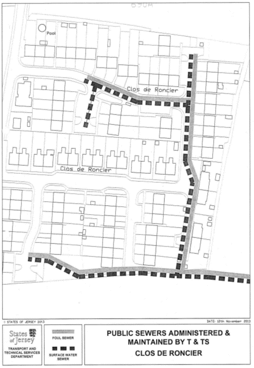
Part
52
Maison
Le Fondré
(1) The
property known as Maison Le Fondré Nos. 9 – 11 Don Road (“the
Property”), as shown on the Plan in this Part entitled “Maison Le Fondré”,
to which the public has right by contract of purchase dated 17th January 1992
(PR 912/259) (“Contract of Purchase”).
(2) The
boundaries of the Property and all rights attaching thereto are as set out in
the Contract of Purchase.
NOTE:
The Property is situate in the
Parish of St. Helier in the Vingtaine du Haut de la Ville and has the
UPRN 69002105.
Maison Le Fondré
Part
53
La Carrière,
Bellozanne Valley
(1) The
Property known as La Carrière (“the Property”), as shown on the Plan in
this Part entitled “La Carrière, Bellozanne Valley”, to which the public
has right by contract of purchase dated 11th June 1999 (PR 1078/329)
(“Contract of Purchase”).
(2) The
boundaries of the Property and all rights attaching thereto are as set out in
the Contract of Purchase and in the Deed of Arrangement dated 25th February 2000
(PR 1094/155).
NOTE:
The Property is situate in the
Parish of St. Helier in the Vingtaine du Mont Cochon and has the
UPRN 69101710.
La Carrière, Bellozanne Valley
Part
54
73 La Colomberie
(1) The
Property known as 73 La Colomberie (“the Property”), as shown on the Plan
in this Part entitled “73 La Colomberie”, to which the public has right by
contract of purchase dated 21st December 1984 (PR 788/511) (“Contract
of Purchase”).
(2) The
boundaries of the Property and all rights attaching thereto are as set out in
the Contract of Purchase.
NOTE:
The Property is situate in the
Parish of St. Helier in the Vingtaine du Haut de la Ville and has the
UPRN 69002222.
73 La Colomberie
Part
55
Les Ronces
(1) The
Property known as Les Ronces (“the Property”), as shown on the Plan in
this Part entitled “Les Ronces”, to which the public has right by the
Contracts of Purchase dated –
(a) 13th July 1979
(PR 705/135); and
(b) 8th November 2002
(PR 1145/494),
(“Contracts of Purchase”).
(2) The
boundaries of the Property and all rights attaching thereto are set out in the Contracts
of Purchase and in the following contracts –
(a) the Gift, Cession and
Transfer of rights to the public dated 23rd December 1983
(PR 773/71); and
(b) the Deed of Arrangement dated
28th August 1998 (PR 1059/215).
NOTE:
The Property is situate in the
Parish of St. Helier in the Vingtaine du Haut de la Ville and has the
UPRN 69002523.
Les Ronces
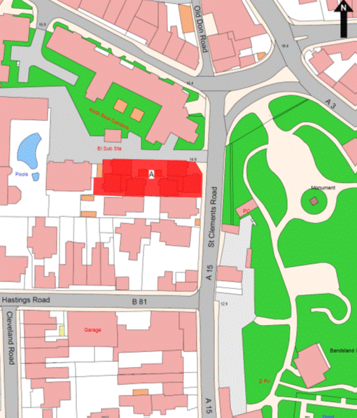
Part
56
Keith
Baal Gardens
(1) The
Property known as Keith Baal Gardens (“the Property”), as shown on the Plan in
this Part entitled “Keith Baal Gardens”, to which the public has right by the
contracts of purchase dated –
(a) 30th March 1990
(PR 880/592);
(b) 18th May 1990
(PR 883/29);
(c) 5th October 1990
(PR 889/179); and
(d) 19th October 1990
(PR 890/15),
(“Contracts of Purchase”).
(2) The
boundaries of the Property and all rights attaching thereto are as set out in –
(a) the Contracts of Purchase;
(b) in the following transactions –
(i) the Deed of Arrangement dated 6th
September 1996 (PR 1017/333), and
(ii) the contract of Lease
and Wayleave Rights by the public and The Jersey Electricity Company Limited
dated 6th September 1996 (PR 1017/417); and
(c) sub-paragraphs (3)
and (4).
(3) The
wall to the north of the Property towards Nos. 74 and 76 Colomberie
retained by the public shall be party owned between the parties.
(4) The
walls of the east, south-east and east-south-east of Nos. 74 and 76
Colomberie retained by the public towards the Property shall belong, without
offset, to the public.
NOTE:
The Property is situate in the
Parish of St. Helier in the Vingtaine du Haut de la Ville and has the
UPRN 69406013.
Keith Baal Gardens
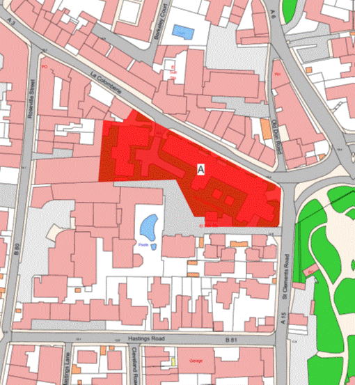
Part
57
1 and
2 Bellozanne Villas
(1) The
Property known as 1 and 2 Bellozanne Villas (“the Property”), as shown on the
Plan in this Part entitled “1 and 2 Bellozanne Villas”, to which the public has
right by contract of purchase dated 15th June 1984 (PR 780/508)
(“Contract of Purchase”).
(2) The
boundaries of the Property and all rights attaching thereto are set out in the
Contract of Purchase.
NOTE:
The Property is situate in the
Parish of St. Helier in the Vingtaine du Mont Cochon and has the
UPRN 69386479.
1 and 2 Bellozanne Villas
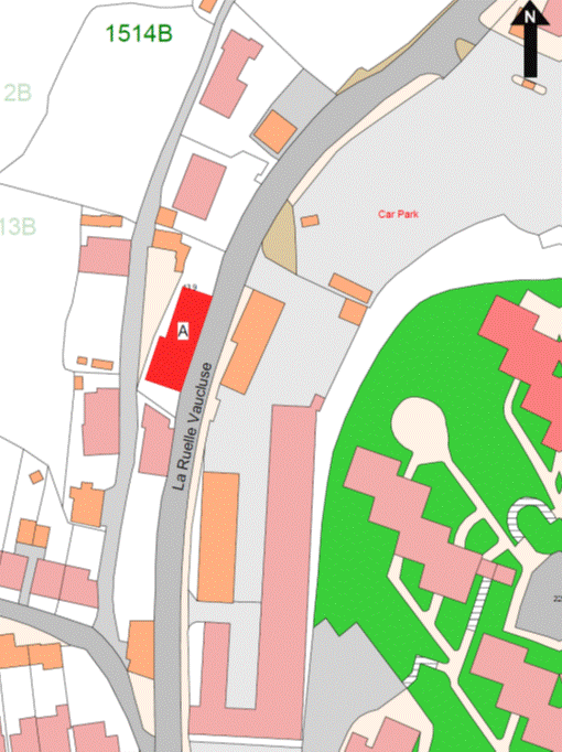
Part
58
1 and
2 Victoria Court
(1) The
properties known as 1 and 2 Victoria Court (“the Property”), as shown on the
Plan in this Part entitled “1 and 2 Victoria Court”, to which the public has
right by the contracts of purchase dated –
(a) 24th December 1949
(PR 451B/242); and
(b) 1st September 1951
(PR 454B/216),
(“Contracts of Purchase”).
(2) The
boundaries of the Property and all rights attaching thereto are set out in the
Contracts of Purchase and in the following sub-paragraph.
(3) The
wall to the south-east of the Property towards the road retained by the public
is transferred, without offset, to the company.
NOTE:
The Property is situate in the
Parish of St. Saviour in the Vingtaine de la Petite Longueville and has
the UPRN 69387155.
1 and 2 Victoria Court
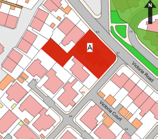
Part
59
Devonia
Close
(1) The
Property known as Devonia Close (“the Property”), as shown on the Plan in this
Part entitled “Devonia Close”, to which the public has right by the contracts
of purchase dated –
(a) 16th March 1984
(PR 776/326);
(b) 30th March 1984
(PR 777/154);
(c) 22nd June 1984
(PR 780/687);
(d) 29th April 1988
(PR 847/283);
(e) 24th June 1988
(PR 850/194);
(f) 15th July 1988
(PR 851/179); and
(g) 23rd December 1988
(PR 859/192),
(“Contracts of Purchase”).
(2) The
boundaries of the Property and all rights attaching thereto are set out in the
Contracts of Purchase and in the following deeds –
(a) Deed of Arrangement dated
28th April 1989 (PR 864/508); and
(b) Deed of Arrangement dated
2nd June 1989 (PR 866/18).
NOTE:
The Property is situate in the
Parish of St. Helier in the Vingtaine du Bas du Mont au Prêtre and has the
UPRN 69386633.
Devonia Close
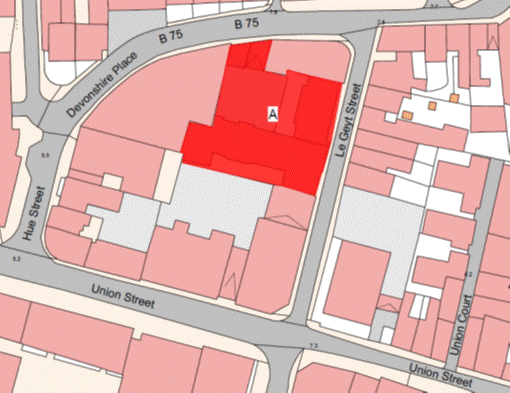
Part
60
Liberation
Court
(1) The
Property known as Liberation Court (“the Property”), as shown on the Plan in
this Part entitled “Liberation Court”, to which the public has right by the
contracts of purchase dated –
(a) 13th September 1963
(PR 482A/116);
(b) 25th May 1979 (PR 703/283);
(c) 25th August 1978
(PR 692/469);
(d) 25th May 1978
(PR 703/285); and
(e) 21st June 1991
(PR 901/542),
(“Contracts of Purchase”).
(2) The
boundaries of the Property and all rights attaching thereto are set out in the
Contracts of Purchase.
NOTE:
The Property is situate in the
Parish of St. Helier in the Vingtaine du Haut de la Ville and has the
UPRN 69002557.
Liberation Court
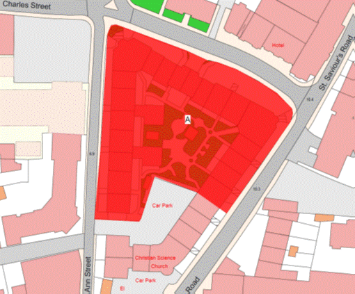
Part
61
Le Clos
de Petit Félard
(1) The
Property known as Le Clos de Petit Félard (“the Property”), as shown on
the Plan in this Part entitled “Le Clos de Petit Félard”, to which the
public has right by the contracts of purchase dated –
(a) 9th September 1988
(PR 853/598); and
(b) 9th September 1988
(PR 853/607),
(“Contracts of Purchase”).
(2) The
boundaries of the Property and all rights attaching thereto are as set out in
the Contracts of Purchase and the following contracts –
(a) Deed of Arrangement dated
7th July 1995 (PR 991/360); and
(b) Lease and Cession of
Wayleave Rights by the public to Jersey Electricity PLC dated 8th April 2011
(PR 1276/649).
NOTE:
The Property is situate in the Parish
of St. Lawrence in the Vingtaine de Bas de la Vallée and having the
UPRN 69202638.
Le Clos de Petit Félard
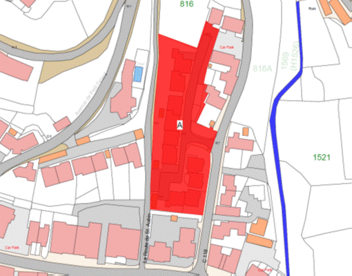
Part
62
Jardin
du Crocquet, St. Aubin
(1) The
Property known as Jardin du Crocquet (“the Property”), as shown on the Plan in
this Part entitled “Jardin du Crocquet, St. Aubin”, to which the public
has right by contract of purchase dated 20th November 1987 (PR 839/568),
(“Contract of Purchase”).
(2) The
boundaries of the Property and all rights attaching thereto are as set out in
the Contract of Purchase and in the following transactions and notice –
(a) contract between the
public and The Jersey Electricity Company Limited dated 3rd March 1989
(PR 862/405);
(b) Deed of Arrangement dated 16th
August 1991 (PR 904/447);
(c) Deed of Arrangement dated
5th June 1998 (PR 1054/267); and
(d) JEC Notice served on the
public by Jersey Electricity PLC dated 6th October 2011 (PR 1286/96).
NOTE:
The Property is situate in the
Parish of St. Brelade in the Vingtaine du Coin and has the
UPRN 69386646.
Jardin du Crocquet, St. Aubin
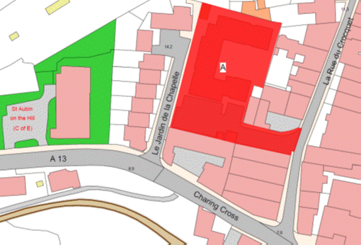
Part
63
The
Ferns
(1) The
Property known as The Ferns (“the Property”), as shown on the Plan in this Part
entitled “The Ferns”, to which the public has right by contract of purchase
dated 29th April 1939 (PR 435B/30) (“Contract of Purchase”).
(2) The
boundaries of the Property and all rights attaching thereto are as set out in
the Contract of Purchase and in the following contracts –
(a) contract of exchange and counter-exchange
dated 8th February 1974 (PR 622/178); and
(b) sale by the public dated 19th
September 1975 (PR 643/302).
NOTE:
The
Property is situate in the Parish of St. Saviour in the Vingtaine de la
Petite Longueville and has the UPRN 69002129.
The Ferns
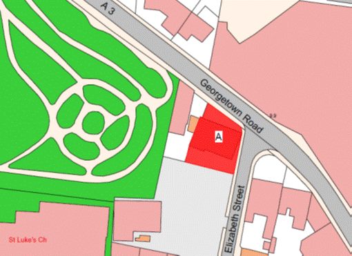
Part
64
Sherland
Close and Wyvill
(1) The
properties known as Sherland Close and Wyvill (“the Property”), as shown on the
Plan in this Part entitled “Sherland Close and Wyvill”, to which the public has
right by the contracts of purchase dated –
(a) 26th July 1968
(PR 547/592);
(b) 23rd April 1971
(PR 581/279); and
(c) 20th August 1982
(PR 748/182),
(“Contracts of Purchase”).
(2) The
boundaries of the Property and all rights attaching thereto are as set out in
the Contracts of Purchase.
NOTE:
The Property is situate in the
Parish of St. Saviour in the Vingtaine de la Petite Longueville and have
the UPRN 69386675 and 69386664.
Sherland Close and Wyvill
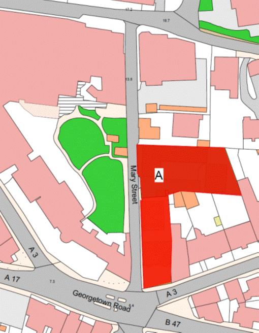
Part
65
Le Douet
Clément
(1) The
Property known as Le Douet Clément (“the Property”), as shown on the Plan
in this Part entitled “Le Douet Clément”, to which the public has right by
contract of purchase dated 20th November 1987 (PR 839/578)
(“Contract of Purchase”).
(2) The
boundaries of the Property and all rights attaching thereto are set out in the
Contract of Purchase and in the contract of Lease and Cession of Wayleave Rights
by the public to Jersey Electricity Plc dated 11th November 2011
(PR 1287/358).
NOTE:
The Property is situate in the
Parish of St. Brelade in the Vingtaine des Quennevais and has the
UPRN 69408442.
Le Douet Clément
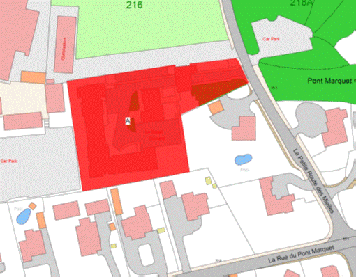
Part
66
Beau
Vallon Flats
(1) The
Property known as Beau Vallon Flats (“the Property”), as shown on the Plan in
this Part entitled “Beau Vallon Flats”, and to which the public has right by
contract of purchase dated 21st December 1990 (PR 893/218) (“Contract
of Purchase”).
(2) The
boundaries of the Property and all rights attaching thereto are as set out in
the Contract of Purchase and in the following transactions –
(a) sale by the public dated
23rd September 1994 (PR 974/125); and
(b) Deed of Arrangement dated
15th September 1995 (PR 995/587).
NOTE:
The public administers and
maintains a public foul sewer that extends from Les Vaux New Road, under
the vehicle access and through the parking area forming part of the Property to
the north-west boundary. This public sewer drains the Property and other
properties to the north-west. The public foul sewer was originally constructed
under a Royal Court notice dated 19th December 1991.
The public does not maintain or
administer any branch connections from this public sewer or any surface water
or road drainage system in the Property.
The route of the public sewer described
above is as shown on the plan in this Part entitled “Public Sewers administered
and maintained by T&TS Beau Vallon Flats”.
The Property is situate in the
Parish of St. Helier in the Vingtaine du Haut du Mont au Prêtre and has
the UPRN 69385981.
Beau Vallon Flats
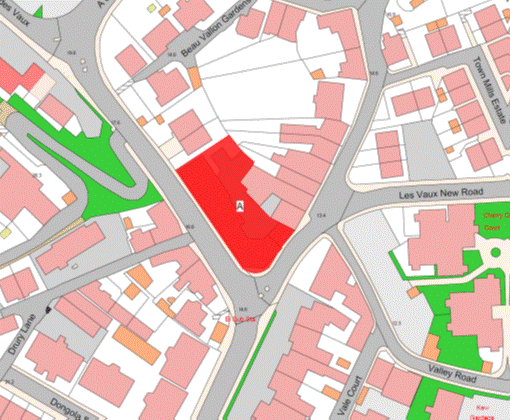
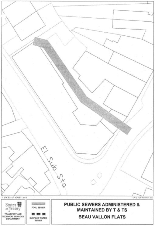
Part
67
Dennis
Ryan Court and Dennis Ryan Cottages
(1) The
properties known as Dennis Ryan Court and Dennis Ryan Cottages (“the Properties”),
as shown on the Plan in this Part entitled “Dennis Ryan Court and Dennis Ryan
Cottages”, to which the public has right by contract of purchase dated 23rd
March 1990 (PR 880/233) (“Contract of Purchase”).
(2) The
boundaries of the Properties and all rights attaching thereto are as set out in
the Contract of Purchase.
NOTE:
The Properties are situate in the
Parish of St. Helier in the Vingtaine du Mont au Prêtre and having the
UPRN 69386632 and 69386631.
Dennis Ryan Court and Dennis Ryan Cottages
Part
68
La Grande
Pièce, St. Peter
(comprising
3 Blocks of Flats and Flats 31–38)
(1) The
Property known as La Grande Pièce (“the Property”), as shown on the Plan
in this Part entitled “La Grande Pièce, St. Peter”, to which the
public has right (inter alia) by –
(a) the Contracts of Purchase
dated –
(i) 24th December 1971 (PR 592/99),
(ii) 11th May 1973
(PR 612/335),
(iii) 11th May 1973
(PR 612/339); and
(b) by way of compulsory
purchase under the Compulsory
Purchase of Land (Procedure) (Jersey) Law 1961 by Act of the Royal Court
dated 18th June 1976 (PR 654/531),
(“Contracts of Purchase”
and “Act of the Royal Court”).
(2) The
boundaries of the Property and all rights attaching thereto are set out in the Contracts
of Purchase and Act of the Royal Court and in the contracts of sale by the
public dated –
(a) 27th January 1978
(PR 682/202); and
(b) 16th March 1990
(PR 880/113).
NOTE:
The Property is situate in the
Parish of St. Peter in the Vingtaine du Douet and has the
UPRN 69002226.
La Grande Pièce, St. Peter
Part
69
Vauxhall
Gardens
(1) The
property known as Vauxhall Gardens (“the Property”), as shown on the Plan in
this Part entitled “Vauxhall Gardens”, to which the public has right by
contract of purchase dated 14th September 1984 (PR 784/200)
(“Contract of Purchase”).
(2) The
boundaries of the Property and all rights attaching thereto are as set out in
the Contract of Purchase and in the following contracts –
(a) Lease and Cession of
Wayleave Rights to The Jersey Electricty Company Limited dated 1st September 1989
(PR 870/561); and
(b) sale by the public dated 20th
December 1991 (PR 911/275).
NOTE:
The Property is situate in the
Parish of St. Helier in the Vingtaine du Bas du Mont au Prêtre and having
the UPRN 69386669.
Vauxhall Gardens
Part
70
Ralegh
House
(10 Ralegh Avenue called Summerside)
(1) The property known as Ralegh House (“the
Property”), as shown on the Plan in this Part entitled “Ralegh House”, to which
the public has right by contract of purchase dated 11th May 1979
(PR 702/686) (“Contract of Purchase”).
(2) The
boundaries of the Property and all rights attaching thereto are as set out in
the Contract of Purchase.
NOTE:
The Property is situate in the
Parish of St. Helier in the Vingtaine du Rouge Bouillon and having the
UPRN 69002597.
Ralegh House
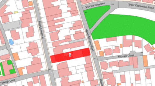
Part
71
St. Lawrence
Arsenal
(1) The
property known as St. Lawrence Arsenal (“the Property”), as shown on the
Plan in this Part entitled “St. Lawrence Arsenal”, to which the public has
right (amongst other realty) by contracts of purchase dated –
(a) 30th December 1843
(PR 183/16); and
(b) 9th March 1844 (PR 183/86),
(“Contracts of Purchase”).
(2) The
boundaries of the Property and all rights attaching thereto are as set out in –
(a) the Contracts of Purchase;
(b) the following contracts –
(i) the contract of exchange and
counter-exchange dated 19th March 1993 (PR 936/332), and
(ii) the contract of Sale and
Cession of Wayleave Rights by the public to The Jersey Electricity Company
Limited dated 4th June 1999 (PR 1078/78); and
(c) sub-paragraph (3).
(3) The
metal fence to the north, east and west of the Property towards a car parking
area used by St. Lawrence School and retained by the public shall belong,
without offset, to the public.
NOTE:
The Property is situate in the Parish
of St. Lawrence in the Vingtaine du Coin Motier and having the
UPRN 69408443.
St. Lawrence Arsenal
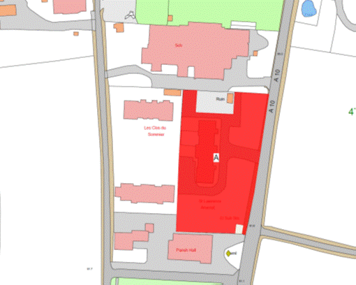
Part
72
Victoria
Cottage Homes
(1) The
Property known as Victoria Cottage Homes (“the Property”), as shown on the Plan
in this Part entitled “Victoria Cottage Homes”, to which the public has right
by the Contracts of Purchase dated –
(a) 17th December 1898
(PR 327/154); and
(b) 8th March 1968
(PR 542/172),
(“Contracts of
Purchase”).
(2) The
boundaries of the Property and all rights attaching thereto are set out in the
Contracts of Purchase and in the following Deeds of Arrangement –
(a) Deed of Arrangement dated
26th April 1985 (PR 794/261); and
(b) Deed of Arrangement dated
3rd September 2004 (PR 1174/90).
NOTE:
The Property is situate in the Parish
of St. Saviour in the Vingtaine de Sous l’Eglise and has the
UPRN 69407235.
Victoria Cottage Homes
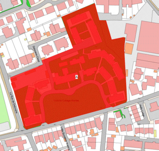
Part
73
Jane
Sandeman Court
(1) The
Property known as Jane Sandeman Court (“the Property”), as shown on the Plan in
this Part entitled “Jane Sandeman Court”, to which the public has right by the
following Contracts of Purchase dated –
(a) 6th December 1985
(PR 804/499);
(b) 22nd April 1988
(PR 847/23); and
(c) by way of compulsory
purchase under Compulsory
Purchase of Land (Procedure) (Jersey) Law 1961 from unknown owners by
Act of the Royal Court dated 17th July 1992 (PR 922/10),
(“Contracts of Purchase”
and “Act of the Royal Court”).
(2) The
boundaries of the Property and all rights attaching thereto are set out in the Contracts
of Purchase and Act of the Royal Court and in the following contracts –
(a) Deed of Arrangement dated
14th August 1992 (PR 923/314); and
(b) Cession and Transfer of
rights by the public to The Jersey Electricity Company Limited dated 16th
January 2004 (PR 1164/850).
NOTE:
The Property is situate in the
Parish of St. Helier in the Vingtaine du Rouge Bouillon and has the
UPRN 69386645.
Jane Sandeman Court
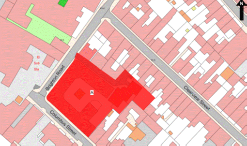
Part
74
Journeaux
Court, Brompton Villa, Homeville, 30 Aquila Road and 2 and 4 Journeaux
Street
(1) The
properties known as Journeaux Court, Brompton Villa, Homeville and 30 Aquila
Road and 2 and 4 Journeaux Street (“the Properties”), as shown on the Plan in
this Part entitled “Journeaux Court, Brompton Villa, Homeville, 30 Aquila Road
and 2 and 4 Journeaux Street”, to which the public has right by the Contracts
of Purchase dated –
(a) 14th November 1959
(PR 473C/24);
(b) 30th January 1960
(PR 472B/176);
(c) 5th March 1965
(PR 498/438);
(d) 5th March 1965
(PR 498/440);
(e) 24th September 1965
(PR 505/427);
(f) 27th October 1967
(PR 536/393);
(g) 16th January 1970
(PR 563/462);
(h) 23rd June 1972
(PR 599/53);
(i) 4th August 1972
(PR 600/438);
(j) 18th August 1972
(PR 601/69);
(k) 14th November 1975
(PR 645/438);
(l) 20th February 1976
(PR 649/513);
(m) 3rd August 1979
(PR 705/617);
(n) 2nd October 1981
(PR 733/632);
(o) 19th November 1982
(PR 752/336);
(p) 14th December 1984
(PR 788/277); and
(q) 25th July 2008
(PR 1239/384),
(“Contracts of Purchase”).
(2) The
boundaries of the Properties and all rights attaching thereto are set out in
the Contracts of Purchase and in the following transactions –
(a) Gift, Cession and
Transfer of rights by the public to The Jersey Electricity Company Limited
dated 27th March 1987 (PR 828/500); and
(b) Deed of Arrangement dated
1st August 2008 (PR 1239/570).
NOTE:
The Properties are situate in the
Parish of St. Helier in the Vingtaine du Rouge Bouillon and have the
UPRNs 69380212, 69206767, 69386643 and 69386437.
Journeaux Court, Brompton Villa, Homeville, 30 Aquila Road and 2 and
4 Journeaux Street
Part
75
Les Cinq
Chênes
(1) The
Property known as Les Cinq Chênes (“the Property”), as shown on the Plan
in this Part entitled “Les Cinq Chênes”, to which the public has right by the
Contracts of Purchase dated –
(a) 10th February 1967
(PR 526/28);
(b) 29th March 1968
(PR 543/215);
(c) 9th August 1968
(PR 548/260);
(d) 23rd May 1969
(PR 556/530);
(e) 16th July 2010 by
way of Gift, Cession and Transfer (PR 1265/721);
(f) 23rd July 2010 by
way of Gift, Cession and Transfer (PR 1265/961);
(g) 10th September 2010
by way of Gift, Cession and Transfer (exchange and counter exchange)
(PR 1267/327); and
(h) 26th November 2010
by way of Gift, Cession and Transfer (PR 1270/393),
(“Contracts of Purchase”);
and
by way of compulsory
purchase under the Compulsory
Purchase of Land (Procedure) (Jersey) Law 1961 by Act of the Royal
Court dated 18th October 1968 (PR 550/325) (“Act of the Royal
Court”).
(2) The
boundaries of the Property and all rights attaching thereto are set out in –
(a) the Contracts of Purchase
and the Act of the Royal Court;
(b) in the contract of Lease
and Cession of Wayleave Rights by the public to Jersey Electricity PLC dated 19th
March 2010 (PR 1261/774);
(c) the Deed of Arrangement
dated 1st March 2013 (PR 1308/665); and
(d) the Deed of Arrangement
dated 12th April 2013 (PR 1310/646).
NOTE:
The public administers and
maintains both public foul and surface water sewers in the Property’s roads.
The public foul and surface water sewers extend into the Property in a
north-westerly direction from La Rue des Friquettes under the vehicle
access between Nos. 96 and 106 Les Cinq Chenes and as far as the road
junction adjacent to Nos. 48 and 49 Les Cinq Chenes. They then head
in a north-easterly direction until they reach the pedestrian access adjacent
to No. 53 Les Cinq Chenes. They again head in a north-westerly
direction until they reach La Grande Route de St. Martin. A public
foul branch sewer extends to the north-west from this public foul sewer and
between Nos. 50 and 51 Les Cinq Chenes and then in a south-westerly
direction along the north-western boundaries of Nos. 50 and 49 Les Cinq
Chenes draining properties on La Grande Route de St. Martin.
Public foul and surface water
sewers extend into the Property in a north-westerly direction from Prince’s
Tower Road through the garden of No. 86 Les Cinq Chenes and extend as
far as a point between Nos. 35 and 36 Les Cinq Chenes.
Public foul and surface water
sewers also extend into the Property in a north-easterly direction from
Prince’s Tower Road under the vehicle access between Nos. 5 and 31 Les Cinq
Chenes to a point adjacent to Nos. 41 and 42 Les Cinq Chenes where
they then head in a north-westerly direction adjacent to No. 21 Les Cinq
Chenes where they turn in a south-westerly direction to a point to the rear of
Five Oaks Garage. Public branch foul and surface water sewers extend from these
public sewers in a north-westerly direction between Nos. 1 and 30 Les Cinq
Chenes and then in a south-westerly direction to a point adjacent to No. 4
Les Cinq Chenes.
The Department does not maintain
or administer any branch connections from these public sewers to the buildings within
the Property or any road drainage system in the roads forming parts of the
Property.
The route of the public sewers
described above are as shown on the plan in this Part entitled “Public Sewers
administered and maintained by T&TS Les Cinq Chenes”.
The Property is situate in the
Parish of St. Saviour in the Vingtaine des Pigneaux and has the
UPRN 69408405.
Les Cinq Chênes
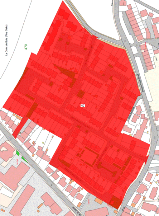
Part
76
Convent
Court
(1) The
property known as Convent Court (“the Property”), as shown on the Plan in this
Part entitled “Convent Court”, to which the public has right by the contracts
of purchase dated –
(a) 29th May 1970
(PR 568/445); and
(b) 24th January 1986
(PR 806/674),
(“Contracts of Purchase”).
(2) The
boundaries of the Property and all rights attaching thereto are as set out in
the Contracts of Purchase and in the following contracts –
(a) Deed of Arrangement dated 18th
January 1974 (PR 621/367);
(b) Lease and Cession of
Wayleave Rights by the public to The Jersey Electricity Company Limited dated
28th January 1994 (PR 958/327);
(c) sale by the public
dated 16th July 2001 (PR 1121/392); and
(d) sale by the public dated
2nd April 2004 (PR 1167/948).
NOTE:
The Property is situate in the
Parish of St. Helier in the Vingtaine du Bas du Mont au Prêtre and having
the UPRN 69403652.
Convent Court
Part
77
2
Simon Place
(1) The
property known as 2 Simon Place (“the Property”), as shown on the Plan in this
Part entitled “2 Simon Place”, to which the public has right by contract of
purchase dated 16th September 1977 (PR 675/90) (“Contract of
Purchase”).
(2) The
boundaries of the Property and all rights attaching thereto are as set out in
the Contract of Purchase.
NOTE:
The
Property is situate in the Parish of St. Helier in the Vingtaine du Haut
de la Ville and has the UPRN 69003035.
2 Simon Place
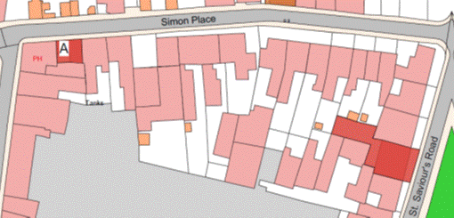
Part
78
Jack
Counter Close
(1) The
property known as Jack Counter Close (“the Property”), as shown on the Plan in
this Part entitled “Jack Counter Close”, to which the public has right –
(a) by contract of purchase
dated 11th August 1972 (PR 600/553) (“Contract of Purchase”); and
(b) by way of compulsory
purchase under Compulsory
Purchase of Land (Procedure) (Jersey) Law 1961 by Act of the Royal
Court dated 9th August 1974 (PR 628/364) (“Act of the Royal Court”).
(2) The
boundaries of the Property and all rights attaching thereto are as set out in
the Contract of Purchase and the Act of the Royal Court.
NOTE:
The Property is situate in the
Parish of St. Helier in the Vingtaine du Mont Cochon and having the
UPRN 69386644.
Jack Counter Close
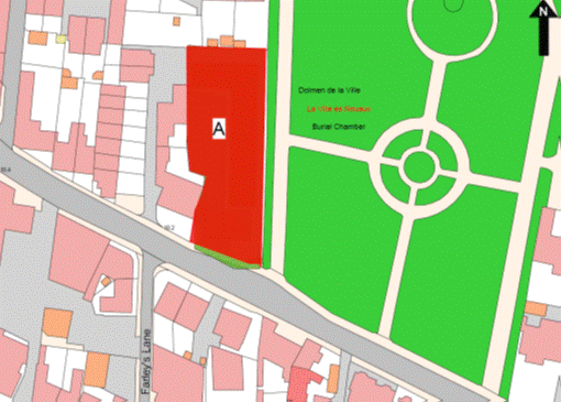
Part
79
Les Maisonettes
(1) The
property known as Les Maisonettes (“the Property”), as shown on the Plan
in this Part entitled “Les Maisonettes”, to which the public has right by
contract of purchase dated 2nd February 1968 (PR 540/534) (“Contract
of Purchase”).
(2) The
boundaries of the Property and all rights attaching thereto are as set out in
the Contract of Purchase and the contract of Lease and Wayleave Rights by the
public to Jersey Electricity Plc dated 29th July 2011 (PR 1283/79)
and in sub-paragraph (3).
(3) The
boundary of the Property on its western side towards First Tower School
retained by the public is an old stone wall which belongs, without offset, to
the public and forms part of First Tower School.
NOTE:
The Property is situate in the
Parish of St. Helier in the Vingtaine du Mont à l’Abbé and having the
UPRN 69408202.
Les Maisonettes
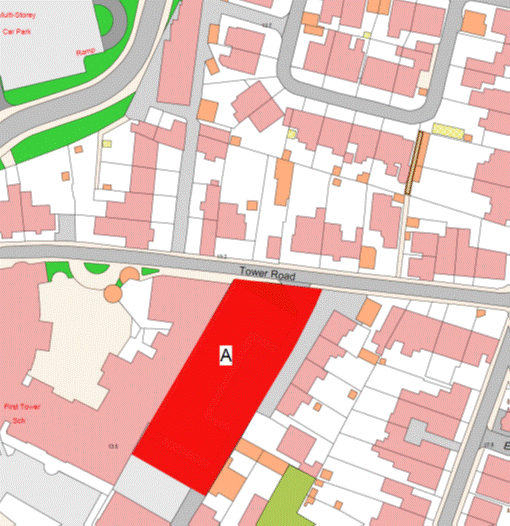
Part 80
Hillside
Court
(1) The
property known as Hillside Court (“the Property”), as shown on the Plan in this
Part entitled “Hillside Court”, to which the public has right by contract of
purchase dated 9th April 1976 (PR 651/447) (“Contract of Purchase”).
(2) The
boundaries of the Property and all rights attaching thereto are as set out in
the Contract of Purchase.
NOTE:
The Property is situate in the
Parish of St. Helier in the Vingtaine du Mont à l’Abbé and having the
UPRN 69002290.
Hillside Court
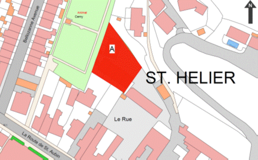
Part
81
Osborne
Court
(1) The
property known as Osborne Court (“the Property”), as shown on the Plan in this
Part entitled “Osborne Court”, to which the public has right by the contracts
of purchase dated –
(a) 1st November 1974
(PR 630/576); and
(b) 29th November 1974
(PR 631/573),
(“Contracts of Purchase”).
(2) The
boundaries of the Property and all rights attaching thereto are as set out in
the Contracts of Purchase and the following transactions –
(a) Deed of Arrangement dated
12th March 1976 (PR 650/381); and
(b) Lease and Cession of
Wayleave Rights by the public to The Jersey Electricity Company Limited dated
4th February 1994 (PR 958/514).
NOTE:
The Property is situate in the
Parish of St. Helier in the Vingtaine du Mont à l’Abbé and having the
UPRN 69002291.
Osborne Court
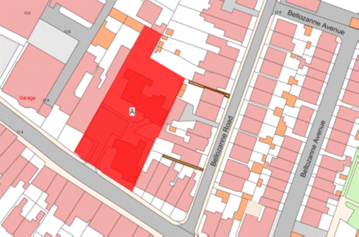
Part
82
Lord
Coutanche Court
(1) The
property known as Lord Coutanche Court (“the Property”), as shown on the Plan
in this Part entitled “Lord Coutanche Court”, to which the public has right by
the contracts of purchase dated –
(a) 27th April 1973
(PR 612/13);
(b) 29th June 1973
(PR 614/316);
(c) 7th September 1973
(PR 616/454); and
(d) 7th September 1973
(PR 616/457),
(“Contracts of Purchase”).
(2) The
boundaries of the Property and all rights attaching thereto are as set out in
the Contracts of Purchase and in the contract of Lease and Cession of Wayleave
Rights by the public to The Jersey Electricity Company Limited dated 29th
November 2002 (PR 1146/493).
NOTE:
The Property is situate in the
Parish of St. Helier in the Vingtaine de Bas de la Ville and having the
UPRN 69404799.
Lord Coutanche Court
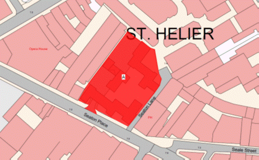
Part
83
Gorey
House
(1) The
Property known as Gorey House (“the Property”), comprising a flat and public
conveniences as shown on the Plan in this Part entitled “Gorey House”, to which
the public has had right from time immemorial.
(2) The
walls of the building forming part of the Property to the north, west and
south-west are transferred, without offset, to the company.
NOTE:
The Property is situate in the
Parish of St. Martin in the Vingtaine de Faldouet and has the
UPRN 69386640.
Gorey House
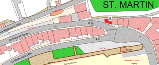
Part
84
St. Mary’s
Court
(1) The
property now known as St. Mary’s Court (“the Property”), as shown on the
Plan in this Part entitled “St. Mary’s Court”, to which the public has
right by contract of purchase dated 19th February 1982
(PR 739/541) (“Contract of Purchase”).
(2) The
boundaries of the Property and all rights attaching thereto are as set out in –
(a) the Contract of Purchase;
(b) the following transactions –
(i) Deed of Transaction and Sale dated 23rd
June 2000 (PR 1100/411),
(ii) Deed of Transaction
dated 13th January 2012 (PR 1290/107), and
(iii) Contract of Lease and
Cession of Wayleave Rights by the public to Jersey Electricity plc
dated 20th May 2011 (PR 1278/628); and
(c) sub-paragraph (3).
(3) The
boundary to the east of the Property towards the ambulance station retained by
the public is the granite wall which shall be a party owned between the
parties.
NOTE:
The Property is situate in the
Parish of St. Helier in the Vingtaine de Rouge Bouillon and has the
UPRN 69002501.
St. Mary’s Court
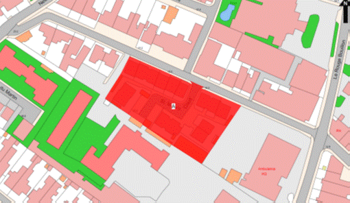
Part
85
35
Kensington Place
(1) The
property known as 35 Kensington Place (“the Property”), as shown on the Plan in
this Part entitled “35 Kensington Place”, to which the public has right by
contract of purchase dated 23rd November 1990 (PR 891/353) (“Contract
of Purchase”).
(2) The
boundaries of the Property and all rights attaching thereto are as set out in
the Contract of Purchase.
NOTE:
The Property is situate in the
Parish of St. Helier, Vingtaine de Rouge Bouillon and has the
UPRN 69108693.
35 Kensington Place
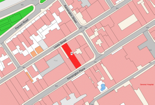
Part
86
1 and
3 Balleine Close and the private roadway Balleine Close
(1) The
2 properties known respectively as 1 and 3 Balleine Close and the private
roadway Balleine Close forming one corpus fundi
(“the Property”), as shown on the Plan in this Part entitled “1 and 3 Balleine
Close and the private roadway Balleine Close”, to which the public has right by
contract of purchase dated 13th July 1990 from the Parish of St. Clement
(PR 885/494) (“Contract of Purchase”).
(2) The
boundaries of the Property and all rights attaching thereto are as set out in –
(a) the Contract of Purchase;
(b) a Deed of Transaction
dated 26th June 1992 (PR 920/160); and
(c) the contracts of sale by
the public dated –
(i) 4th March 1994 (PR 960/239),
(ii) 7th October 1994
(PR 974/579),
(iii) 20th May 1994
(PR 965/313),
(iv) 17th October 1997
(PR 1041/53),
(v) 28th August 2009 (PR 1254/452),
(vi) 10th September 2010
(PR 1267/341),
(vii) 22nd October 2010
(PR 1268/731), and
(viii) 22nd June 2012
(PR 1297/421).
NOTE:
The Property is situate in the
Parish of St. Clement, Vingtaine de Samarès and has the
UPRN 69386463.
1 and 3 Balleine Close and the private roadway Balleine Close
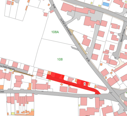
Part
87
Hue
Court
(1) The
Property known as Hue Court (“the Property”), as shown on the Plan in this Part
entitled “Hue Court”, to which the public has right by –
(a) the contracts of purchase
dated –
(i) 25th April 1969 (PR 556/78),
(ii) 13th September 1968
(PR 549/164),
(iii) 4th December 1964
(PR 495/507),
(iv) 28th July 1967
(PR 532/469),
(v) 20th September 1968 (PR 549/273),
(vi) 21st July 1967
(PR 532/329),
(vii) 25th August 1967
(PR 533/480),
(viii) 5th March 1965
(PR 498/443),
(ix) 20th November 1964
(PR 495/183),
(x) 28th December 1964 (PR 496/439),
(xi) 18th December 1964
(PR 496/221),
(xii) 10th December 1965
(PR 508/390),
(xiii) 19th November 1971
(PR 590/207),
(xiv) 22nd December 1967
(PR 539/125),
(xv) 23rd August 1968
(PR 548/427),
(xvi) 25th April 1969
(PR 556/75), and
(xvii) 15th November 1974
(PR 631/223),
(“Contracts of Purchase”), and
(b) by compulsory purchase under the Compulsory Purchase of
Land (Procedure) (Jersey) Law 1961 by the Acts of the Royal Court
dated –
(i) 22nd May 1970 (PR 568/575),
(ii) 15th November 1968
(PR 551/294),
(iii) 22nd May 1970
(PR 568/569),
(iv) 22nd May 1970
(PR 568/570), and
(v) 29th October 1971 (PR 589/578),
(“Acts of the Royal
Court”).
(2) The
boundaries of the Property and all rights attaching thereto are as set out
in –
(a) the Contracts of
Purchase;
(b) the Acts of the Royal
Court;
(c) the following
contracts –
(i) Contract of Exchange and counter exchange
dated 14th July 1978 (PR 690/583), and
(ii) Deed of arrangement
dated 18th December 1998 (PR 1067/296); and
(d) paragraphs (3), (4),
(5) and (6).
(3) The
boundary line separating the Property from the road and pavements known as “Hue
Street” retained by the Public is a line taken from the south-east corner the
most southerly of the brick edging at ground level of the bricked walkway
forming part of the Property which links Hue Street with Old Street in a
northerly direction following the eastern face of the brick edging until
reaching the southern gable of the block of apartments the most westerly of the
two high rise apartment blocks forming part of the Property.
(4) From
this point the line follows the southern face of the southern gable of the
block of apartments in an easterly direction until reaching the south-east
corner of the southern gable of the block of apartments.
(5) From
the latter corner the line is taken in an east-south-easterly direction until
reaching the imaginary point shown as BP01 on the boundary location plan bearing
the reference M891/01 in this Part and described in the Table in this Part. From
this imaginary point the line is then taken in an east-north-easterly direction
until reaching the south-east corner of the most easterly of two drainage
covers then in a northerly direction following the eastern side of the most
easterly of the two drainage covers and continuing on the same alignment until
reaching the back edge of the tarmacked pavement forming part of Hue Street.
(6) From
this point the line follows the back edge of the tarmacked pavement in an
easterly direction until reaching the south-east corner of the wall to the west
of the entrance to the basement parking area forming part of the Property. The
line is then taken from the latter mentioned south-east corner of the wall in
an easterly direction until reaching the back edge of the tarmacked pavement on
the eastern side of the entrance to the basement parking area forming part of
the Property. From this point the line follows the back edge of the tarmacked
pavement forming part of Hue Street in a north-easterly direction until
reaching Dumaresq Street.
NOTE:
The Property is situate in the
Parish of St. Helier in the Vingtaine du Bas de la Ville and have the
UPRN 69206813.
Hue Court
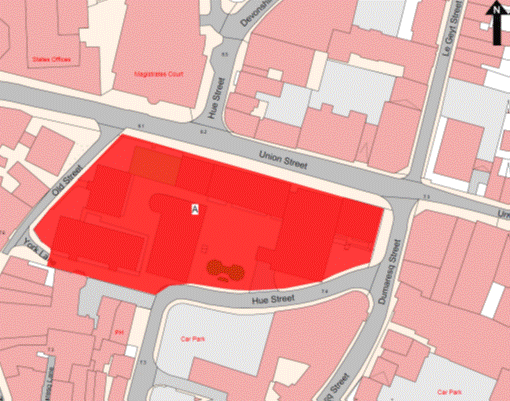
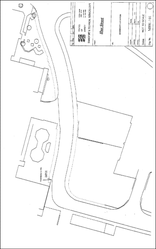
Table
|
Property known as Hue
Court, Hue Street, St. Helier
|
|
Co-ordinate and
Descriptive Definition of the Boundary Points.
The following co-ordinate listing and descriptions apply to
boundary location plan M891/01. The boundary point has co-ordinates currently
used in Jersey Map Grid System 2004.
The following coordinates represent the boundary point.
|
|
Point No.
|
Easting
|
Northing
|
Description
|
|
BP01
|
41934.65E
|
65667.44N
|
Boundary point situated on the
public footpath directly below the South Eastern corner of the overhang of Hue
Court Flats.
|
Part
88
4 Le Bernage
(1) The
property known as 4 Le Bernage (“the Property”), as shown on the Plan in
this Part entitled “4 Le Bernage”, to which the public has right by the
contracts of purchase dated –
(a) 22nd December 1989 (PR 876/161);
and
(b) 20th December 1991
(PR 911/25),
(“Contracts of Purchase”).
(2) The
boundaries of the Property and all rights attaching thereto are as set out in –
(a) the Contracts of Purchase;
(b) the contracts of sale by
the public dated –
(i) 29th July 1994 (PR 970/293),
(ii) 7th October 1994
(PR 974/563),
(iii) 23rd September 1994
(PR 973/539),
(iv) 23rd September 1994
(PR 974/110),
(v) 19th August 1994 (PR 971/469),
(vi) 12th August 1994
(PR 971/250),
(vii) 23rd September 1994
(PR 973/555),
(viii) 9th September 1994
(PR 973/122),
(ix) 9th September 1994
(PR 973/147),
(x) 9th September 1994 (PR 973/29),
(xi) 19th August 1994
(PR 971/423),
(xii) 14th October 1994
(PR 975/137),
(xiii) 9th September 1994
(PR 973/212),
(xiv) 23rd September 1994
(PR 974/138),
(xv) 26th August 1994
(PR 972/128),
(xvi) 26th August 1994
(PR 972/153),
(xvii) 9th September 1994
(PR 973/235),
(xviii) 9th September 1994
(PR 973/273),
(xix) 25th November 1994
(PR 977/309),
(xx) 9th September 1994
(PR 973/79),
(xxi) 23rd September 1994
(PR 973/572);
(xxii) 12th August 1994
(PR 971/204),
(xxiii) 26th August 1994
(PR 972/262),
(xxiv) 12th August 1994
(PR 971/185),
(xxv) 25th November 1994
(PR 977/393),
(xxvi) 26th August 1994
(PR 972/197),
(xxvii) 9th
September 1994 (PR 973/101),
(xxviii) 26th
August 1994 (PR 972/240),
(xxix) 9th
September 1994 (PR 973/256),
(xxx) 26th August 1994
(PR 972/322),
(xxxi) 2nd
September 1994 (PR 972/556),
(xxxii) 19th
August 1994 (PR 971/513),
(xxxiii) 26th
August 1994 (PR 972/112); and
(c) the
contract of arrangement dated 8th April 2011 (PR 1276/626).
NOTE:
The Property is situate in the
Parish of St. Saviour in the Vingtaine de la Petite Longueville and has
the UPRN 69122316.
4 Le Bernage
Part
89
Faux
Bié Terrace, Chestnut Court and Pine Court, St. Mark’s Gate, Le Geyt
Flats and Le Geyt Apartments, Kew Gardens, Maple Grove and Les Quatre
Bras
(1) The
properties known as Faux Bié Terrace, Chestnut Court, Pine Court,
St. Mark’s Gate, Le Geyt Flats, Le Geyt Apartments, Kew Gardens,
Maple Grove, Les Quatre Bras (“the Properties”), as shown on the Plan in this
Part entitled “Faux Bié Terrace, Chestnut Court and Pine Court, St. Mark’s
Gate, Le Geyt Flats and Le Geyt Apartments, Kew Gardens, Maple Grove
and Les Quatre Bras”, to which the public has right as follows –
(a) by way of compulsory
purchase under the Compulsory Purchase of Land (Procedure) (Jersey)
Law 1948 –
(i) by Act of the Royal Court dated 4th
March 1950 (PR 452A/58),
(ii) by 4 Acts of the Royal
Court all dated 9th April 1951 (PR 453B/284 PR 454B/3, PR 454B/10 and PR
454B/11),
(iii) by 7 Acts of the Royal
Court all dated 9th April 1951 (PR 454B/4, PR 454B/6 PR 454B/7, PR
454B/12, PR 454B/14, PR 454B/15, and PR 454B/17),
(iv) by Act of the Royal Court
dated 9th April 1951 (PR 454B/8),
(v) by Act of the Royal Court dated 11th
April 1951 (PR 454B/18),
(vi) by Act of the Royal Court
dated 11th April 1951 (PR 454B/20),
(vii) by Act of the Royal Court
dated 11th April 1951 (PR 454B/22); and
(b) the following
contracts –
(i) gift, cession and transfer dated 18th
November 1950 (PR 453C/112),
(ii) gift, cession and
transfer dated 6th September 1952 (PR 456B/225),
(iii) purchase dated 30th
April 1955 (PR 461A/250),
(iv) purchase dated 12th
November 1955 (PR 463A/25),
(v) purchase dated 28th July 1972 (PR
600/309),
(vi) purchase dated 25th
August 1972 (PR 601/213),
(vii) purchase dated 1st
March 1991 (PR 896/309),
(viii) sale, cession and transfer
by way of Exchange and Counter-Exchange dated 27th August 1993 (PR 949/1),
(ix) purchase dated 10th
January 2003 (PR 1148/96),
(x) purchase of half of brook dated 7th
October 2005 (PR 1190/689),
(xi) sale dated 6th
February 2009 (PR 1246/157),
(xii) Lease and Cession of
Wayleave Rights to The Jersey Electricity Company Limited dated 19th
December 1997 (PR 1045/252), and
(xiii) Lease and Cession of
Wayleave Rights to Jersey Electricity Plc dated 20th May 2011 (PR
1278/638),
(“the Acts of the Royal
Court and Contracts”).
(2) The
boundaries of the Properties and all rights attaching thereto are as set out
in –
(a) the Acts of the Royal
Court and Contracts; and
(b) sub-paragraph (3).
(3) The
boundaries of the Properties towards the land forming part of St. Mark’s
school retained by the public are as follows –
(a) the retaining walls to
the north, north east and east or thereabouts of the Properties towards
St. Mark’s school shall be transferred, without offset, to the company;
(b) the wall to the south of
St. Mark’s School towards the road forming part of the Properties shall
continue to belong, without offset, to the public; and
(c) the granite wall to the
west of the Properties towards the Civil Emergency building retained by the
public shall be party owned between the parties.
NOTE:
The
public administers and maintains both the public foul and surface water sewers
that lie to the east of Kew Gardens alongside the access leading to the parking
area for Pine Court then continue in a Southerly direction under the pedestrian
access to the west of Block 3 Pine Court and extend southward between Maple
Grove and Chestnut Court and then further southward between Faux Bie Terrace
and Le Geyt Apartments and Flats before entering Springfield Road.
Public branch sewers lead from
these public sewers –
(a) under
a pedestrian access to the south of Block 3 Pine Court to Le Geyt Road
where it then extends to the north;
(b) to
the west between Block D Maple Grove and Faux Bie Terrace to the Trinity
Gardens boundary;
(c) to
the east under the road heading east between Block G Chestnut Grove and
Le Geyt Apartments towards St. Mark’s Gate;
(d) to
the east to Le Geyt Road and from that point a public foul sewer only that
extends to the south to drain Salvandy Terrace; and
(e) in
Le Geyt Road to the north of Block B and west of Block C St. Mark’s
Gate.
The public does not maintain or
administer any branch connections from these sewers to the Properties or any
road drainage system in the roads or parking areas forming parts of the
Properties.
The current routes of the public
sewers described above are as shown on the plan in this Part entitled “Public
Sewers administered and maintained by T&TS Le Geyt Estate”.
The Properties are situate in the
Parish of St. Saviour in the Vingtaine de Sous l’Eglise and in the Parish
of St. Helier in the Vingtaine du Rouge Bouillon and have the UPRNs
69386637, 69385703, 69383752, 69386667, 69002383, 69002382, 69404807, 69386650
and 69002522.
Faux Bié Terrace, Chestnut Court and Pine Court, St. Mark’s
Gate, Le Geyt Flats and Le Geyt Apartments, Kew Gardens, Maple Grove
and Les Quatre Bras
Part
90
Cherry
Orchard Court and Perrée Villas
(1) The
properties known as Cherry Orchard Court and Perrée Villas (“the Properties”),
as shown on the Plan in this Part entitled “Cherry Orchard Court and Perrée
Villas”, to which the public has right by the contracts of purchase dated –
(a) 9th July 1898
(PR 326/16);
(b) 29th April 1950
(PR 452B/123);
(c) 6th May 1950
(PR 452B/138);
(d) 13th May 1950
(PR 452A/146);
(e) 21st June 1958
(PR 469C/14); and
(f) 19th July 1958
(PR 469C/66),
(“Contracts of Purchase”).
(2) The boundaries of the Properties and all
rights attaching thereto are as set out in the Contracts of Purchase and in the
contract of Lease and Cession of Wayleave Rights by the public to Jersey
Electricity Plc dated 20th May 2011 (PR 1278/638).
NOTE:
The public administers and
maintains both the public foul and surface water trunk sewers that enter the Properties
in a north-east to south-west direction from Les Vaux New Road before
heading south between Blocks B and C Cherry Orchard Court and exiting out into
Valley Road between Block B Cherry Orchard Court and Perrée Villas.
The public does not maintain or
administer any branch connections from this sewer to the properties or any road
drainage system in the Properties parking areas or parish roads.
The current routes of the public
sewers described above are as shown on the plan in this Part entitled “Public
Sewers administered and maintained by T&TS Cherry Orchard Court and Perrée
Villas”.
The Properties are situate in the
Parishes of St. Helier and St. Saviour in the Vingtaines of Haut du
Mont au Prêtre and Sous l’Eglise and have the UPRNs 69383019, 69383020 and
69386653.
Cherry Orchard Court and Perrée Villas
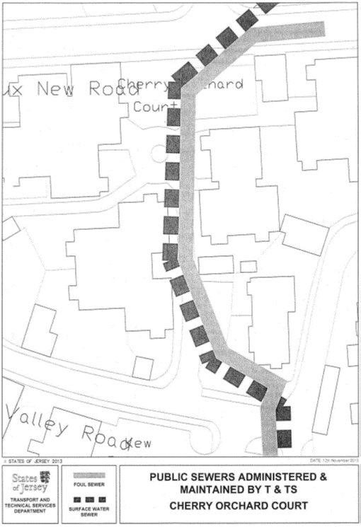
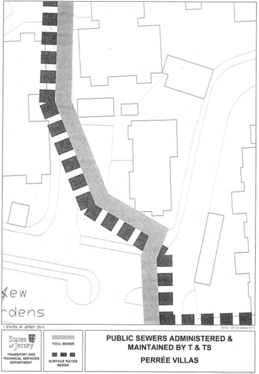
Part
91
26 The
Parade
(1) The
property known as 26 The Parade (“the Property”), as shown on the Plan in this
Part entitled “26 The Parade”, to which the public has right by contract of
purchase dated 1st December 1967 (PR 538/60) (“Contract of
Purchase”).
(2) The
boundaries of the Property and all rights attaching thereto are as set out in
the Contract of Purchase and in the contract of sale by the public dated 20th
October 2000 (PR 1106/654).
NOTE:
The Property is situate in the
Parish of St. Helier, Vingtaine du Rouge Bouillon and has the
UPRN 69003539.
26 The Parade
Part
92
No. 1
La Grande Maison
(1) The
property known as No. 1 La Grande Maison (including the Parking Area,
the Roadway, the Foul Drainage System and the Surface Water System as defined
in the contract of sale of No. 3 La Grande Maison by the Public dated 9th
December 2011 (PR 1288/773)) (“the Property”), as shown on the Plan
in this Part entitled “No. 1 La Grande Maison”, to which the public
has right (inter alia) by contract of
acquisition from the Crown dated 12th April 1878 (PR 267/266)
(“Contract of Acquisition”).
(2) The
boundaries of the Property and the rights attaching thereto are as set out in
the Contract of Acquisition and in the contracts of sale by the public
dated –
(a) 28th January 2005
(PR 1179/325);
(b) 29th July 2011
(PR 1282/816); and
(c) 9th December 2011
(PR 1288/773).
NOTE:
The Property is situate in the
Parish of St. Martin, Vingtaine du Fief de la Reine and has the
UPRN 69400232.
No. 1 La Grande Maison
Part
93
25, 27
and 29 St. James Street
(1) The
properties known as 25, 27 and 29 St. James Street (“the Properties”), as
shown on the Plan in this Part entitled “25, 27 and 29 St. James Street”,
to which the public has right by the contracts of purchase dated –
(a) 15th February 1985
(PR 790/196); and
(b) 1st June 1990
(PR 883/535),
(“Contracts of Purchase”).
(2) The
boundaries of the Properties and all rights attaching thereto are as set out in
the Contracts of Purchase.
NOTE:
The Properties are situate in the
Parish of St. Helier in the Vingtaine du Haut de la Ville and have the
UPRN 69386683.
25, 27 and 29 St. James Street
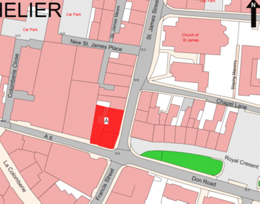
Part
94
3, 5,
7 and 9 Providence Street
(1) The
properties known as 3, 5, 7 and 9 Providence Street (“the Properties”), as
shown on the Plan in this Part entitled “3, 5, 7 and 9 Providence Street”, to
which the public has right by the contracts of purchase dated –
(a) 23rd June 1972
(PR 599/51);
(b) 10th November 1972
(PR 604/252);
(c) 11th May 1973
(PR 612/344); and
(d) 28th January 1977
(PR 664/463),
(“Contracts of Purchase”).
(2) The
boundaries of the Properties and all rights attaching thereto are as set out in
the Contracts of Purchase and in the contract of exchange and counter exchange
dated 18th July 1986 (PR 815/620).
NOTE:
The Properties are situate in the
Parish of St. Helier in the Vingtaine de Bas du Mont au Prêtre and have
the UPRN 69386682.
3, 5, 7 and 9 Providence Street
Part
95
Rose
Cottage and Lily Cottage
(1) The
properties known as Rose Cottage and Lily Cottage (“the Properties”), as shown
on the Plan in this Part entitled “Rose Cottage and Lily Cottage”, to which the
public has right by contract of purchase dated 1st July 1994
(PR 968/220) (“Contract of Purchase”).
(2) The
boundaries of the Properties and all rights attaching thereto are as set out in
the Contract of Purchase and in the contract of sale by the public dated 21st
March 1997 (PR 1029/28).
NOTE:
The Properties are situate in the
Parish of St. Helier in the Vingtaine du Haut du Mont au Prêtre and have
the UPRN 69136559 and 69136557.
Rose Cottage and Lily Cottage
Part
96
Pear
Tree House
(1) The
property known as Pear Tree House (“the Property”), as shown on the Plan in
this Part entitled “Pear Tree House”, to which the public has right by contract
of purchase dated 24th May 1991 (PR 900/243) (“Contract of Purchase”).
(2) The
boundaries of the Property and all rights attaching thereto are as set out in
the Contract of Purchase and in the contract of Cession of Wayleave Rights by
the public to The Jersey Electricity Company Limited dated 6th August 1993
(PR 947/334).
NOTE:
The Property is situate in the
Parish of St. Helier, Vingtaine de Bas du Mont-au-Prêtre and has the
UPRN 69002050.
Pear Tree House
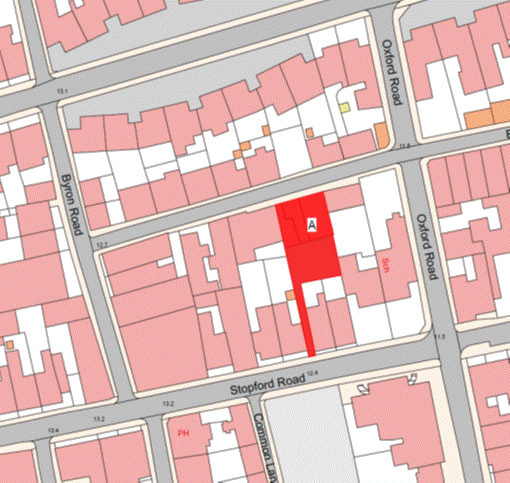
Part
97
La Carrière
Flats
(1) The
Property known as La Carrière Flats (“the Property”), as shown on the Plan
in this Part entitled “La Carrière Flats”, to which the public has right
by contract of purchase dated 17th June 1961 (PR 476C/94)
(“Contract of Purchase”).
(2) The
boundaries of the Property and all rights attaching thereto are as set out in
the Contract of Purchase.
NOTE:
The Property is situate in the
Parish of St. Helier in the Vingtaine du Haut du Mont au Prêtre and has
the UPRN 69002418.
La Carrière Flats
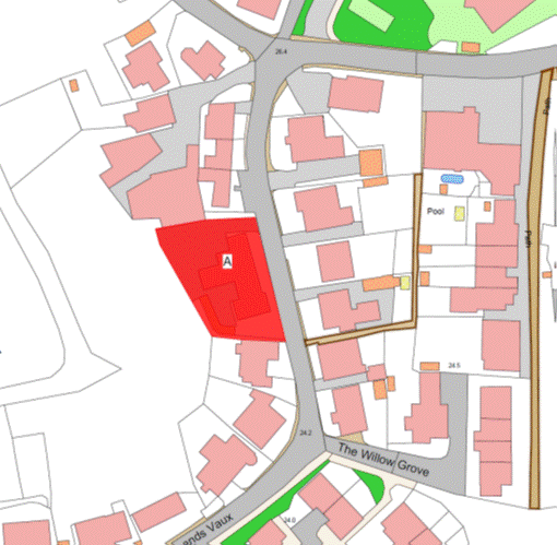
Part
98
No. 28
Great Union Road
(1) The
property known as 28 Great Union Road (also Sutton House) (“the Property”), as
shown on the Plan in this Part entitled “No. 28 Great Union Road”, to
which the public has right by contract of purchase dated 16th September 1977
(PR 675/88) (“Contract of Purchase”).
(2) The
boundaries of the Property and all rights attaching thereto are as set out in
the Contract of Purchase.
NOTE:
The Property is situate in the
Parish of St. Helier, Vingtaine de Bas du Mont-au-Prêtre and has the
UPRN 69305488.
No. 28 Great Union Road
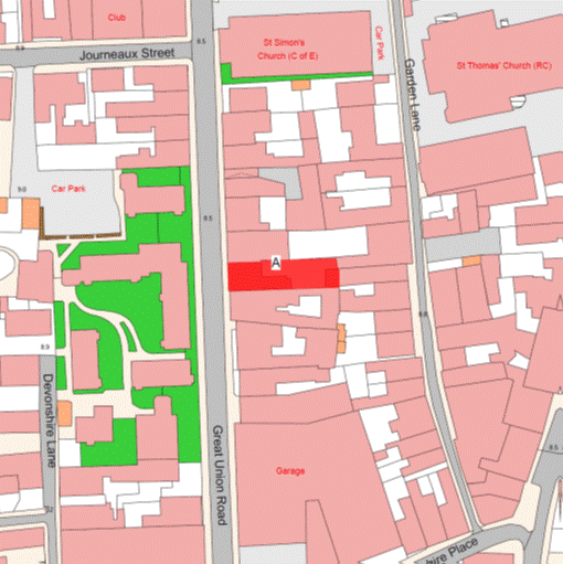
Part
99
Les
Vaux
(1) The
Property known as Les Vaux (“the Property”), as shown on the Plan in this
Part entitled “Les Vaux”, to which the public has right by contracts of
purchase dated 4th October 1985 (PR 801/282) and 6th February 1987
(PR 825/510) (“Contracts of Purchase”).
(2) The
boundaries of the Property and all rights attaching thereto are as set out in
the Contracts of Purchase.
NOTE:
The Property is situate in the
Parish of St. Saviour in the Vingtaine de Sous l’Eglise and has the
UPRN 69386648.
Les Vaux
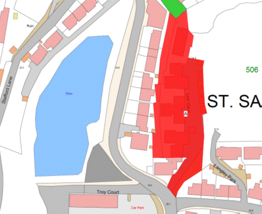
Part 100
Maison du Théatre
(1) The
Property known as Maison du Théatre (“the Property”), as shown on the Plan in
this Part entitled “Maison du Théatre”, to which the public has right by
contract of purchase dated 7th September 1984 (PR 784/25) (“Contract
of Purchase”).
(2) The
boundaries of the Property and all rights attaching thereto are as set out in
the Contract of Purchase.
NOTE:
The Property is situate in the
Parish of St. Helier in the Vingtaine du Haut de la Ville and has the
UPRN 69104820.
Maison du Théatre
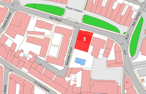
Part 101
Don Close
(1) The
Property known as Don Close (“the Property”), as shown on the Plan in this Part
entitled “Don Close”, to which the public has right by contract of purchase
dated 17th November 1972 (PR 604/451) (“Contract of Purchase”).
(2) The
boundaries of the Property and all rights attaching thereto are as set out in
the Contract of Purchase.
NOTE:
The
Property is situate in the Parish of St. Helier in the Vingtaine du Haut
de la Ville and has the UPRN 69003711.
Don Close
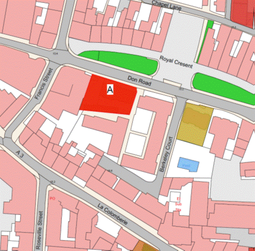
Part 102
Chapel Court
(1) The
Property known as Chapel Court (“the Property”), as shown on the Plan in this
Part entitled “Chapel Court”, to which the public has right by contract of
purchase dated 27th April 1984 (PR 778/352) (“Contract of Purchase”).
(2) The
boundaries of the Property and all rights attaching thereto are as set out in
the Contract of Purchase.
NOTE:
The Property is situate in the
Parish of St. Helier in the Vingtaine du Haut de la Ville and has the
UPRN 69002446.
Chapel Court
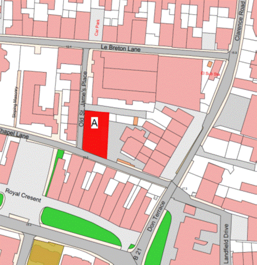
Part 103
St. Peter’s School
Estate
(1) The
Property known as St. Peter’s School Estate (“the Property”), as shown on
the Plan in this Part entitled “St. Peter’s School Estate”, to which the
public has right by contract of purchase dated 19th February 1949
(PR 450A/52) (“Contract of Purchase”).
(2) The
boundaries of the Property and all rights attaching thereto are as set out in
the Contract of Purchase.
NOTE:
The Property is situate in the
Parish of St. Peter in the Vingtaine de Douet and has the
UPRN 69380080.
St. Peter’s School Estate
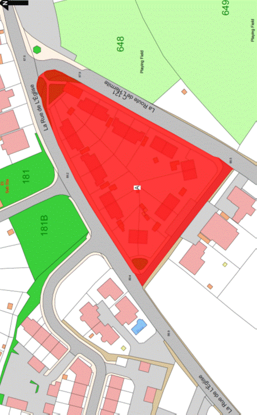
Part 104
St. Peter’s Arsenal
(1) The
Property known as St. Peter’s Arsenal (“the Property”), as shown on the
Plan in this Part entitled “St. Peter’s Arsenal”, to which the public has
right by the contracts of purchase dated –
(a) 26th November 1842
(PR 180/94);
(b) 19th February 1949
(PR 450A/52); and
(c) 17th March 1951 (PR 453C/263),
(“Contracts of Purchase”).
(2) The
boundaries of the Property and all rights attaching thereto are as set out in
the Contracts of Purchase and in the contract of Lease and Cession of Wayleave
Rights by the public to Jersey Electricity Plc dated 8th April 2011
(PR 1276/661).
NOTE:
The Property is situate in the
Parish of St. Peter in the Vingtaine de Douet and has the
UPRN 69382464.
St. Peter’s Arsenal
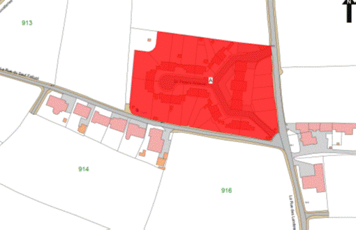
Part 105
Le Clos de L’Eglise
(1) The
Property known as Le Clos de l’Eglise (“the Property”), as shown on the
Plan in this Part entitled “Le Clos de L’Eglise”, to which the public has
right by contract of purchase dated 26th August 1939 (PR 435A/206)
(“Contract of Purchase”).
(2) The
boundaries of the Property and all rights attaching thereto are as set out in
the Contract of Purchase and in the contract of Lease and Cession of Wayleave Rights
by the public to The Jersey Electricity Company Limited dated 22nd March 1996
(PR 1007/459).
(3) The
wall to the north-east of the Property towards the property retained by the
public shall be party owned between the parties and a boundary line shall be
taken from the centre of the south eastern end of the wall in a south easterly
direction along the same alignment as the centre of the party owned wall until
reaching the south-eastern boundary of the Property.
NOTE:
The public administers and
maintains a public foul sewer that enters the Property from Field 265 adjacent
to No. 13 Le Clos de l’Eglise and crosses through the gardens of
Nos. 13 to 15 Le Clos de l’Eglise before heading in a north-easterly
direction under the gardens and the vehicle access to the Property and then
joining the public foul sewer in La Rue des Fonds.
The public does not maintain or
administer any branch connections from this sewer to the buildings forming
parts of the Property or any surface water or road drainage system in the
Property.
The current routes of the public
sewers described above are as shown on the plan in this Part entitled “Public
Sewers administered and maintained by T&TS Le Clos de L’Eglise”.
The Property is situate in the
Parish of Grouville in the Vingtaine des Marais and has the UPRN 69407293.
Le Clos de L’Eglise
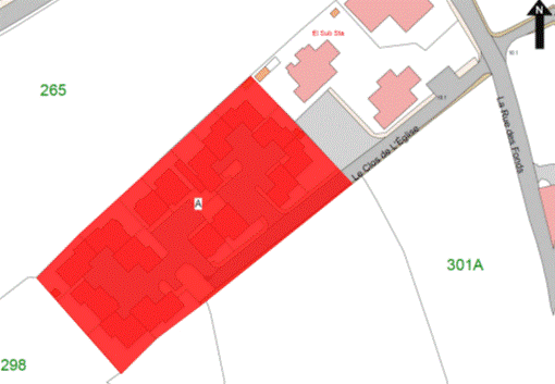
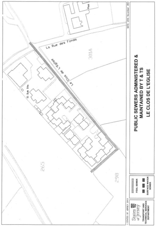
Part 106
63 Great Union Road
(1) The
Property known as 63 Great Union Road (“the Property”), as shown on the Plan in
this Part entitled “63 Great Union Road”, to which the public has right by the
contract of purchase dated 25th May 1984 (PR 779/483) (“Contract of
Purchase”).
(2) The
boundaries of the Property and all rights attaching thereto are as set out in
the Contract of Purchase.
NOTE:
The Property is situate in the
Parish of St. Helier, Vingtaine de Rouge Bouillon and has the
UPRN 69207607.
63 Great Union Road
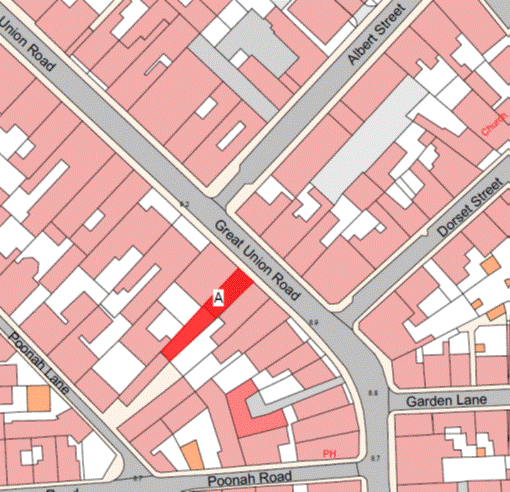
Part 107
Le Pré de Talbot
(1) The
Property known as Le Pré de Talbot (“the Property”), as shown on the Plan
in this Part entitled “Le Pré de Talbot”, to which the public has right by
contract of purchase dated 24th July 1948 (PR 449C/2) (“Contract of
Purchase”).
(2) The
boundaries of the Property and all rights attaching thereto are as set out in
the Contract of Purchase and in the following transactions –
(a) the contract of sale by
the public dated 19th December 2003 (PR 1164/434); and
(b) the Lease and Cession of
Wayleave Rights by the public to Jersey Electricity Plc dated 8th
April 2011 (PR 1276/672).
(3) The
walls and fences of the south and the east of the Property towards the land
retained by the public shall be transferred, without offset, to the company.
NOTE:
The Property is situate in the
Parish of St. Saviour in the Vingtaine de la Petite Longueville and has
the UPRN 69386658.
Le Pré de Talbot
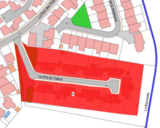
Part 108
St. Thomas’ Villas
(1) The
Property now known as St. Thomas’ Villas (“the Property”), as shown on the
Plan in this Part entitled “St. Thomas’ Villas”, to which the public has
right by the contracts of purchase dated –
(a) 22nd March 1991
(PR 897/238); and
(b) 21st June 1991
(PR 901/548),
(“Contracts of Purchase”).
(2) The
boundaries of the Property and all rights attaching thereto are as set out in
the Contracts of Purchase and in the following deeds –
(a) Deed of Arrangement dated 19th
January 1996 (PR 1004/108); and
(b) Deed of Transaction dated
10th March 2000 (PR 1095/88).
NOTE:
The Property is situate in the
Parish of St. Helier, Vingtaine de Bas du Mont-au-Prêtre and has the
UPRN 69002604.
St. Thomas’ Villas
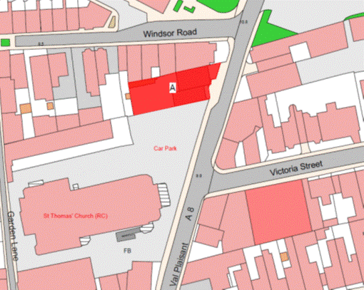
Part 109
60 Rouge Bouillon and 1 and
2 Brighton Lane Mews
(1) The
properties known as 60 Rouge Bouillon and 1 and 2 Brighton Lane Mews and
forming one corpus fundi (“the Property”), as
shown on the Plan in this Part entitled “60 Rouge Bouillon and 1 and 2 Brighton
Lane Mews”, to which the public has right by contract of purchase dated 22nd
February 1991 (PR 896/18) (“Contract of Purchase”).
(2) The
boundaries of the Property and all rights attaching thereto are as set out in
the Contract of Purchase.
NOTE:
The
Property is situate in the Parish of St. Helier in the Vingtaine du Rouge
Bouillon and has the UPRN 69002487 and 69386481.
60 Rouge Bouillon and 1 and 2 Brighton Lane Mews
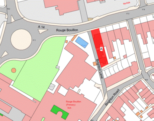
Part 110
33 Belmont Road
(1) The
Property known as No. 33 Belmont Road (“the Property”), as shown on the
Plan in this Part entitled “33 Belmont Road”, and to which the public has right
by the contracts of purchase dated –
(a) 3rd December 1960
(PR 476B/38); and
(b) 30th August 1968
(PR 548/546),
(“Contracts of Purchase”).
(2) The
boundaries of the Property and all rights attaching thereto are as set out in
the Contracts of Purchase.
NOTE:
The public administers a public
foul sewer, the old town brook Le Faux Bie that crosses under the extreme
north boundary of the Property at the pedestrian access onto Tunnell Street and
flows in a north to south direction from that road through and under
No. 32 Belmont Road.
The public does not maintain or
administer any branch connections from this sewer to the Property.
The public also administers a
large public surface water tunnel that lies in bedrock at a depth of approximately 20
metres and flows in a north-east to south-west direction across the northern
boundaries of both Nos. 33 and 34 Belmont Road.
The current routes of the public
sewers described above are as shown on the plan in this Part entitled “Public
Sewers administered and maintained by T&TS 33-34 Belmont Road”.
The Property is situate in the
Parish of St. Helier in the Vingtaine de Haut de la Ville and has the
UPRN 69002036.
33 Belmont Road
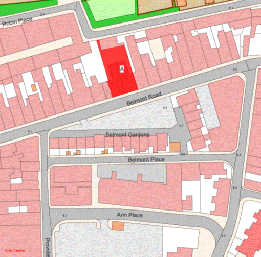
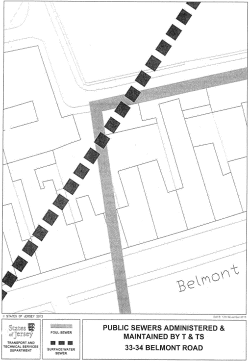
Part 111
Moreland House (aka No. 40
Great Union Road) and 29 Garden Lane
(1) The
properties known as Moreland House (40 Great Union Road) and No. 29 Garden
Lane forming one corpus fundi (“the
Property”), as shown on the Plan in this Part entitled “Moreland House (aka No. 40
Great Union Road) and 29 Garden Lane”, to which the public has right by the
contracts of purchase dated –
(a) 20th October 1945
(PR 442B/15); and
(b) 7th March 1980
(PR 713/541),
(“Contracts of Purchase”).
(2) The
boundaries of the Property and all rights attaching thereto are as set out in
the Contracts of Purchase and in the Deed of Arrangement dated 2nd October 1987
(PR 837/151).
NOTE:
The Property is situate in the
Parish of St. Helier in the Vingtaine de Bas du Mont-au-Prêtre and has the
UPRN 69306067 and 69002136.
Moreland House (aka No. 40 Great Union Road) and 29 Garden Lane
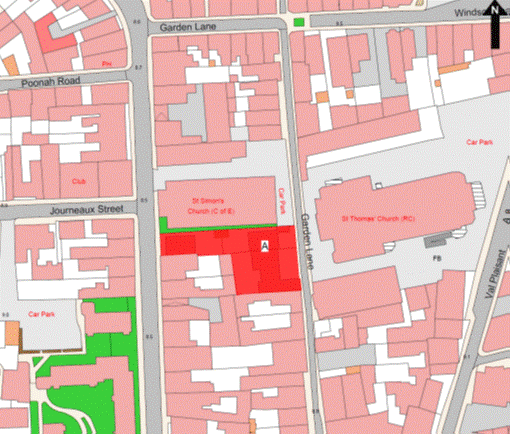
Part 112
Nos. 4 and 6 Lempriere
Street
(1) The
properties known as Nos. 4 and 6 Lemprière Street forming one corpus fundi (“the Properties”), as shown on the
Plan in this Part entitled “Nos. 4 and 6 Lempriere Street”, to which the
public has right by the contracts of purchase dated –
(a) 13th January 1962
(PR 477C/133); and
(b) 31st August 1990
(PR 887/471),
(“Contracts of Purchase”).
(2) The
boundaries of the properties and all rights attaching thereto are as set out in
the Contracts of Purchase.
NOTE:
The Properties are situate in the
Parish of St. Helier in the Vingtaine de Bas du Mont-au-Prêtre and have
the UPRN 69127272 and 69127275.
Nos. 4 and 6 Lempriere Street

Part 113
11 Simon Place
(1) The
property known as 11 Simon Place (“the Property”), as shown on the Plan in this
Part entitled “11 Simon Place”, to which the public has right by contract of
purchase dated 8th September 1978 (PR 693/156) (“Contract of
Purchase”).
(2) The
boundaries of the Property and all rights attaching thereto are as set out in
the Contract of Purchase.
NOTE:
The
Property is situate in the Parish of St. Helier in the Vingtaine du Bas du
Mont-au-Prêtre and has the UPRN 69106005.
11 Simon Place
Part 114
17 Simon Place
(1) The
property known as 17 Simon Place (“the Property”), as shown on the Plan in
this Part entitled “17 Simon Place”, to which the public has right by the
contracts of purchase dated –
(a) 18th November 1961
(PR 478A/193); and
(b) 11th May 1979
(PR 702/683),
(“Contracts of Purchase”).
(2) The
boundaries of the Property and all rights attaching thereto are as set out in
the Contracts of Purchase.
NOTE:
The public administers and
maintains the old town brook, Le Grand Douet, a public foul sewer that
runs under the western boundary of the Property in a north to south direction
from Tunnell Street to Simon Place.
The public does not maintain or
administer any branch connections from this sewer to the adjacent properties.
The current route of the public
sewer described above is as shown on the plan in this Part entitled “Public
Sewers administered and maintained by T&TS 17 Simon Place”.
The Property is situate in the
Parish of St. Helier in the Vingtaine de Haut de la Ville and has the
UPRN 69002515.
17 Simon Place
Part 115
No. 40 Aquila Road
(1) The
property known as 40 Aquila Road (“the Property”), as shown on the Plan in this
Part entitled “No. 40 Aquila Road”, to which the public has right by
contract of purchase dated 19th December 1975 (PR 647/182)
(“Contract of Purchase”).
(2) The
boundaries of the Property and all rights attaching thereto are as set out in
the Contract of Purchase and in the Deed of Arrangement dated 12th October 1984
(PR 785/380).
NOTE:
The Property is situate in the
Parish of St. Helier, Vingtaine de Rouge Bouillon and has the
UPRN 69002008.
No. 40 Aquila Road
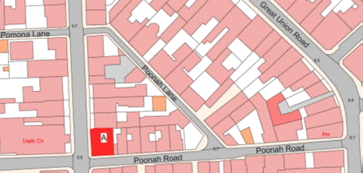
Part 116
Hampshire Gardens and 33
Poonah Road
(1) The
properties now known as Hampshire Gardens and 33 Poonah Road forming one corpus fundi (“the Property”), as shown on the Plan
in this Part entitled “Hampshire Gardens and 33 Poonah Road”, to which the
public has right by the –
(a) contracts of purchase dated –
(i) 30th May 1980 (PR 716/381),
(ii) 6th June 1980
(PR 716/503),
(iii) 28th March 1969
(PR 555/197),
(iv) 22nd October 1971
(PR 588/452),
(v) 18th November 1983 (PR 771/1),
(vi) 15th May 1970
(PR 568/188),
(vii) 24th May 1968
(PR 545/405),
(viii) 27th September 1968
(PR 549/386),
(ix) 10th May 1968
(PR 545/44),
(x) 24th May 1968 (PR 545/399),
(xi) 1st November 1968
(PR 550/487),
(xii) 14th July 1972
(PR 599/541),
(xiii) 22nd April 1961
(PR 476C/38),
(xiv) 24th May 1968
(PR 545/401),
(xv) 22nd April 1961
(PR 476C/38),
(xvi) 7th July 1962
(PR 480B/82),
(xvii) 28th May 1976 (PR 653/392),
(xviii) 19th March 1982
(PR 740/650),
(xix) 10th February 1978
(PR 682/559) (Contracts of Purchase); and
(b) by way of compulsory
purchase under the Compulsory
Purchase of Land (Procedure) (Jersey) Law 1961 by Act of the Royal Court
dated 5th January 1973 (PR 606/495) (“Act of the Royal Court”).
(2) The
boundaries of the Property and all rights attaching thereto are as set out in
the Contracts of Purchase Lease and Act of the Royal Court and in the following
contracts –
(a) sale by the public dated
14th August 1987 (PR 835/146);
(b) sale, cession and
transfer of rights by the public dated 12th June 1998 (PR 1054/390);
and
(c) Lease and Cession of Rights
by the public to Jersey Electricity Plc dated 14th June 2013
(PR 1313/552).
NOTE:
The Property is situate in the
Parish of St. Helier, Vingtaine du Rouge Bouillon and has the
UPRN 69404818 and 69002465.
Hampshire Gardens and 33 Poonah Road
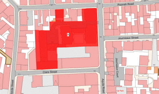
Part 117
Beren Gaed, St. Saviour’s
Road, St. Helier
(1) The
property known as Beren Gaed (“the Property”), as shown on the Plan in this
Part entitled “Beren Gaed, St. Saviour’s Road, St. Helier”, to which
the public has right by contract of purchase dated 4th September 1981 (PR
732/540) (“Contract of Purchase”).
(2) The
boundaries of the Property and all rights attaching thereto are as set out in
the Contract of Purchase and in sub-paragraph (3).
(3) The
concrete kerbs and wall towards Woodville Avenue retained by the public shall
be transferred, without offset, to the company.
NOTE:
The
Property is situate in the Parish of St. Helier in the Vingtaine de Haut
de la Ville and has the UPRN 69386624.
Beren Gaed, St. Saviour’s Road, St. Helier
Part 118
51 Garden Lane
(1) The
property known as 51 Garden Lane (“the Property”), as shown on the Plan in this
Part entitled “51 Garden Lane”, to which the public has right by contract of
purchase dated 29th October 1965 (PR 506/595) (“Contract of
Purchase”).
(2) The
boundaries of the Property and all rights attaching thereto are as set out in
the Contract of Purchase.
NOTE:
The Property is situate in the
Parish of St. Helier in the Vingtaine du Bas du Mont-au-Prêtre and has the
UPRN 69106005.
51 Garden Lane
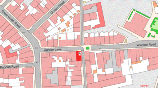
Part 119
26 and 28 West Park Avenue
(1) The
properties known as No. 26 and No. 28 West Park Avenue, forming one corpus fundi, (“the Property”), as shown on the
Plan in this Part entitled “26 and 28 West Park Avenue”, to which the public
has right by the contracts of purchase dated –
(a) 20th December 1974
(PR 632/461); and
(b) 3rd March 1978
(PR 683/551),
(“Contracts of Purchase”).
(2) The
boundaries of the Property and all rights attaching thereto are as set out in
the Contracts of Purchase and in the 125 Year Contract Lease by the public
dated 19th March 2010 (PR 1261/672).
NOTE:
The
Property is situate in the Parish of St. Helier, in the Vingtaine du Rouge
Bouillon and has the UPRN 69002626 and 69383748.
26 and 28 West Park Avenue
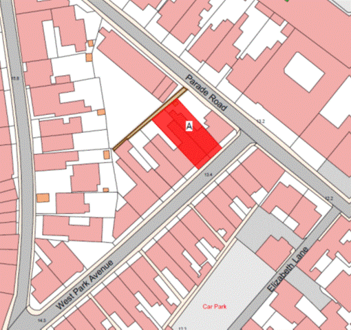
Part 120
Le Clos du Martin
(1) The
property known as Le Clos du Martin (“the Property”), as shown on the Plan
in this Part entitled “Le Clos du Martin”, to which the public has right
by contract of purchase dated 11th November 1983 (PR 770/448)
(“Contract of Purchase”).
(2) The
boundaries of the Property and all rights attaching thereto are as set out in
the Contract of Purchase and in the following transactions –
(a) Deed of Transaction dated
10th July, 1998 (PR 1056/88);
(b) Cession of Wayleave
Rights by the public to The Jersey Electricity Company Limited dated 14th
January 2000 (PR 1092/141); and
(c) Deed of Transaction dated
23rd June 2000 (PR 1100/411).
NOTE:
The
Property is situate in the Parish of St. Helier in the Vingtaine de Rouge
Bouillon and has the UPRN 69380236.
Le Clos du Martin
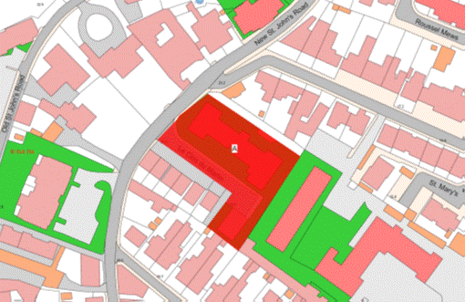
Part 121
Maesteg House, 26 and 28
Columbus Street
(1) The
properties known as Maesteg House, 26 and 28 Columbus Street and forming one corpus fundi (“the Property”), as shown on the Plan
in this Part entitled “Maesteg House, 26 and 28 Columbus Street”, to which the
public has right by the contracts of purchase dated –
(a) 4th May 1979
(PR 702/541);
(b) 3rd October 1980
(PR 720/622); and
(c) 12th January 2001
(PR 1110/485),
(“Contracts of Purchase”).
(2) The
boundaries of the Property and all rights attaching thereto are as set out in
the Contracts of Purchase.
NOTE:
The Property is situate in the
Parish of St. Helier in the Vingtaine du Rouge Bouillon and has the
UPRN 69386649 and 69386679.
Maesteg House, 26 and 28 Columbus Street
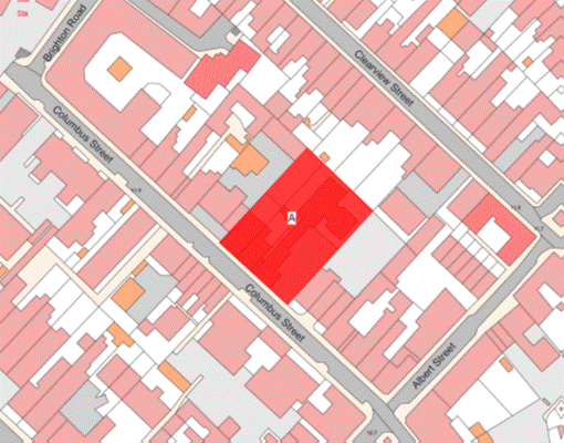
Part 122
Normandy Cottages
(1) The
properties known as Normandy Cottages and forming one corpus fundi (“the Property”), as shown on the Plan
in this Part entitled “Normandy Cottages”, to which the public has right by the
contracts of purchase dated –
(a) 5th August 1977
(PR 673/453);
(b) 5th August 1977
(PR 673/445);
(c) 5th August 1977
(PR 673/441); and
(d) 21st July 1978
(PR 691/18),
(“Contracts of Purchase”).
(2) The
boundaries of the Property and all rights attaching thereto are as set out in
the Contracts of Purchase.
NOTE:
The Property is situate in the
Parish of St. Helier in the Vingtaine du Rouge Bouillon and has the
UPRN 69386652.
Normandy Cottages
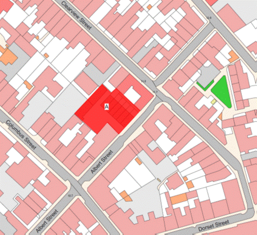
Part 123
Nicolle Close
(1) The
property now known as Nicolle Close (“the Property”), as shown on the Plan in
this Part entitled “Nicolle Close”, to which the public has right by contract
of purchase dated 29th August 1975 (PR 642/417) (“Contract of
Purchase”).
(2) The
boundaries of the Property and all rights attaching thereto are as set out in
the Contract of Purchase and in sub-paragraph (3).
(3) The
wall to the north of the Property towards the public car park retained by the
public shall be transferred, without offset, to the company.
NOTE:
The Property is situate in the
Parish of St. Helier in the Vingtaine du Bas du Mont-au-Prêtre and has the
UPRN 69002069.
Nicolle Close
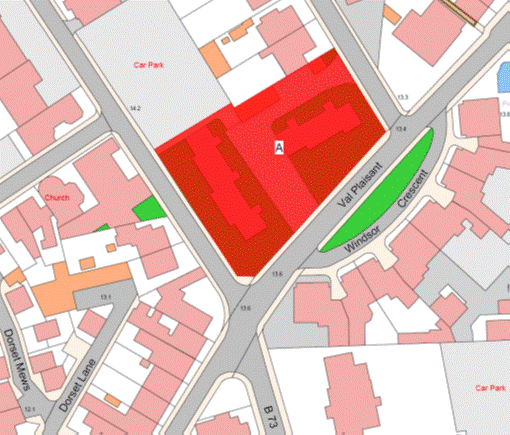
Part 124
30 Stopford Road (aka 2
Temple Villas)
(1) The
property known as 30 Stopford Road and 2 Temple Villas (“the Property”), as
shown on the Plan in this Part entitled “30 Stopford Road (aka 2 Temple Villas)”,
to which the public has right by contract of purchase dated 5th April 1983
(PR 759/630) (“Contract of Purchase”).
(2) The
boundaries of the Property and all rights attaching thereto are as set out in
the Contract of Purchase.
NOTE:
The Property is situate in the
Parish of St. Helier in the Vingtaine du Bas du Mont-au-Prêtre and has the
UPRN 69135298.
30 Stopford Road (aka 2 Temple Villas)
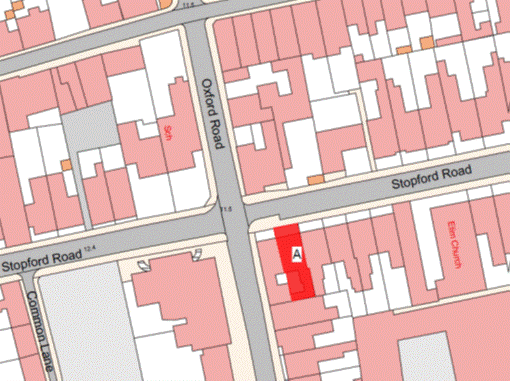
Part 125
Stopford Court
(1) The
Property known as Stopford Court (“the Property”), as shown on the Plan in this
Part entitled “Stopford Court”, and to which the public has right by Contract
of Purchase dated 12th July 1991 (PR 902/557) (“Contract of
Purchase”).
(2) The
boundaries of the Property and all rights attaching thereto are set out in the
Contract of Purchase.
NOTE:
The Property is situate in the
Parish of St. Saviour in the Vingtaine de Sous l’Eglise and having the
UPRN 69386665.
Stopford Court
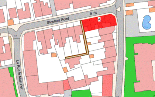
Part 126
Wellington Park
(1) The
Property known as Wellington Park (“the Property”), as shown on the Plan in
this Part entitled “Wellington Park”, and to which the public has right by
Contract of Purchase dated 6th July 1935 (PR 426/94) (“Contract of
Purchase”).
(2) The
boundaries of the Property and all rights attaching thereto are as set out in –
(a) the Contract of Purchase
and in the contract of cession and transfer by the public dated 25th April 1953
(PR 458C/30); and
(b) sub-paragraphs (3)
and (4).
(3) The
boundary to the East of the Property towards the playing fields forming part of
Hautlieu School and retained by the public is the wooden fences which shall be
transferred, without offset, to the company.
(4) The
boundary to the North and North-West towards the roadway leading to Highlands
College and retained by the public is the fences and walls which shall be
transferred, without offset, to the company.
NOTE:
The public administers and
maintains the main public foul and surface water sewers under the parish roads
and the foul sewer that runs through the rear gardens of Nos. 54 to 51
Wellington Park in an east to west direction.
The public does not maintain or
administer any branch connection from these sewers to the properties or any
road drainage system in the roads within the Property.
The current routes of the public
sewers described above are as shown on the plan in this Part entitled “Public
Sewers administered and maintained by T&TS Wellington Park”.
The Property is situate in the
Parish of St. Saviour in the Vingtaine de Sous l’Eglise and having the
UPRN 69217636.
Wellington Park
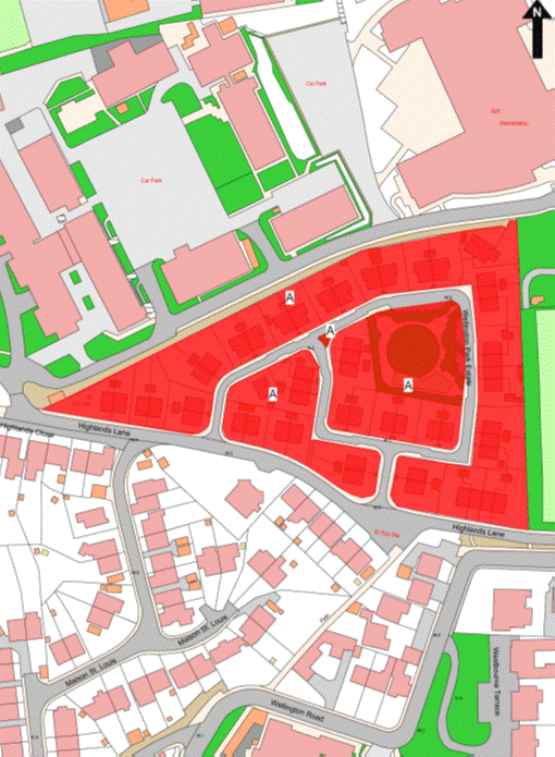
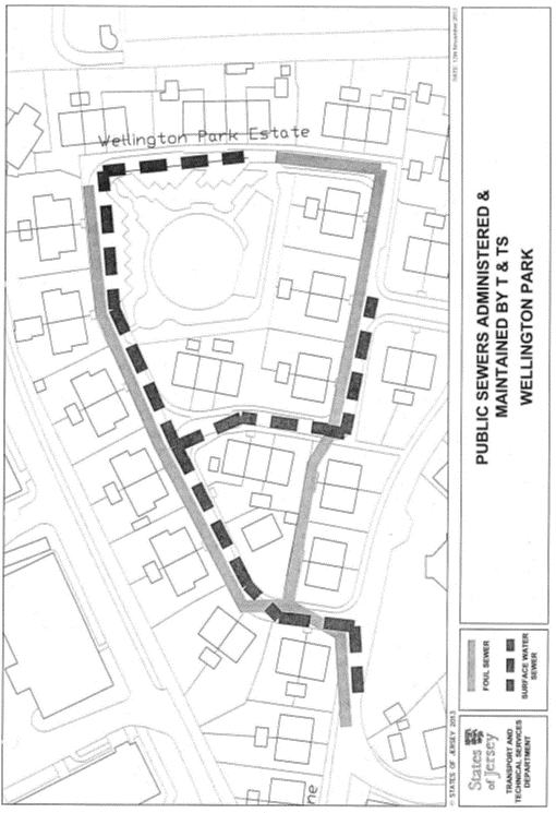
Part 127
Grouville Arsenal
(1) The
Property known as Grouville Arsenal (“the Property”), as shown on the Plan in
this Part entitled “Grouville Arsenal”, and to which the public has right by
Contract of Purchase dated 19th November 1842 (PR 180/87)
(“Contract of Purchase”).
(2) The
boundaries of the Property and all rights attaching thereto are as set out in
the Contract of Purchase and in the contract of sale by the public dated 10th
October 2008 (PR 1242/383).
NOTE:
The
public administers and maintains the public foul sewer under the roads forming
parts of the Property which public sewer enters from la Rue a Don and lies in a
north-easterly direction to the original arsenal building. A branch public
sewer extends from this point to the north-west, to the westerly corner of that
building. The main public sewer extends to the south-east and then to the
north-east adjacent to the most easterly corner of the arsenal building.
The public does not maintain or
administer any branch connection from these public sewers to the buildings or
any road drainage system in the roads forming parts of the Property.
The current routes of the public
sewers described above are as shown on the plan in this Part entitled “Public
Sewers administered and maintained by T&TS Grouville Arsenal”.
The Property is situate in the
Parish of Grouville in the Vingtaine de Longueville and having the
UPRN 69201784.
Grouville Arsenal
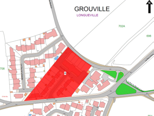
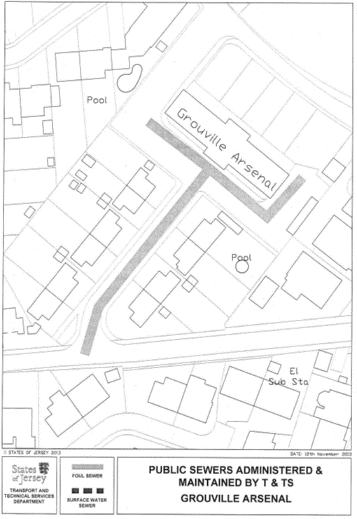
Part 128
2 Devonshire Place
(1) The
property known as 2 Devonshire Place (“the Property”), as shown on the Plan in
this Part entitled “2 Devonshire Place”, and to which the public has right by
contract of purchase dated 19th March 1965 (PR 499/119)
(“Contract of Purchase”).
(2) The
boundaries of the Property and all rights attaching thereto are as set out in
the Contract of Purchase and in the following deeds –
(a) Deed of Arrangement dated
7th August 1981 (PR 731/689); and
(b) Deed of Arrangement dated
24th October 2007 (PR 1243/21).
NOTE:
The Property is situate in the
Parish of St. Helier in the Vingtaine du Bas du Mont-au-Prêtre and has the
UPRN 69104549.
2 Devonshire Place
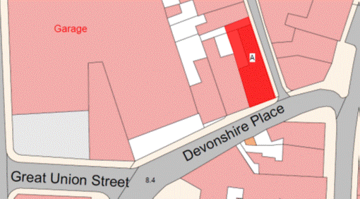
Part 129
3, 5, 7 and 7a Wesley
Street
(1) The
properties known as Numbers 3, 5, 7 and 7a Wesley Street and forming one corpus fundi (“the Property”), as shown on the Plan
in this Part entitled “3, 5, 7 and 7a Wesley Street”, and to which the public
has right by the contracts of purchase dated –
(a) 8th June 1990
(PR 884/93);
(b) 27th April 1984
(PR 778/352); and
(c) 29th June 1990
(PR 885/182),
(“Contracts of Purchase”).
(2) The
boundaries of the Property and all rights attaching thereto are as set out in
the Contracts of Purchase and in the following transactions –
(a) Deed of Arrangement dated
12th February 1993 (PR 934/368);
(b) Deed of Arrangement dated
12th April 1996 (PR 1008/473);
(c) sale by the public dated
21st November 2003 (PR 1162/768);
(d) sale by the public dated
8th June 2001 (PR 1119/511); and
(e) Lease and Cession of
Wayleave Rights by the public to The Jersey Electricity Company Limited dated
25th July 2003 (PR 1157/587).
NOTE:
The
Property is situate in the Parish of St. Helier in the Vingtaine du Haut
de la Ville and has the UPRN 69312122.
3, 5, 7 and 7a Wesley Street
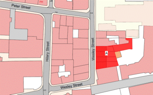
Part 130
Le Clos de Balmain and
the roadway known as Roussel Mews (previously Dummy Lane)
(1) The
property now known as Le Clos de Balmain and the roadway known as Roussel
Mews (formerly known as Dummy Lane) forming one corpus
fundi (“the Property”), as shown on the Plan in this Part entitled
“Le Clos de Balmain and the roadway known as Roussel Mews (previously
Dummy Lane)”, to which the public has right –
(a) by contract of purchase
dated 12th August 1988 (PR 852/642) (“Contract of Purchase”); and
(b) by –
(i) compulsory purchase under the Compulsory Purchase of
Land (Procedure) (Jersey) Law 1961 by Act of the Royal Court dated
22nd May 1970 (PR 568/561), and
(ii) compulsory purchase
under the Compulsory
Purchase of Land (Procedure) (Jersey) Law 1961 from unknown owners by
Act of the Royal Court dated 18th July 1986 (PR 816/459),
(“Acts of the Royal
Court”).
(2) The
boundaries of the Property and all rights attaching thereto are as set out in
the Contract of Purchase and Acts of the Royal Court and in the following
contracts –
(a) sale by the public dated 17th
October 1980 (PR 721/409); and
(b) Lease and Cession of
Wayleave Rights by the public to The Jersey Electricity Company Limited dated
13th March 1987 (PR 827/642).
NOTE:
The public administers and
maintains public foul and surface water sewers in the road known as Roussel
Mews forming part of the Property. These public sewers extend to the north from
Roussel Street to a point adjacent to Nos. 23 and 25 Le Clos de
Balmain.
The public maintains and
administers all branch connections from these sewers to the adjacent properties
to the eastern and western boundaries of 2 Roussel Mews.
The current routes of the public
sewers described above are as shown on the plan in this Part entitled “Public
Sewers administered and maintained by T&TS Clos de Balmain”.
The Property is situate in the Parish
of St. Helier in the Vingtaine du Rouge Bouillon and has the
UPRN 69386627 and 69386635.
Le Clos de Balmain and the roadway known as Roussel Mews
(previously Dummy Lane)
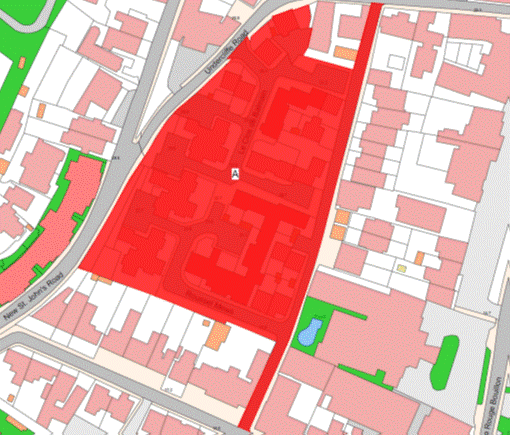
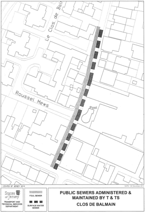
Part 131
Le Verger Flats,
Parade Road
(1) The
property known as Le Verger Flats (“the Property”), as shown on the Plan
in this Part entitled “Le Verger Flats, Parade Road”, to which the public
has right by the contracts of purchase dated –
(a) 9th July 1982
(PR 746/255);
(b) 7th July 1989
(PR 867/615); and
(c) 7th July 1989
(PR 867/611),
(“Contracts of Purchase”).
(2) The
boundaries of the Property and all rights attaching thereto are as set out in
the Contracts of Purchase and in the following contracts –
(a) sale by the public dated
9th November 1984 (PR 786/561); and
(b) Lease and Cession of
Wayleave Rights by the public to the Jersey Electricity Company Limited dated
15th May 1992 (PR 918/88).
NOTE:
The Property is situate in the
Parish of St. Helier in the Vingtaine du Rouge Bouillon and has the
UPRN 69002455.
Le Verger Flats, Parade Road
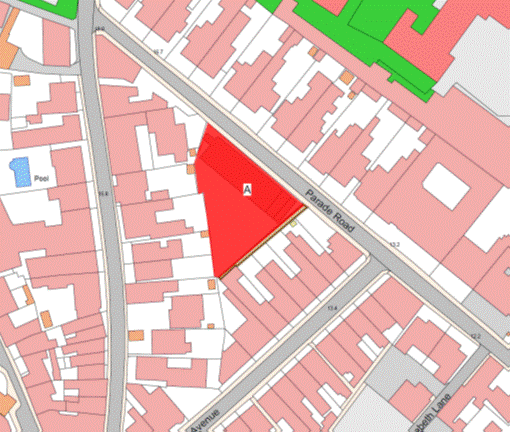
Part 132
Winchester Court
(1) The
Property known as Winchester Court (“the Property”), as shown on the Plan in
this Part entitled “Winchester Court”, to which the public has right by the
Contracts of Purchase dated –
(a) 17th September 1982
(PR 749/252); and
(b) 11th March 1994
(PR 960/274),
(“Contracts of Purchase”).
(2) The
boundaries of the Property and all rights attaching thereto are set out in the
Contracts of Purchase.
NOTE:
The
Property is situate in the Parish of St. Helier in the Vingtaine du Bas du
Mont au Prêtre having the UPRN 69002635.
Winchester Court
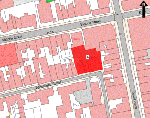
Part 133
La Collette Flats and
Bingham Court
(1) The
properties known as La Collette Flats, Bingham Court and the Multiple
Scelerosis Therapy Centre (“the Properties”), as shown on the Plan in this Part
entitled “La Collette Flats and Bingham Court”, forming one corpus fundi and to which the public has right by
the Contracts of Purchase dated –
(a) 1st March 1958
(PR 467C/267);
(b) 27th January 1962
(PR 477C/162);
(c) 18th February 1983
(PR 757/466);
(d) 18th July 1986
(PR 815/596); and
(e) 22nd March 1996
(PR 1007/303),
(“Contracts of Purchase”).
(2) The
boundaries of the Properties and all rights attaching thereto are as set out in –
(a) the Contracts of Purchase;
and
(b) the contract of sale by
the public dated 15th April 2011 (PR 1277/293); and
(c) sub-paragraph (3).
(3) The
boundaries of the Properties towards the Centre Point Trust Nursery (“the
Nursery”) retained by the Public are as follows –
The wall to the south or thereabouts
of the sloping footpath leading to the Nursery, the wooden fences to the east
and south or thereabouts of the Nursery and the walls to the east and south or
thereabouts shall continue to belong, without offset, to the public.
NOTE:
The public administers and
maintains a public foul sewer in Rope Walk that drains through the Properties
to the south-east between Bingham Court and Block D La Collette Flats and
then in an easterly direction to the north of Blocks F and E La Collette
Flats before connecting to the public foul sewer in Green Street.
The public also administers and
maintains a public surface water sewer in Rope Walk that drains through the
Properties to the east between Block B and Block A La Collette Flats,
before connecting to the public surface water sewer in Green Street.
The public does not maintain or
administer any branch connection from these sewers to the Properties or any
road drainage system in the roads forming parts of the Properties.
The routes of the public sewers
described above are as shown on the plan in this Part entitled “Public Sewers
administered and maintained by T&TS La Collette Flats”.
The Properties are situate in the
Parish of St. Helier in the Vingtaines de Bas du Mont-au-Prêtre and Haut
de la Ville and have the UPRN 69383874 and 69206972.
La Collette Flats and Bingham Court
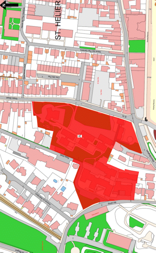
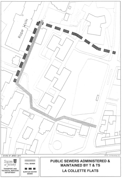
Part 134
Clos du Val and Albert
Villas
(1) The
properties now known as Clos du Val and Albert Villas forming one corpus fundi (‘the Property’), as shown on the Plan
in this Part entitled “Clos du Val and Albert Villas”, to which the public has
right by the contracts of purchase dated –
(a) 21st June 1985
(PR 796/428);
(b) 30th November 1984
(PR 787/449);
(c) 29th June 1984
(PR 781/209);
(d) 12th November 1965
(PR 507/326);
(e) 15th November 1985
(PR 803/602);
(f) 17th October 1986
(PR 820/630); and
(g) 14th December 1990
(PR 892/568),
(“Contracts of Purchase”).
(2) The
boundaries of the Property and all rights attaching thereto are as set out in
the Contracts of Purchase and in the following contracts –
(a) sale by the public dated
2nd April 2004 (PR 1167/945); and
(b) Lease and Cession of
Wayleave Rights to Jersey Electricity Plc dated 20th May 2011
(PR 1278/654).
NOTE:
The Property is situate in the
Parish of St. Helier, partly in the Vingtaine de Rouge Bouillon and partly
in the Vingtaine du Bas du Mont-au-Prêtre and has the UPRN 6938640 and
69401107.
Clos du Val and Albert Villas
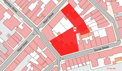
Part 135
6 Hilary Street
(1) The
property known as 6 Hilary Street (“the Property”), as shown on the Plan in
this Part entitled “6 Hilary Street”, to which the public has right by contract
of purchase dated 3rd March 1995 (PR 983/1) (“Contract of Purchase”).
(2) The
boundaries of the Property and all rights attaching thereto are as set out in
the Contract of Purchase.
NOTE:
The Property is situate in the
Parish of St. Helier, Vingtaine du Bas du Mont-au-Prêtre and has the
UPRN 69107909.
6 Hilary Street
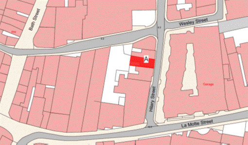
Part 136
Vincent Court and St. Simon’s
Court
(1) The
properties now known as Vincent Court and St. Simon’s Court forming one corpus fundi (“the Property”), as shown on the Plan
in this Part entitled “Vincent Court and St. Simon’s Court”, to which the
public has right by the contracts of purchase dated –
(a) 11th February 1977
(PR 665/123);
(b) 12th July 1985
(PR 797/421);
(c) 14th September 1984
(PR 784/198);
(d) 12th July 1985
(PR 797/418);
(e) 18th October 1985
(PR 802/109);
(f) 11th August 1978
(PR 692/103);
(g) 15th February 1980
(PR 712/683);
(h) 17th July 1981
(PR 731/119);
(i) 12th April 1991
(PR 898/239); and
(j) 1st November 1991
(PR 908/216),
(“Contracts of Purchase”).
(2) The
boundaries of the Property and all rights attaching thereto are as set out in
the Contracts of Purchase and in the contract of Lease and Cession of Wayleave
Rights by the public to The Jersey Electricity Company Limited dated 30th June 1989
(PR 867/520).
NOTE:
The Property is situate in the
Parish of St. Helier, Vingtaine du Rouge Bouillon and has the
UPRN 69386670 and 69002161.
Vincent Court and St. Simon’s Court
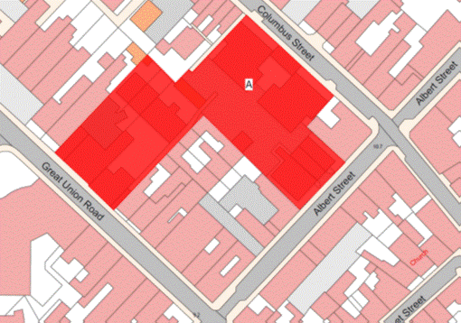
Part 137
29 Columbus Street
(1) The
property known as 29 Columbus Street (‘the Property’), as shown on the Plan in
this Part entitled “29 Columbus Street”, to which the public has right by
contract of purchase dated 31st October 1980 (PR 721/688) (“Contract
of Purchase”).
(2) The
boundaries of the Property and all rights attaching thereto are as set out in
the Contract of Purchase and in the Deed of Arrangement dated 10th October 1997
(PR 1040/503).
NOTE:
The Property is situate in the
Parish of St. Helier, Vingtaine du Rouge Bouillon and has the
UPRN 69003102.
29 Columbus Street
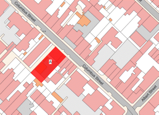
Part 138
Dorset Mews, Clearview
Place, 1 and 2 Brighton Cottages and 10, 14, 16, 18 and 20
Clearview Street
(1) The
properties known as Dorset Mews, Clearview Place, 1 and 2 Brighton Cottages and
10, 14, 16, 18 and 20 Clearview Street forming one corpus fundi (“the Property”), as shown on the Plan
in this Part entitled “Dorset Mews, Clearview Place, 1 and 2 Brighton Cottages
and 10, 14, 16, 18 and 20 Clearview Street”, to which the public
has right by the contracts of purchase dated –
(a) 12th October 1984
(PR 785/333);
(b) 29th July 1977
(PR 673/227);
(c) 5th September 1980
(PR 719/585);
(d) 17th May 1974
(PR 625/346);
(e) 7th April, 1972
(PR 596/249);
(f) 11th March 1966
(PR 511/352);
(g) 6th March 1970
(PR 565/301);
(h) 20th October 1972
(PR 603/99);
(i) 23rd May 1975
(PR 638/239);
(j) 31st May 1968
(PR 545/557);
(k) 21st February 1975
(PR 634/515);
(l) 1st April 1975
(PR 636/244);
(m) 18th July 1969
(PR 558/302);
(n) 17th March 1978
(PR 684/345); and
(o) 29th September 1967
(PR 535/43),
(“Contracts of Purchase”).
(2) The
boundaries of the Property and all rights attaching thereto are as set out in
the Contracts of Purchase and in the following contracts –
(a) sale by the public dated
7th April 1995 (PR 986/233);
(b) sale by the public dated
14th May 1982 (PR 743/397);
(c) sale by the public dated
30th November 2007 (PR 1228/394); and
(d) Exchange and Counter
Exchange dated 26th September 1980 (PR 720/388).
NOTE:
The Property is situate in the
Parish of St. Helier, Vingtaine du Rouge Bouillon and has the
UPRN 69386634 and 69386625.
Dorset Mews, Clearview Place, 1 and 2 Brighton Cottages and 10, 14, 16, 18
and 20 Clearview Street
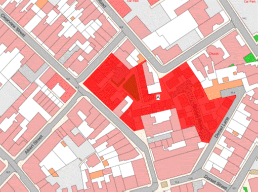
Part 139
Caesarea Court, 12, 12a,
14, 14a, 16, 18, 20, 38 and 40 Dorset Street and 9, 11, 13, 15, 17, 19,
21, 21a and 21b Windsor Road
(1) The
properties known as Caesarea Court and Nos. 12, 12a, 14,
14a, 16, 18, 20, 38 and 40 Dorset Street and Nos. 9, 11,
13, 15, 17, 19, 21, 21a and 21b Windsor Road forming one corpus fundi (“the Property”), as shown on the Plan
in this Part entitled “Caesarea Court, 12, 12a, 14, 14a, 16, 18, 20,
38 and 40 Dorset Street and 9, 11, 13, 15, 17, 19, 21, 21a and 21b
Windsor Road”, to which the public has right by the contracts of purchase dated –
(a) 6th November 1970
(PR 574/404);
(b) 9th February 1968
(PR 541/92);
(c) 13th October 1967
(PR 535/544);
(d) 10th November 1967
(PR 537/140);
(e) 11th September 1987
(PR 836/94);
(f) 27th May 1988
(PR 849/14);
(g) 21st May 1965
(PR 501/367);
(h) 10th February 1967
(PR 526/24);
(i) 23rd September 1961
(PR 478B/97);
(j) 17th December 1965
(PR 508/532);
(k) 14th October 1966
(PR 521/290);
(l) 11th August 1956
(PR 464B/144);
(m) 7th August 1964
(PR 491/463);
(n) 15th May 1964
(PR 489/3);
(o) 22nd December 1967
(PR 539/123);
(p) 10th March 1972
(PR 595/12);
(q) 10th March 1972
(PR 595/15);
(r) 25th March 1966
(PR 512/122);
(s) 26th November 1965
(PR 508/42);
(t) 19th February 1965
(PR 498/172);
(u) 22nd April 1966
(PR 513/331);
(v) 18th March 1966
(PR 511/510);
(w) 12th February 1965
(PR 498/94);
(x) 12th February 1965
(PR 498/92);
(y) 17th November 1967
(PR 537/334);
(z) 17th October 1969
(PR 560/573);
(aa) 3rd November 1967
(PR 536/537);
(ab) 2nd August 1968
(PR 548/128);
(ac) 7th January 1966
(PR 509/337); and
(ad) 1st April 1966
(PR 512/354),
(“Contracts of Purchase”).
(2) The
boundaries of the Property and all rights attaching thereto are as set out in
the Contracts of Purchase and in the following transactions –
(a) Cession of Wayleave
Rights by the public to The Jersey Electricity Company Limited dated 19th
July 1991 (PR 903/263); and
(b) sale by the public dated 18th
February 1983 (PR 757/613).
NOTE:
The
public administers and maintains a public surface water trunk sewer that lies
under Caesarea Court and drains from Dorset Street, adjacent to No. 31
Dorset Street, extending in a southerly direction through Caesarea Court before
turning in a south-easterly direction under the north-western area of the
children’s play area and connecting to the main public surface water tunnel in
Val Plaisant.
The public does not maintain or
administer any branch connections from this sewer or any other drainage system
within the Property.
The current routes of the public
sewers described above are as shown on the plan in this Part entitled “Public
Sewers administered and maintained by T&TS Caesarea Court”.
The Property is situate in the
Parish of St. Helier in the Vingtaine du Bas du Mont-au-Prêtre and has the
UPRN 69407253.
Caesarea Court, 12, 12a, 14, 14a, 16, 18, 20, 38 and
40 Dorset Street and 9, 11, 13, 15, 17, 19, 21, 21a and 21b Windsor
Road
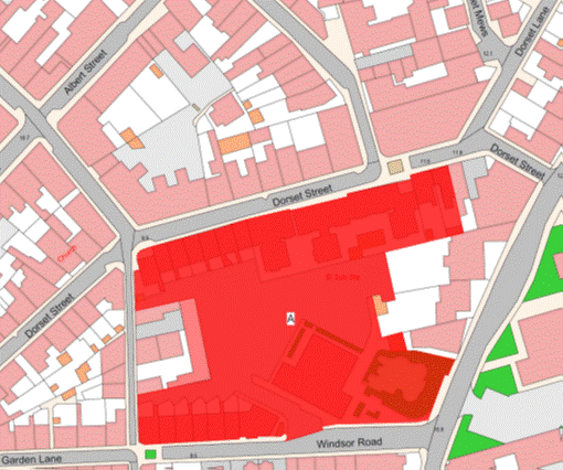
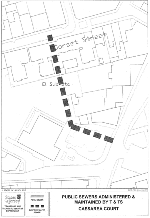
Part 140
Nicholson Close, Pillar
Gardens, Sutton Court, Whiteley Close and Wilkes Gardens
(1) The
Property known as Nicholson Close, Pillar Gardens, Sutton Court, Whiteley Close
and Wilkes Gardens forming one corpus fundi
(“the Property”), as shown on the Plan in this Part entitled “Nicholson Close,
Pillar Gardens, Sutton Court, Whiteley Close and Wilkes Gardens”, to which the
public has right by the contracts of purchase dated –
(a) 1st September 1951
(PR 454B/215);
(b) 27th July 1990
(PR 886/196); and
(c) 12th March 1965
(PR 499/4),
(“Contracts of Purchase”).
(2) The
boundaries of the Property and all rights attaching thereto are as set out in –
(a) the Contracts of Purchase;
(b) the contract of Lease and
Cession of Wayleave Rights by the public to The Jersey Electricity Company
Limited dated 19th December 1997 (PR 1045/260); and
(c) sub-paragraph (3).
(3) The
boundaries towards the land retained by the public are as follows –
(a) the wall of the
south-east or thereabouts from the southern corner of the Property until
reaching the eastern corner of the north eastern wall of No. 12 Whiteley
Close towards land retained by the public shall be transferred, without offset,
to the company;
(b) a boundary line taken
from the eastern corner of the north eastern wall of No. 12 Whiteley Close
in a south easterly direction until reaching the western corner of the wooden
fence forming part of Les Vaux Community Centre;
(c) the wooden fence and
granite wall to the north-west or thereabouts of Les Vaux Community Centre
shall continue to belong, without offset, to the public;
(d) a boundary line taken
from the north eastern corner of the northern end of the concrete lintel on top
of and forming part of the granite wall mentioned in clause (c) in an
easterly direction until reaching the north western corner of the concrete kerb
on the opposite side of the road leading up to Les Vaux Community Centre;
(e) the low retaining wall to
the west of the Property, shall be transferred, without offset, to the company;
(f) the metal fence to the
west on 3 sections and to the south on 2 sections shall be transferred,
without offset, to the company;
(g) a boundary line taken
from the south-eastern corner (the most southerly) in a north easterly
direction until reaching the south-western corner of the granite wall to the
south or thereabouts of the Property;
(h) the granite wall to the
south or thereabouts of the Property, shall be transferred, without offset, to
the company;
(i) the 2 pillars and line
of bricks separating the path forming the northern side of the property at its
eastern end with the tarmaced path running along the eastern side of Willow
Grove and the fence to the North of the Property towards the tarmaced path,
which shall be transferred, without offset, to the company.
NOTE:
The
public administers and maintains a large public surface water culvert that
drains the Grands Vaux catchment and Jersey Water reservoir to the north. This
enters the Property from Willow Grove between Nos. 11 and 12 Pillar
Gardens and heads in a south-westerly direction to a point to the north of
No. 31 Pillar Gardens where the culvert heads in a westerly direction
under the ball court and playground area draining in a south-westerly direction
to the rear of Nos. 12 to 15 Whiteley Close and to the south-east of
No. 16 Whiteley Close and crosses the play area adjacent to No. 4
Sutton Court flowing in a south-westerly direction. The culvert then crosses to
the rear of Nos. 5 and 6 Sutton Court before entering the car parking area
to the south-west of the latter then to the south-east of Nos. 17
to 20 Wilkes Gardens and 24 to 29 Wilkes Gardens draining in a
south-westerly direction until it reaches a point adjacent to No. 29
Wilkes Gardens where it heads in a north-westerly direction between that
property and the Old Coach House Apartments where it again turns to the
south-west before crossing the Grands Vaux road and entering the pond to the
south-west.
The public administers and
maintains the public foul sewer that lies under the southern footway of
Les Grands Vaux which possibly passes across the boundary of the Property.
The public also administers and
maintains a public foul sewer that enters the Property from Les Grands
Vaux under the vehicle access to Whiteley Close and then flows in a
south-easterly direction entering Sutton Court between No. 18 Sutton Court
and No. 21 Whiteley Close and runs in a south-west direction before
entering Wilkes Gardens between Nos. 12 and 13 Wilkes Gardens and follows
the road until reaching a point adjacent to No. 1 Wilkes Gardens where the
sewer turns in a southerly direction before entering into Les Grands Vaux
road. A small branch sewer heads off in a north-westerly direction from the
point adjacent to No. 1 Wilkes Gardens to drain a property at the foot of
Stafford Lane.
The public does not maintain or
administer any branch connections from these sewers to the buildings within the
Property or any road drainage system in the roads or parking areas forming
parts of the Property.
The routes of the public sewers
described above are as shown on the plans in this Part entitled “Public Sewers
administered and maintained by T&TS Nicholson Close”, “Public Sewers
administered and maintained by T&TS Pillar Gardens”, “Public Sewers
administered and maintained by T&TS Sutton Court”, “Public Sewers
administered and maintained by T&TS Whiteley Close”, and “Public Sewers
administered and maintained by T&TS Wilkes Gardens”.
The Property is situate partly in
the Parish of St. Helier in the Vingtaine du Haut du Mont au Prêtre and
partly in the Parish of St. Saviour in the Vingtaine de Sous l’Eglise and
has the UPRNs 69386651, 69408193, 69386668, 69386671 and 693886672.
Nicholson Close, Pillar Gardens, Sutton Court, Whiteley Close and
Wilkes Gardens
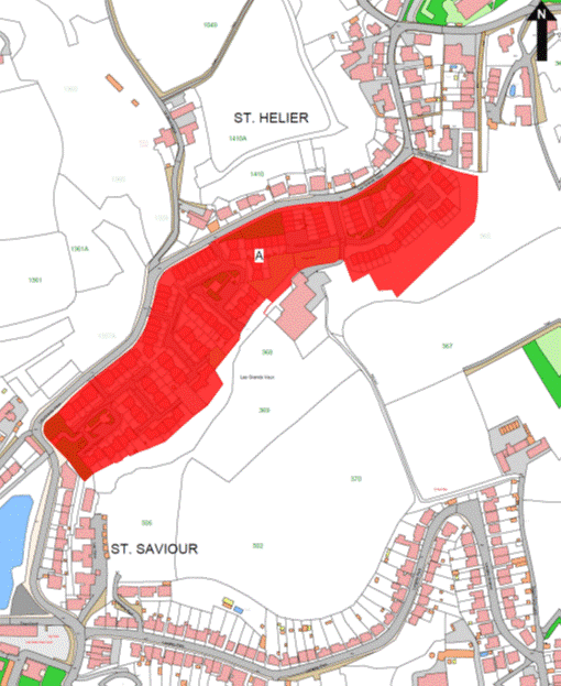
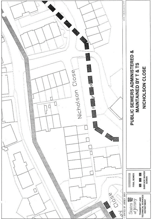
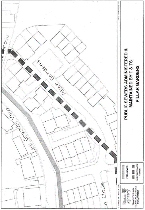
Part 141
10 Lempriere Street
(1) The
Property known as No. 10 Lempriere Street (“the Property”), as shown on
the Plan in this Part entitled “10 Lempriere Street”, to which the public has
right by contract of purchase dated 21st February 1975 (PR 634/518)
(“Contract of Purchase”).
(2) The
boundaries of the Property and all rights attaching thereto are as set out in
the Contract of Purchase and in the contract of sale by the public dated 1st
March 2002 (PR 1132/613).
NOTE:
The Property is situate in the
Parish of St. Helier in the Vingtaine du Bas du Mont-au-Prêtre and has the
UPRN 69127266.
10 Lempriere Street
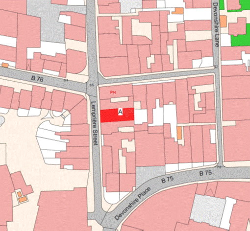
Part 142
Willow Court
(1) The
property known as Willow Court (“the Property”), as shown on the Plan in this
Part entitled “Willow Court”, to which the public has right (inter alia) by contract dated 21st December 1973
(PR 620/472) (“Contract of Purchase”).
(2) The
boundaries of the Property and all rights attaching thereto are as set out in –
(a) the Contract of Purchase;
(b) the Lease and Cession of Wayleave
Rights by the public to The Jersey Electricity Company Limited dated 3rd
November 1989 (PR 873/697);
(c) the contract of
arrangement dated 9th July 2004 (PR 1171/927); and
(d) sub-paragraph (3).
(3) The
boundaries towards the properties called The Limes, the Day Care Centre and
Willow House retained by the public are as follows –
(a) the boundary line
separating Willow House retained by the public from the Property is taken from
the north east corner of the brick pillar attached to the south east corner of
the southern wall of the Property in a northerly direction until reaching the
south west corner of the wall of the east of the Property towards Runnymede
Court;
(b) the boundary line
separating the Day Care Centre retained by the public from the Property is
taken from the south-east corner of a row of concrete slabs in a westerly
direction following the southern face of the row of concrete slabs and the
southern face of the southern end of the low concrete wall to the west of the
garden forming part of the Day Care Centre (which low concrete wall shall
belong to the public, without offset,) until reaching the south-west corner of
the low concrete wall, this boundary line being extended from the south-east
corner of the row of concrete slabs on the same alignment until reaching the
eastern boundary of the Property;
(c) a boundary line taken
from the north-west corner of the low concrete wall mentioned in sub-paragraph (b)
belonging to the public in a northerly direction until reaching the
south-western corner (the most southerly) of the building forming part of the
Day Care Centre;
(d) a boundary line taken
from the south-western corner (the most southerly) of the Day Care Centre in a
westerly direction following the southern face of the concrete kerb to the
south of the garden forming part of the Day Care Centre until reaching the
south-eastern corner of the brick wall also to the south of the garden forming
part of the Day Care Centre;
(e) the brick wall to the
south, south-west, west, north-west on 2 sections and north of the garden
forming part of the Day Care Centre which shall continue to belong, without
offset, to the public;
(f) a boundary line taken
from the north-western corner (the most northerly) of the brick wall to the
north-west of the garden forming part of the Day Care Centre in a
north-westerly then northerly then easterly direction following the outside
face of the concrete kerb towards the footpath forming part of Willow Court
belonging to the company and extended in an easterly direction from the
north-eastern corner of the northerly section of the concrete kerb on the same
alignment until reaching the western wall of the Day Care Centre;
(g) the western wall (on a
small section) and the northern wall of the Day Care Centre towards the
footpath belonging to the company shall continue to belong, without offset, to
the public;
(h) a boundary line taken
from the western corner of a decorative concrete kerb to the north-west of a
small landscaped area forming part of the Day Care Centre following the
north-western face of the decorative concrete kerb in a north-easterly
direction until intersecting with another boundary line taken from the
north-western corner (the most northerly) of the building forming part of the
Day Care Centre in a north-westerly direction until reaching the southern
corner of a building forming part of The Limes retained by the public;
(i) the south-western façade
of the building forming part of The Limes towards the Property shall continue
to belong, without offset, to the public;
(j) the brick wall to the
south-east of the garden forming part of The Limes and attached to the south-western
façade of the building forming part of The Limes towards the tiled passageway
forming part of the Property shall continue to belong, without offset, to the
public;
(k) a boundary line taken
from the southern corner of the wall of the south-east of The Limes mentioned
in sub-paragraph (j) in a southerly direction until reaching the northern
corner of the tiled kerb forming the outside edge of the tiled passageway
forming part of the Property;
(l) the tiled kerb forming
the outside edge to the north-west, north on 2 sections and west of the tiled
passageway forming part of the Property towards the garden forming part of The
Limes shall be transferred, without offset, to the company;
(m) the eastern, northern and
western walls of the building (the most northerly) forming part of the Property
shall be transferred, without offset, to the company;
(n) the tiled kerb forming
the outside edge of the tiled passageway to the north (inter alia)
of flats numbered 16 and 17 Willow Court forming part of the Property
shall be transferred, without offset, to the company;
(o) the eastern, northern and
western walls of the building (the second most northerly) forming part of
Willow Court shall be transferred, without offset, to the company;
(p) the tiled kerb to the
north, north-east on 2 sections and east-north-east of the tiled passageway to
the north and north-east of (inter alia) numbers 13 and 14 Willow
Court forming part of the Property shall be transferred, without offset, to the
company;
(q) the south-western façade
of the building (the most south-westerly) forming part of The Limes shall
continue to belong, without offset, to the public.
(4) The
property is transferred subject to the following rights –
(a) that the public shall
have, in perpetuity, an exclusive right to use 8 of the parking spaces forming
part of the access roadway lying to the south of Willow Court flats transferred
to the company, such parking spaces being marked as being for the use of the
public;
(b) that the public shall
have, in perpetuity, an exclusive right to use the conservatory situate on the
first floor and forming the northern corner of the north-western end of the
block of flats forming part of Willow Court belonging to the company, provided
that the public shall be responsible for the repair, rebuilding and maintenance
of the conservatory entirely at its own expense.
NOTE:
The location from time to time of
the 8 parking spaces shall be agreed between the parties.The Property is
situate in the Parish of St. Helier in the Vingtaine de Haut de la Ville
and has the UPRN 69386511.
Willow Court
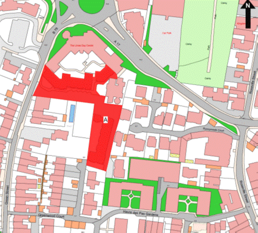
Part 143
Le Marais, La Sellière
Court, Les Hinguettes and Les Petites Hinguettes
(1) The
properties known as Le Marais, La Sellière Court, Les Hinguettes
and Les Petites Hinguettes (“the Properties”), as shown on the Plan in
this Part entitled “Le Marais, La Sellière Court, Les Hinguettes
and Les Petites Hinguettes”, to which the public has right by the
Contracts of Purchase dated –
(a) 16th January 1960.
(PR 473B/114); and
(b) 17th January 1969.
(PR 553/168),
“Contracts of Purchase”.
(2) The
boundaries of the Properties and all rights attaching thereto are set out in –
(a) the Contracts of Purchase;
(b) the following transactions –
(i) the Contract of purchase by The Jersey Electricity Company
Limited dated 18th November 1961 (PR 477C/48),
(ii) the Contract of sale by
the public dated 25th June 1976 (PR 655/114),
(iii) the Deed of Arrangement
dated 19th November 1982. (PR 752/341),
(iv) the Contract of sale
dated 29th April 1983. (PR 761/170), in so far as it relates to the
public parties to that contract,
(v) The Déclaration de Co Propriété of
Le Petit Marais Residential Association registered by Act of the Royal
Court dated 8th June 1993 (PR 942/336),
(vi) the Deed of Arrangement
dated 19th December 2003 (PR 1164/267),
(vii) the Contract of sale by
the public dated 11th August 2006 (PR 1206/156), and
(viii) the Deed of Arrangement
dated 23rd March 2007 (PR 1216/107);
(ix) Lease and Cession of
Wayleave Rights to The Jersey Electricity Company Limited dated 19th
May 2006 (PR 1200/722);
(c) the following contracts
of sale by the public –
(i) to The Jersey Electricity Company Limited
dated 19th May 2006 (PR 1200/732),
(ii) sale of No. 20
La Selliere dated 2nd June 2006 (PR 1201/344),
(iii) sale of No. 21
La Selliere dated 2nd June 2006 (PR 1201/357),
(iv) sale of No. 14
La Selliere dated 2nd June 2006 (PR 1201/505),
(v) sale of No. 3 La Selliere dated
9th June 2006 (PR 1201/599),
(vi) sale of No. 6
La Selliere dated 9th June 2006 (PR 1201/613),
(vii) sale of No. 8
La Selliere dated 9th June 2006 (PR 1201/645),
(viii) sale of No. 2
La Selliere dated 9th June 2006 (PR 1201/704),
(ix) sale of No. 10
La Selliere dated 9th June 2006 (PR 1201/716),
(x) sale of No. 22 La Selliere dated
9th June 2006 (PR 1201/785),
(xi) sale of No. 18
La Selliere dated 9th June 2006 (PR 1201/797),
(xii) sale of No. 19
La Selliere dated 9th June 2006 (PR 1201/815),
(xiii) sale of No. 1
La Selliere dated 9th June 2006 (PR 1201/897),
(xiv) sale of No. 5
La Selliere dated 9th June 2006 (PR 1201/911),
(xv) sale of No. 12
La Selliere dated 9th June 2006 (PR 1201/925),
(xvi) sale of No. 16
La Selliere dated 9th June 2006 (PR 1201/949),
(xvii) sale of No. 17
La Selliere dated 9th June 2006 (PR 1202/61),
(xviii) sale
of No. 11 La Selliere dated 9th June 2006 (PR 1202/74),
(xix) sale of No. 15
La Selliere dated 16th June 2006 (PR 1202/121),
(xx) sale of No. 9
La Selliere dated 16th June 2006 (PR 1202/227),
(xxi) sale of No. 13
La Selliere dated 16th June 2006 (PR 1202/356),
(xxii) sale of No. 7
La Selliere dated 16th June 2006 (PR 1202/493),
(xxiii) sale
of No. 23 La Selliere dated 16th June 2006
(PR 1202/508),
(xxiv) sale
of No. 4 La Selliere dated 30th July 2006 (PR 1203/338);
and
(d) sub-paragraph (3).
(3) The
boundary line separating the pumping station area retained by the public from
the Properties is a line joining the coordinate boundary points marked BP01 to
BP20 on the boundary location plan bearing the reference M628/01 in this Part
and described in the Table in this Part.
The walls of the building
housing the pumping station near the northern corner (the most easterly) of the
Properties and which is retained by the public shall continue to belong,
without offset, to the public.
(4) The
Properties are transferred on condition that no building or other construction
may ever be built on the area of land shaded in red and marked B on the Plan in
this Part entitled Le Marais Flood Impounding Area in perpetuity.
NOTE:
The
public administers and maintains a public foul sewer to the north-west of Block
F (Nos. 105 to 160) Le Marais that drains this block and Block E
(Nos. 49 to 104) Le Marais and extends to the west under the front
gardens and parking areas of Nos. 20 to 40 Le Petit Marais. Blocks G
and H (Nos. 161 to 272) Le Marais drain to a public foul trunk sewer
located to the south-west under the access road leading to Le Benefice and
that sewer extends to the north-west and lies under the parking areas for
Nos. 15 to 19 La Selliere.
The public also maintains and
administers a public surface water sewer that lies directly to the north of
Block E (Nos. 49 to 104) Le Marais that drains in a south westerly
direction and then lies under the eastern edge of the central triangular area
of Le Petit Marais.
The public administers and maintains
the public foul trunk sewer that lies under La Selliere Court road and
drains in a northerly direction to the public’s pumping station on La Rue
de Maupertuis to the north. This public trunk sewer cuts across the north-east
corner of La Selliere Court.
The public also administers and
maintains a public surface water trunk sewer that lies under the front gardens
and parking areas of Nos. 1 to 17 Le Petits Marais that extends
and crosses the north-east corner of Le Petit Marais. A branch sewer also
extends from this across the grass area to the north of La Selliere Court
that drains road water from La Rue de Maupertuis.
The Public does not maintain or
administer any branch connections from these sewers to the buildings or any
road drainage system in the roads and parking areas forming parts of the
Properties. The public does not maintain or administer any land drains in the
area of the Properties.
The current routes of the public
sewers described above are as shown on the plans in this Part entitled “Public
Sewers administered and maintained by T&TS Le Marais”, “Public Sewers
administered and maintained by T&TS La Selliere Court”, “Public Sewers
administered and maintained by T&TS Les Hinguettes”, “Public Sewers
administered and maintained by T&TS Les Petites Hinguettes”.
The properties are situate in the
Parish of St. Clement in the Vingtaine de Samarès and have the
UPRN 69386499, 69386663, 69407206 and 69386654.
Le Marais, La Sellière Court, Les Hinguettes and Les Petites
Hinguettes
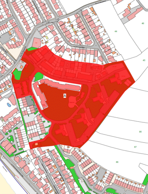
Le Marais Flood Impounding Area
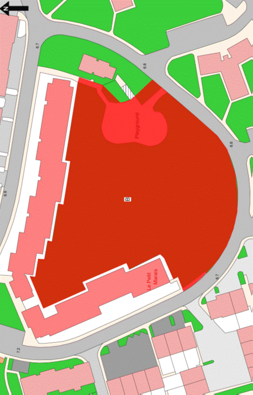
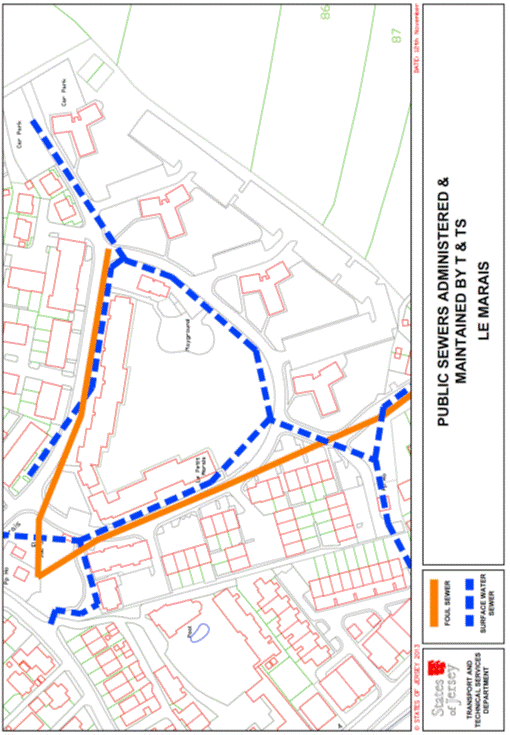
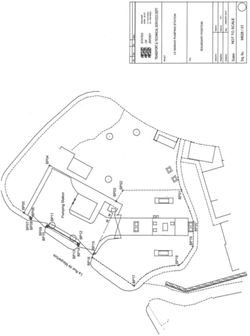
Table
|
Le Marais Pumping
Station, St. Clement
|
|
Co-ordinate and
Descriptive Definition of the Boundary Points.
The following coordinate listing and description apply to boundary
location plan M628/01. The boundary points have coordinates currently used in
the Jersey Map Grid System 2004.
The following coordinates represent the boundary points.
|
|
Point No.
|
Easting
|
Northing
|
Description
|
|
BP01
|
43931.37E
|
63673.95N
|
Point situated on outer edge of kerb (Northern Face), and 9.23 metres
North Eastwards from North West corner, and 7.93 metres North West from
North East corner of No. 3 Le Selliere Court.
|
|
BP02
|
43931.21E
|
63691.11N
|
Point situated on grass area 17.16 metres Northwards from
BP01 and 4.19 metres Eastwards from Southernmost corner of pumping Station
fence.
|
|
BP03
|
43928.05E
|
63693.07N
|
Point situated on pumping station fence, 3.72 metres North West
from BP02 and 2.15 metres North Eastwards from Southernmost corner of
pumping station fence.
|
|
BP04
|
43938.45E
|
63712.47N
|
Point on North Eastern corner of pumping station fence and 22.01 metres
North Eastwards (along fence line) from BP03.
|
|
BP05
|
43924.69E
|
63719.91N
|
Point situated on Northernmost corner of pumping station Fence and
15.65 metres North West from BP04 (along fence line).
|
|
BP06
|
43923.45E
|
63717.99N
|
Point situated where Western edge of pumping station fence meets
brick pillar forming the North side of the North Entrance to the pumping
station and 2.89 metres South West from BP05.
|
|
BP07
|
43923.14E
|
63718.14N
|
Point situated on the North West corner of brick pillar forming the
North side of the Northern entrance to the pumping station and 0.34 metres
North West from BP06.
|
|
BP08
|
43922.95E
|
63717.74N
|
Point situated on the South West corner of brick pillar forming the
North side of the Northern entrance to the pumping station and 0.44 metres
South West from BP07.
|
|
BP09
|
43920.72E
|
63713.43N
|
Point situated on the North West corner of brick pillar forming the
South side of the Northern entrance to the pumping station and 4.86 metres
South West from BP08.
|
|
BP10
|
43920.52E
|
63713.04N
|
Point situated on the South West corner of brick pillar forming the
South side of the Northern entrance to the pumping station and 0.44 metres
South West from BP09.
|
|
BP11
|
43920.91E
|
63712.84N
|
Point situated on the South East corner of brick pillar forming the
South side of the Northern entrance to the pumping station and 0.44 metres
South East from BP10.
|
|
BP12
|
43915.83E
|
63704.10N
|
Point situated on the North East corner of brick pillar forming the
North side of the Southern entrance to the pumping station and 10.10 metres
South West from BP11.
|
|
BP13
|
43915.43E
|
63704.30N
|
Point situated on the North West corner of brick pillar forming the
North side of the Southern entrance to the pumping station and 0.44 metres
North West from BP12.
|
|
BP14
|
43915.24E
|
63703.91N
|
Point situated on the South West corner of brick pillar forming the
North side of the Southern entrance to the pumping station and 0.44 metres
South West from BP13.
|
|
BP15
|
43912.86E
|
63699.57N
|
Point situated on the North West corner of brick pillar forming the
South side of the Southern entrance to the pumping station and 4.95 metres
South West from BP14.
|
|
BP16
|
43911.82E
|
63699.98N
|
Point situated on the face of kerb and 1.12 metres North West from
BP15.
|
|
BP17
|
43903.56E
|
63687.76N
|
Point situated on outer face of kerbing forming the back Edge of
footpath and 14.75 metres South West from BP16.
|
|
BP18
|
43909.53E
|
63674.77N
|
Point situated on outer face of kerbing forming the Eastern Edge of
the footpath and 14.30 metres South-South-West from BP19.
|
|
BP19
|
43915.02E
|
63670.57N
|
Point situated on outer face of kerbing forming the Northern Edge of
the footpath and 6.91 metres South East from BP18.
|
|
BP20
|
43922.05E
|
63670.40N
|
Point situated on outer face of kerb/South Eastern corner of concrete
base and 7.03 metres Eastwards from BP19.
|
Part 144
Robin Hood Flats
(1) The
Property known as Robin Hood Flats (“the Property”), as shown on the Plan in
this Part entitled “Robin Hood Flats”, to which the public has right by
contract of purchase dated 12th February 1965 (PR 498/96) (“Contract
of Purchase”).
(2) The
boundaries of the Property and all rights attaching thereto are as set out in
the Contract of Purchase and in sub-paragraph (3).
(3) The
eastern wall of the block of flats forming part of the Property and the granite
wall to the east of the Property towards the car park retained by the public
shall be transferred, without offset, to the company.
NOTE:
The Property is situate in the Parish
of St. Helier in the Vingtaine du Bas du Mont au Prêtre and has the
UPRN 69002521.
Robin Hood Flats
Part 145
Clydesdale and Belford
Place
(1) The
properties known as Clydesdale and Belford Place (“the Properties”), as shown
on the Plan in this Part entitled “Clydesdale and Belford Place”, to which the
public has right by the contracts of purchase dated –
(a) 12th July 1991
(PR 902/561); and
(b) 3rd June 1983
(PR 762/619),
(“Contracts of Purchase”).
(2) The
boundaries of the properties and all rights attaching thereto are as set out in
the Contracts of Purchase and in sub-paragraph (3).
(3) The
walls to the South of the properties towards Baudrette Brook retained by the
public shall be transferred, without offset, to the company.
NOTE:
The public administers and
maintains the structure and free flow of the culvert Baudrette Brook to the
south-east of the properties that lies in a north-east to south-west direction
to the rear of Nos. 1 to 6 Georgetown Park Estate.
The public does not maintain or
administer any branch pipe connections from this culvert to the adjacent
properties or any area above the culvert.
The current routes of the public
sewers described above are as shown on the plan in this Part entitled “Public
Sewers administered and maintained by T&TS Clydesdale and Belford Place”.
The properties are situate in the
Parish of St. Saviour in the Vingtaine de la Petite Longueville and have
the UPRN 69002101 and 69386478.
Clydesdale and Belford Place
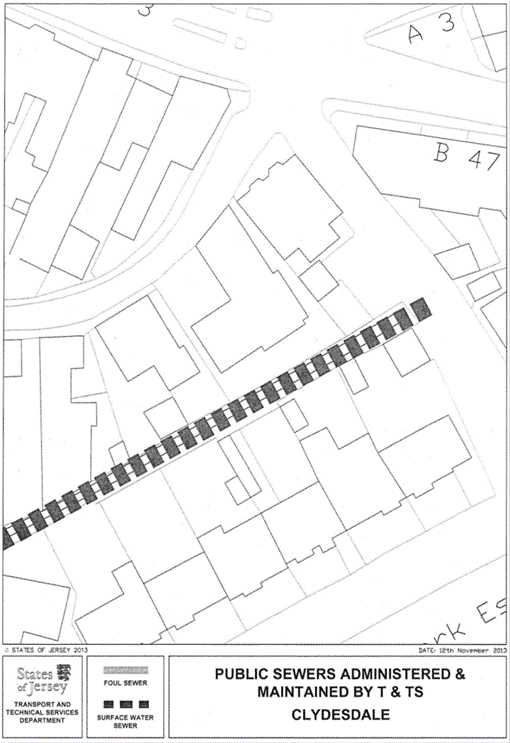
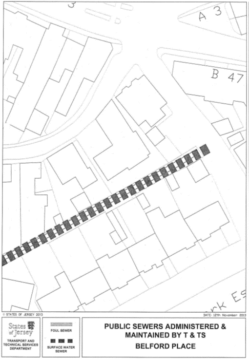
Part 146
79 Rouge Bouillon
(1) The
property known as 79 Rouge Bouillon (“the Property”), as shown on the Plan in
this Part entitled “79 Rouge Bouillon”, to which the public has right, first corpus fundi, by contract of purchase dated 27th
April 1984 (PR 778/352) (“Contract of Purchase”).
(2) The
boundaries of the Property and all rights attaching thereto are as set out in
the Contract of Purchase.
NOTE:
The Property is situate in the
Parish of St. Helier, Vingtaine du Rouge Bouillon and has the
UPRN 69003300.
79 Rouge Bouillon
Part 147
Brighton Close
(1) The
property now known as Brighton Close forming one corpus
fundi (“the Property”), as shown on the Plan in this Part entitled “Brighton
Close”, to which the public has right by the contracts of purchase dated –
(a) 25th April 1986 (PR 811/216);
(b) 15th November 1985
(PR 803/607);
(c) 6th July 1984
(PR 781/406); and
(d) 18th January 1985
(PR 789/245),
(“Contracts of Purchase”).
(2) The
boundaries of the Property and all rights attaching thereto are as set out in –
(a) the Contracts of Purchase;
(b) the following contracts –
(i) sale of land by the public to The Jersey
Electricity Company Limited dated 11th September 1987 (PR 836/242),
and
(ii) Cession of Wayleave
Rights by the public to The Jersey Electricity Company Limited dated 14th
July 1989 (PR 868/316); and
(c) sub-paragraph (3).
(3) The
wall of the south-east of the garage and of the building to the rear of the
garage forming parts of the fire station and police headquarters retained by
the public towards the Property shall continue to belong, without offset, to
the public.
NOTE:
The Property is situate in the
Parish of St. Helier, Vingtaine du Rouge Bouillon and has the
UPRN 69383721.
Brighton Close
Part 148
King George V Cottage Homes
(1) The
Property known as King George V Cottage Homes (“the Property”), as shown on the
Plan in this Part entitled “King George V Cottage Homes”, to which the public
has right by the Contracts of Purchase from dated –
(a) 30th March 1889
(PR 300/173);
(b) 2nd November 1901
(PR 334/195);
(c) 2nd November 1901
(PR 334/197);
(d) 8th November 1913
(PR 362/273);
(e) 7th December 1979
(PR 710/108); and
(f) 8th October 1982
(PR 750/306),
(“Contracts of Purchase”).
(2) The
boundaries of the Property and all rights attaching thereto are as set out in
the Contracts of Purchase and in sub-paragraph (3).
(3) The
fence to the south-east, north-east and north-west of the Property towards the
land retained by the public shall be transferred, without offset, to the
company.
NOTE:
The Property is situate in the
Parish of St. Helier in the Vingtaine du Mont à l’Abbé and has the
UPRN 69141337.
King George V Cottage Homes
Part 149
Gibraltar and Rock Cottage,
St. Martin
(1) The
properties known as Gibraltar and Rock Cottage (“the Properties”), as shown on
the Plan in this Part entitled “Gibraltar and Rock Cottage, St. Martin”,
to which the public has right by contract of Gift, Cession and Transfer dated
12th April 1878 from Sa Majesté (PR 267/266) (“Contract of
Acquisition”).
(2) The
boundaries of the properties and all rights attaching thereto are as set out in
the Contract of Acquisition and in sub-paragraphs (3) and (4).
(3) The
boundary lines separating the properties from the land retained by the public
and the main road is a line joining the coordinate boundary points numbered
BP01, BP02, BP03 and BP04 on the boundary location plan bearing the reference
M940/01 in this Part and described in the Table in this Part.
(4) The
hedges to the south-west on 2 sections, to the south and to the north-west of
the properties towards the land retained by the public shall be transferred,
without offset, to the company.
NOTE:
The properties are situate in the
Parish of St. Martin in the Vingtaine du Fief de la Reine and have the
UPRN 69124666 and 69124663.
Gibraltar and Rock Cottage, St. Martin
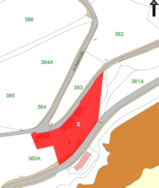
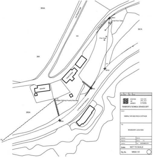
Table
|
Properties known as Gibraltar
and Rock Cottage, La Mont des Ormes, St. Martin.
|
|
Co-ordinate and
Descriptive Definition of the Boundary Points.
The following coordinate listing and description apply to boundary
plan number M940/01. The boundary points have coordinates currently used in
the Jersey Map Grid System 2004.
The following coordinates represent the boundary points.
|
|
Point No.
|
Easting
|
Northing
|
Description
|
|
BP01
|
47789.85E
|
69442.17N
|
Boundary Point on
Southern edge of Le Mont des Ormes.
|
|
BP02
|
47786.04E
|
69395.30N
|
Boundary Point on
Northern Edge of La Route de St. Catherine on a line projected from
BP01 through small Palm type tree and Telegraph pole and 33.34 metres South
Westwards from road gully.
|
|
BP03
|
47773.20E
|
69377.29N
|
Boundary Point on
Northern Edge of road against face of rock below hedge defining Eastern
boundary of Rock Cottage and 22.12 metres South West from BP02.
|
|
BP04
|
47743.96E
|
69347.31N
|
Boundary Point on
Northern edge of La Route de St. Catherine, below hedge defining
Western boundary of Rock Cottage and 41.88 metres South West from BP03.
|
Part 150
Le Coin Flats
(1) The
Property known as Le Coin Flats (“the Property”), as shown on the Plan in
this Part entitled “Le Coin Flats”, to which the public has right by the
following Acts of the Royal Court under the Compulsory Purchase of Land
(Procedure) (Jersey) Law 1948 dated 11th February 1952 –
(a)(PR 455C/231);
(b)(PR 455C/232);
(c)(PR 455C/233);
(d)(PR 455C/234);
(e)(PR 455C/236);
(f)(PR 455C/237);
(g)(PR 455C/238); and
(h)(PR 455C/239),
(“Acts of the Royal Court”).
(2) The
boundaries of the Property and all rights attaching thereto are as set out in
the Acts of the Royal Court and in –
(a) the Deed of Arrangement
dated 12th July 2013 (PR 1315/44); and
(b) the Contract of sale by
the public dated 17th January 2014 (PR 1324/832).
NOTE:
The Property is situate in the
Parish of St. Helier in the Vingtaine du Haut de la Ville and has the
UPRN 69002001.
Le Coin Flats
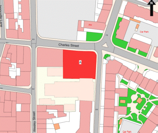
Part 151
23 Le Douet de Ste.
Croix
(1) The
property known as 23 Le Douet de Ste. Croix (“the Property”), as shown on
the Plan in this Part entitled “23 Le Douet de Ste. Croix”, to which the
public has right (inter alia) by the
contracts of purchase dated –
(a) 5th April 1991
(PR 898/7); and
(b) 5th April 1991
(PR 898/15),
(“Contracts of Purchase”).
(2) The
boundaries of the Property and all rights attaching thereto are as set out in –
(a) the Contracts of Purchase;
(b) the following Contracts
and Deeds of Arrangement –
(i) the Deed of Arrangement dated 5th
April 1991 (PR 898/19),
(ii) the contract of Sale and
Cession of Wayleave Rights by the public to The Jersey Electricity Company
Limited dated 30th June 1995 (PR 991/9),
(iii) the Deed of Arrangement
dated 6th October 1995 (PR 997/411),
(iv) the contract of sale of
22 Le Douet de Ste Croix by the public dated 21st July 1995
(PR 992/209), and
(v) the contract of sale of 24 Le Douet de
Ste Croix by the public dated 25th August 1995 (PR 994/524); and
(c) sub-paragraph (3).
(3) The
concrete border at ground level to the west of the Property towards the roadway
and pavement retained by the public shall be transferred, without offset, to
the public.
NOTE:
The Property is situate in the
Parish of St. Helier in the Vingtaine du Mont à l’Abbé and having the
UPRN 69115096.
23 Le Douet de Ste. Croix
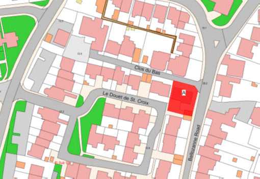
Part 152
Sandybrook Court and Car
Park
(1) The
property forming 2 corpus fundi known as
Sandybrook Court (the first corpus fundi) and
the car park (the second corpus fundi)
(together “the Property”), as shown on the Plan in this Part entitled “Sandybrook
Court and Car Park”, to which the public has right (inter
alia) by the Contracts of Purchase dated –
(a) 27th September 1947
(PR 446A/246); and
(b) 29th April 1950
(PR 452B/120),
(“Contracts of Purchase”).
(2) The
boundaries of the Property and all rights attaching thereto are as set out in –
(a) the Contracts of Purchase;
(b) the following transactions –
(i) the Deed of Arrangement dated 11th August 1967
(PR 533/255),
(ii) the contract of Gift,
Cession and Transfer dated 25th November 1977 (PR 678/476), in so far
as it relates to the public parties to that contract,
(iii) the contract of sale
dated 30th March 1979 (PR 701/591),
(iv) the contract of sale
dated 1st October 1980 (PR 750/218), in so far as it relates to the
public parties to that contract, and
(v) the Lease and Cession of Wayleave Rights to
The Jersey Electricity Company Limited dated 9th July 1999
(PR 1080/326); and
(c) sub-paragraphs (3)
to (12).
(3) The
granite wall to the west or thereabouts in a curve, to the north-east and to
the east or thereabouts in a curve of the first corpus
fundi shall be transferred, without offset, to the company.
(4) A
boundary line taken from the southern corner of the south-western end of the
granite wall mentioned above and forming part of the first corpus fundi in a south-easterly direction until
reaching the north-eastern corner of the wall forming part of the property
retained by the public where it joins on to the north-western side of the
building forming part of the first corpus fundi.
(5) A
boundary line taken from the north-eastern corner of the wall forming part of
the property retained by the public where it joins on to the north-western side
of the building forming part of the first corpus
fundi in a south-westerly direction following the outside face of the
wall of the building forming part of the first corpus
fundi for a short distance until reaching the eastern corner of the row
of concrete paving slabs at ground level towards the grassed and landscaped
areas retained by the public then in a north-westerly direction following the
outside edge of the north-eastern end of the row of concrete paving slabs until
reaching the northern corner of the row of concrete paving slabs then in a
south-westerly direction still following the outside edge of the concrete
paving slabs until reaching the western corner the most westerly of the
concrete paving slabs.
(6) A
boundary line taken from the western corner the most westerly of the concrete
paving slabs in a south-easterly, south-westerly for a small section,
south-easterly for a small section, north-easterly for a small section and
south-easterly direction following the outside face of the concrete slabs at
ground level until reaching the southern corner the most easterly of the
concrete paving slabs forming part of the first corpus
fundi.
(7) A
boundary line taken from the southern corner the most easterly of the concrete
paving slabs forming part of the first corpus fundi
in a north-easterly then south easterly direction following the outside edge of
the row of paving slabs at ground level forming part of the first corpus fundi and continuing in a south easterly
direction on the same alignment until reaching the paved pathway leading to the
entrance to the building forming part of the first corpus
fundi.
(8) The
paved pathway mentioned above and the red tarmaced pathway leading from the
paved pathway to the access road with the concrete kerbing at ground level on
its north-western, western, south-eastern and eastern sides and the small paved
area lying to the south-east of the north eastern end of the red tarmaced
pathway shall belong, without offset, to the company and form part of the first
corpus fundi.
(9) A
boundary line taken from the northern corner of the row of concrete paving
slabs lying to the south-west of the small paved area mentioned above and to
the north-west of the building forming part of the first corpus fundi in a south-westerly direction
following the outside edge of the concrete paving slabs until reaching the
western corner of the concrete paving slabs.
(10) A
boundary line taken from the western corner of the concrete paving slabs lying
immediately to the west of the western corner the most southerly of the
building forming part of the first corpus fundi
in a south-easterly, south-westerly for a small section, south-easterly for a
small section, north-easterly for a small section and south-easterly, easterly
and north-easterly direction following the outside face of the concrete slabs
at ground level until reaching the wall lying to the south-west of the paved
access pathway mentioned below and forming part of the first corpus fundi.
(11) The
concrete kerb to the south-east of the pavement and paved access pathway
forming part of the first corpus fundi
towards the access road leading to Sandybrook Hospital retained by the public
and the wall and the concrete kerbing at ground level to the south-west of the
paved access pathway towards a landscaped area retained by the public shall
belong, without offset, to the company.
(12) The
boundaries of the second corpus fundi towards
the grassed and landscaped areas retained by the public shall be (i) the
concrete kerbing to the north-west on 2 sections, the north-east, the
south-east and the south-west of the tarmaced car park forming the second corpus fundi shall belong, without offset, to the
public and (ii) a boundary line across the entrance to the second corpus fundi running in a north easterly direction
following the inside faces of the concrete kerbing to the north-west on 2
sections of the second corpus fundi and lying
to the south-west and north-east respectively of the entrance to the second corpus fundi.
NOTE:
The Property is situate in the
Parish of St. Peter in the Vingtaine de St. Nicholas and has the
UPRN 69383844 and 69386662.
Sandybrook Court and Car Park
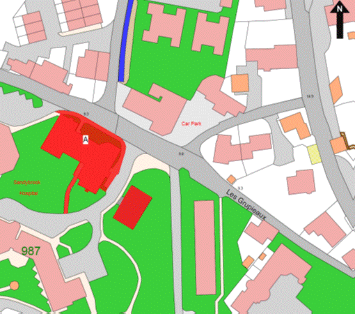
Part 153
The Cedars
(1) The
Property known as The Cedars (“the Property”), as shown on the Plan in this
Part entitled “The Cedars”, to which the public has right by the Contracts of
Purchase dated –
(a) 19th April 1968
(PR 544/134);
(b) 7th June 1968 (PR 546/140);
(c) 7th June 1968
(PR 546/144); and
(d) 17th September 1971
(PR 587/66),
(“Contracts of Purchase”).
(2) The
boundaries of the Property and all rights attaching thereto are as set out in
the Contracts of Purchase and in sub-paragraphs (3), (4) and (5).
(3) The
walls to the north-west and north-north-west of the Property towards the road
owned by the public known as La Rue de l’Est shall be transferred, without
offset, to the company.
(4) The
boundary to the north-east of the Property towards the Tunnel retained by the
public is a line joining the coordinate boundary points numbered BP03 and BP04
on the boundary survey plan bearing the reference M800/02 in this Part and
described in the Table in this Part.
(5) A
co ordinate and descriptive definition of the boundary points is also attached
to this Part.
NOTE:
The Property is situate in the
Parish of St. Helier in the Vingtaine du Haut de la Ville and has the
UPRN 69406075.
The Cedars
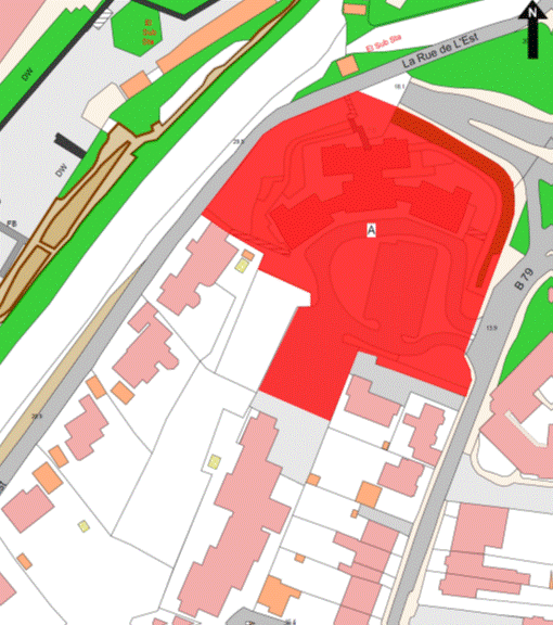
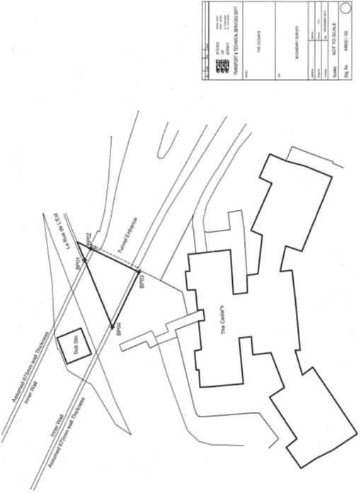
Table
|
Properties known as The
Cedars, Green Street, St. Helier.
|
|
Co-ordinate and
Descriptive Definition of the Boundary Points.
The following coordinate listing and description apply to boundary
location plan M800/02. The boundary points have coordinates currently used in
the Jersey Map Grid System 2004.
The following coordinates represent the boundary points.
|
|
Point No.
|
Easting
|
Northing
|
Description
|
|
BP01
|
42239.68E
|
65065.00N
|
Boundary Point on South face of
wall forming Southern edge of La Rue de L’Est.
|
|
BP02
|
42241.92E
|
65063.93N
|
Boundary Point on Western face of wall forming the Eastern entrance
/ exit for the Tunnel and 2.48 metres South Eastwards
from BP01.
|
|
BP03
|
42237.42E
|
65054.76N
|
Boundary Point on Western face of wall forming the Eastern entrance
/ exit for the Tunnel and 10.22 metres South-South Westwards
from BP02.
|
|
BP04
|
42226.99E
|
65059.80N
|
Boundary Point on South face of wall forming Southern edge of La Rue
de L’Est and 11.58 metres North Westwards from BP03
and 13.72 metres South Westwards from BP01.
|
Part 154
Fields 91 and 91a
St. Brelade
(1) The
property known as Fields 91 and 91a St. Brelade (“the Property”), as shown
on the Plan in this Part entitled “Fields 91 and 91a St. Brelade”, to
which the public has right by compulsory purchase by Acts of the Royal Court
dated 11th December 1992 (PR 931/251) and 29th July 1994
(PR 972/1) (“Acts of the Royal Court”).
(2) The
boundaries of the Property and all rights attaching thereto are as set out in
the Acts of the Royal Court and in –
(a) the Contract of sale by
the public dated 13th November 1998 (PR 1065/54);
(b) the Contract of sale by
the public dated 9th December 2002 (PR 1193/817); and
(c) the Contract of sale by
the public dated 2nd May 2008 (PR 1235/781).
(3) The
walls to the north, to the north-west and north-east of the Property towards a
grassed area retained by the public shall be transferred, without offset, to
the company.
NOTE:
The public administers and
maintains a public foul sewer through the Property that runs in a north to
south direction to the west and running parallel with La Route des
Quennevais. A branch public sewer extends from this main line to the west and
into Belle Vue.
The public does not maintain or
administer any road drainage system, surface water sewer or soakaway systems
within the Property.
The current routes of the public
sewers described above are as shown on the plan in this Part entitled “Public
Sewers administered and maintained by T&TS Fields 91 & 91A – Belle Vue,
St. Brelade”.
Fields 91 and 91a St. Brelade
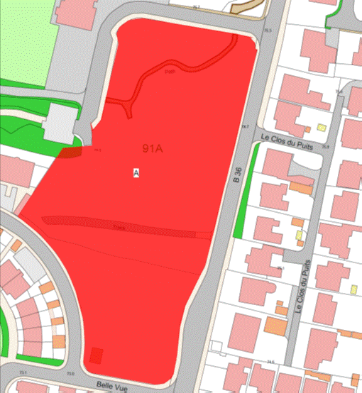
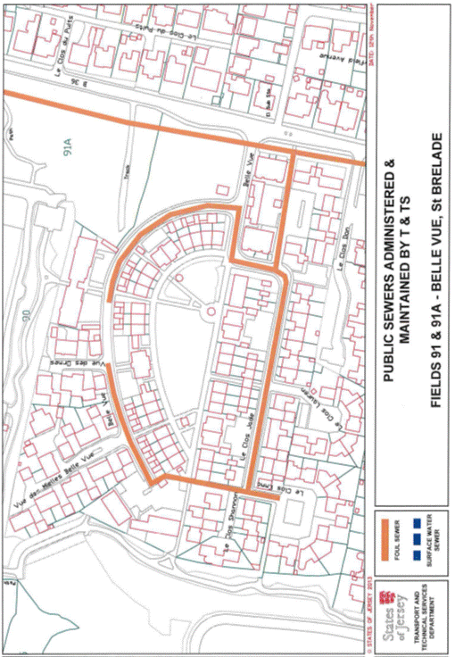
Part 155
Leslie Sinel Close
(1) The
property known as Leslie Sinel Close (“the Property”), as shown on the Plan in
this Part entitled “Leslie Sinel Close”, to which the public has right by
contract of purchase dated 16th March 1990 (PR 879/639)
(“Contract of Purchase”).
(2) The
boundaries of the Property and all rights attaching thereto are as set out in
the Contract of Purchase and in a contract of Lease and Cession of Wayleave Rights
by the public to The Jersey Electricity Company Limited dated 13th November 1992
(PR 929/475) and in sub-paragraph (3).
(3) The
wall to the south east or thereabouts of the Property towards a landscaped area
(formerly the site of 76 Val Plaisant) shall be transferred, without offset, to
the company.
NOTE:
The Property is situate in the
Parish of St. Helier in the Vingtaine du Rouge Bouillon and has the
UPRN 69384089.
Leslie Sinel Close
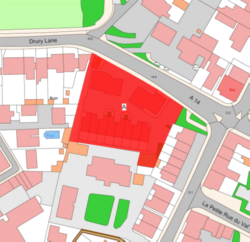
Part 156
La Cache Pallot,
La Place Labey and La Rue Hilgrove
(1) The
properties known as La Cache Pallot, La Place Labey and La Rue
Hilgrove (“the Properties”), as shown on the Plan in this Part entitled
“La Cache Pallot, La Place Labey and La Rue Hilgrove”, to which
the public has right by the contracts of purchase dated –
(a) 1st November 1974
(PR 630/579);
(b) 24th June 1977
(PR 671/452); and
(c) 27th November 1981
(PR 736/608),
(“Contracts of Purchase”);
and
(d) by
compulsory purchase from unknown owners by Act of the Royal Court dated 24th
April 1981 (PR 728/235) (“Act of the Royal Court”).
(2) The
boundaries of the Properties and all rights attaching thereto are as set out in
the Contracts of Purchase and the Act of the Royal Court and in a contract of Sale
and Cession of Wayleave Rights by the public to the Jersey Electricity Company
Limited dated 5th March 1982 (PR 740/186).
NOTE:
The Public administers and
maintains both foul and surface water sewers that extend from the public sewers
in Gorey Village Main Road heading to the east along La Rue Hilgrove
before further extending to the north to drain properties on La Sente
Bree.
The Department administers and
maintains both foul and surface water sewers in La Cache Pallot that
extend south from La Rue Hilgrove. The foul sewer enters the Properties as
far as No. 2 La Cache Pallot and the surface water sewer extends
further to the south-west as far as the parking area before turning west and
extending into the parking area to a point adjacent to No. 10
La Cache Pallot.
The Public administers and
maintains both foul and surface water sewers in La Place Labey that extend
south from La Rue Hilgrove and then head in a north-west direction under
the archway to a point near to the junction with Le Chemin des Maltieres.
Foul and surface water sewers extend from these sewers adjacent to No. 3
La Place Labey to as far as No. 9 La Place Labey. The foul sewer
then extends again from this point for a short distance to the south-east.
The Public does not maintain or
administer any branch connections from these sewers to the properties or any
road drainage system in La Rue Hilgrove, La Cache Pallot or
La Place Labey.
The current routes of the public
sewers described above are as shown on the plan in this Part entitled “Public
Sewers administered and maintained by T&TS La Rue Hilgrove, La Cache
Pallot & La Place Labey”.
The properties are situate in the
Parish of Grouville in the Vingtaine des Marais and have the
UPRNs 69108893, 69108894 and 69386655.
La Cache Pallot, La Place Labey and La Rue Hilgrove
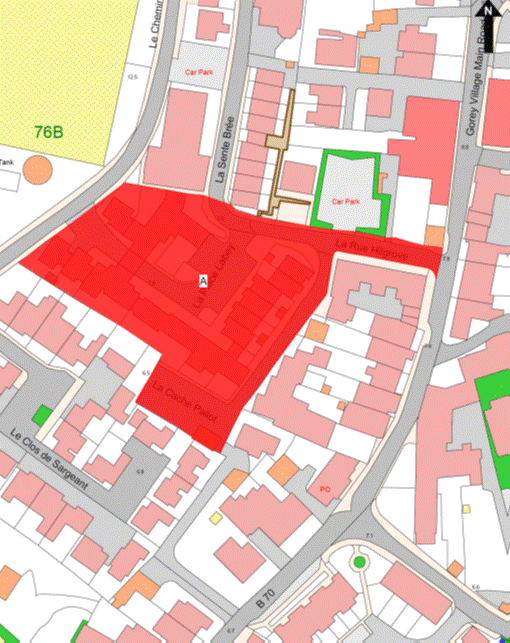
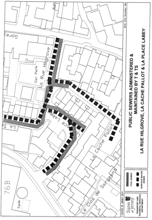
Part 157
Le Clos des Quennevais
(1) The
property known as Le Clos des Quennevais (“the Property”), as shown on the
Plan in this Part entitled “Le Clos des Quennevais”, to which the public
has right by contract of purchase dated 20th June 1925
(PR 395/252) (“Contract of Purchase”).
(2) The
boundaries of the Property and all rights attaching thereto are as set out in
the Contract of Purchase and in the following sub-paragraphs.
(3) The
wooden fence and wire fence to the north of the Property towards a bank and
footpath retained by the public shall be transferred, without offset, to the
company.
(4) The
granite wall to the south of the Property towards the public car park retained
by the public shall be party owned between the parties.
NOTE:
The Property is situate in the
Parish of St. Brelade in the Vingtaine des Quennevais and having the
UPRN 69386628.
Le Clos des Quennevais
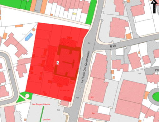
Part 158
163–170 Le Clos des
Sables
(1) The
property known as 163–170 Le Clos des Sables (“the Property”), as
shown on the Plan in this Part entitled “163–170 Le Clos des Sables”,
forming 2 corpus fundi to which the public
has right (inter alia) by contract of
purchase dated 13th February 1926 (PR 397/163) (“Contract of
Purchase”).
(2) The
boundaries of the first corpus fundi of the
Property and all rights attaching thereto are as set out in the Contract of
Purchase and in the Déclaration of Co-ownership establishing the 171–186 Le Clos
des Sables Association registered by Act of the Royal Court dated 19th
October 2012 (PR 1302/602).
(3) The
boundaries of the second corpus fundi of the
Property and all rights attaching thereto are as set out in the Contract of
Purchase and sub-paragraphs (4) to (10).
(4) The
dividing wall between the row of 8 garages forming part of the second corpus fundi and the most southerly garage which is
retained by the public shall be party owned between the parties.
(5) The
wall of the north-west with the door opened therein of the most southerly
garage of the block retained by the public shall belong, without offset, to the
public.
(6) The
concrete kerb to the north-west of the landscaped area to the south-east of the
most southerly garage of the block retained by the public shall belong, without
offset, to the public.
(7) The
wall to the south-west of the row of 8 garages forming part of the second corpus fundi towards Les Quennevais school car
park retained by the public shall be transferred, without offset, to the
company.
(8) The
wall to the north-west of the row of 8 garages forming part of the second corpus fundi towards the grassed area forming part
of the railway walk retained by the public shall be transferred, without
offset, to the company.
(9) The
concrete kerb to the south-east of the grassed area forming part of the railway
walk retained by the public towards the tarmaced area forming part of the
second corpus fundi shall belong, without
offset, to the public.
(10) A
boundary line separating the tarmaced area forming part of the second corpus fundi and the roadway leading to the railway
walk belonging to the public is an imaginary straight line taken from the
eastern corner of the concrete kerb to the south-east of the grassed area
forming part of the railway walk retained by the public in a north-easterly
direction until reaching the western corner of the wall to the south west of
117 Le Clos des Sables.
NOTE:
The public administers and
maintains a public foul sewer that crosses the land to the west of the block
containing Nos. 163 to 170 Clos des Sables in an approximate north to
south direction. The sewer enters the Property from the road to the north
adjacent to No. 117 Clos des Sables heading in a southerly direction until
at a point to the west of the block the sewer turns to the south-east and
enters the parish road at a point between this block and that of Nos. 179
to 186 Clos des Sables.
The public does not maintain or
administer any branch connections from this sewer to the flats or any road
drainage system in the parish roads or any drainage in the garage block area to
the north-west.
The current route of the public
sewer described above is as shown on the plan in this Part entitled “Public
Sewers administered and maintained by T&TS 163–170 Clos des Sables”.
163–170 Le Clos des Sables
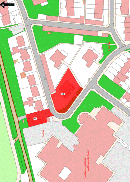
Part 159
Don Farm
(1) The
Property known as Don Farm (“the Property”), as shown on the Plan in this Part
entitled “Don Farm”, to which the public has right (inter
alia) by the Contracts of Purchase dated –
(a) 9th August 1968
(PR 548/254);
(b) 9th August 1968
(PR 548/256); and
(c) 13th September 1974
(PR 629/200),
(“Contracts of Purchase”).
(2) The
boundaries of the Property and all rights attaching thereto are as set out in
the Contracts of Purchase and in the following contracts of sale –
(a) 66 Don Farm by the public
dated 30th April 1976 (PR 652/350);
(b) 67 Don Farm by the public
dated 20th February 1976 (PR 650/17);
(c) 68 Don Farm by the public
dated 5th September 1975 (PR 643/80); and
(d) 73 Don Farm by the public
dated 29th August 1975 (PR 642/447); and
(e) in sub-paragraph (3).
(3) The
ends of walls to the west of the Property towards Les Quennevais playing
fields shall be transferred, without offset, to the company and a line of
demarcation shall be taken from the south-west corner of the end of the wall
the most northerly in a southerly direction until reaching the north-west corner
of the end of wall the most southerly.
NOTE:
The public administers and
maintains public foul and surface water sewers that extend into the Don Farm
access road from the south between the Communicare Centre and
St. Bernadette’s Church. From this point the foul sewer extends to the
east to a point adjacent to the north-west corner of the Communicare Centre and
the surface water sewer to a point adjacent to the eastern boundary of
No. 3 Don Farm. Both public foul and surface water sewers also extend to
the west following the line of the estate road, the foul to a point adjacent to
the south-east corner of No. 105 and the surface water as far west as the
vehicle access leading to the cycle track to the north of the pool complex.
From these main sewers, foul and surface water sewers extend via 3 main
branches into the estate to the north.
Branch 1. Foul and surface
water sewers extend to the north under the access road between Nos. 2 and
80 Don Farm to a point to the east of No. 82 Don Farm where branch
connections head to the east to a point adjacent to the south-east corner of
No. 7 Don Farm before heading in a southerly direction to the northern
boundary of No. 2 Don Farm. The foul and surface water sewers head further
into Don Farm to the road junction to the west of No. 8 Don Farm where
they bifurcate into 2 further branches, one to the north and one to the west.
The northerly branches extend to a point adjacent to No. 16 Don Farm where
they turn to the east to a point opposite the boundary of Nos. 13 and 14
Don Farm. The westerly branches continue under the estate road to a point at
the boundary between Nos. 20 and 19 Don Farm where they head north
between the 2 dwellings to a point to the west of No. 22 Don Farm and then
west adjacent to No. 30 Don Farm.
Branch 2. From the main
estate road, branch foul and surface water sewers extend to the north between
Nos. 77 and 78 Don Farm to a point adjacent to the south-east corner of
No. 17 Don Farm where they then head in a westerly direction to the south
of No. 33 Don Farm. The sewers then bifurcate with one branch heading
south to a point to the west of No. 89 Don Farm and then west to the east
of No. 92 Don Farm and a branch extending to the north between
Nos. 33 and 34 Don Farm to a point to the west of No. 37 Don Farm and
then in a westerly direction to a point to the south of No. 43 Don Farm.
Branch 3. From the main estate
road, branch foul and surface water sewers extend to the north and west between
Nos. 71 and 90 Don Farm and follow the estate road. At a point to the east
of No. 63 Don Farm branch sewers extend to the south to a point to the
north of No. 68 and then head west to a point to the east of No. 65
Don Farm. The foul and surface water sewers continue under the estate road to
the junction to the west of No. 96 Don Farm where branch sewers extend to
the west adjacent to No. 57 and then to the south to between Nos. 59
and 61 Don Farm. The sewers extend further to the north from adjacent to
No. 96 Don Farm under the estate road to a point to the west of
No. 36 Don Farm where they then head in a westerly direction and to the
east of No. 48 head to the north to the south of the parking area for
No. 47 Don Farm.
The Public also maintains and
administers all branch foul and surface water connections from the sewers to
the property boundaries but does not maintain or administer any road drainage
systems within the estate.
The current routes of the public
sewers described above are as shown on the plan in this Part entitled “Public
Sewers administered and maintained by T&TS Don Farm, St. Brelade”.
The Property is situate in the
Parish of St. Brelade in the Vingtaine des Quennevais and having the
UPRN 69383605.
Don Farm
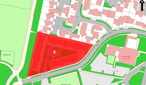
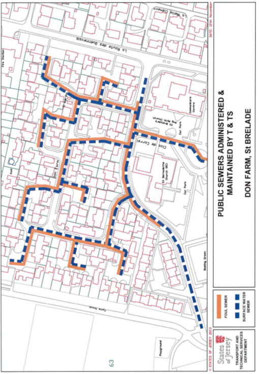
Part 160
Le Clos St. André,
St. Andrew’s Court and Les Jardins du Soleil
(1) The
properties known as Le Clos St. André, St. Andrew’s Court and Les Jardins
du Soleil (“the Properties”), as shown on the Plan in this Part entitled
“Le Clos St. André, St. Andrew’s Court and Les Jardins du
Soleil”, to which the public has right by the contracts of purchase (inter alia) dated –
(a) 1st March 1991
(PR 896/302);
(b) 10th June 1966
(PR 516/7); and
(c) 19th November 1982
(PR 752/329),
(“Contracts of Purchase”).
(2) The
boundaries of the properties and all rights attaching thereto are as set out in –
(a) the Contracts of Purchase;
and
(b) the following contracts –
(i) sale of road and pavements in Le Clos
St. André by the public dated 11th March 1988 (PR 845/164), and
(ii) lease of Shop A, Les Jardins
du Soleil by the public dated 15th January 1999 (PR 1068/422), and
(iii) Lease and Cession of
Wayleave Rights by the public to The Jersey Electricity Company Limited dated
14th July 2000 (PR 1101/797); and
(c) paragraph (3).
(3) The
boundaries towards the property retained by the public are as follows –
(a) the Southern boundary of
the Properties towards a Pavilion, bowling green and surrounding land belonging
to the public (“the Bowling Premises”) is constituted by the concrete block
wall which belongs, without offset, to the public;
(b) The Eastern, Northern and
(on a small section) Western boundaries of the Properties towards the Bowling
Premises are constituted by party owned hedges;
(c) the Eastern boundary of
the Properties towards a car park retained by the public (“the Car Park”) is
constituted by the Western face of the West wall of the Car Park and the
Western face of the sloping wall in extension of the said West wall together
with the West (or thereabouts) face of the pillar which all belong, without
offset, to the public;
(d) the remainder of the East
boundary of the Properties towards the Car Park and the public footpath which
leads to La Rue es Nouaux is constituted by an imaginary line taken from
the South-West corner of the tactile paving at the base of the Car Park steps
near the North-West corner of the Car Park and prolonged towards the North
following the East side of the purple paved kerbing at ground level (the most
Easterly) which kerbing shall be transferred, without offset, to the company,
until it reaches the centre of the party-owned hedge of the North towards the
Bowling Premises;
(e) the remainder of the
North boundary of the Properties towards the Car Park is constituted by an
imaginary line taken from the South-West corner of the area of tactile paving
at the base of the Car Park steps near the North-West corner of the Car Park
and prolonged towards the East following the South side of the area of tactile
paving described above and which belongs, without offset, to the public until
it reaches the boundary wall forming part of the Car Park.
NOTE:
The
public administers and maintains the following public sewers in the
Properties –
Le Clos
St. André
The public administers and
maintains both public foul and surface water sewers in Le Clos
St. André roads as well as along the southern boundary of Le Clos
St. André. A public foul sewer drains in a south-west direction from the
junction of Le Clos St. André and La Route es Nouaux crossing
under a clothes drying and parking area and then in a westerly direction to the
south of No. 22 Le Clos St. André and No. 8 Le Clos
St. André before draining south to the west of the Sun Bowls Club bowling
green. A large public surface water culvert that drains the Bellozanne Valley
catchment as well as taking the flow from the Sewage Treatment Works runs on a
similar line. Public foul and surface water branches extend to the north off
these sewers to the east of Nos. 17 to 22 Le Clos St. André and
then along the main road within the Property to the west as far as No. 66
Le Clos St. André. Small branches also extend eastward from these
branch sewers opposite No. 19 Le Clos St. André into the parking
area adjacent to the flats. Other branch sewers extend north from the junction
with St. Andrew’s Court and cross under the gardens of Nos. 8 to 13
Le Clos St. André before entering the main road within the Property.
Public foul and surface water branch sewers extend to the west and then
north-west from the garden of No. 12 Le Clos St. André before
entering St. Andrew’s Road.
The main public surface water
culvert extends further to the west from the junction with St. Andrew’s
Court, to the south of No. 7 Le Clos St. André and other private
properties before reaching La Mielle Villas on Le Mont Cochon.
The public also maintains and
administers the branch connection from these public sewers to the individual
property boundaries but does not maintain any road drainage system in the roads
within the Property.
St. Andrew’s Court
The
public administers and maintains a large public surface water culvert that
crosses through the Property under the access road in a north to south
direction from Le Clos St. André. Adjacent to No. 12
St. Andrew’s Court the culvert then turns west and then south-west between
Nos. 7 and 8 St. Andrew’s Court before exiting out into La Route
de St. Aubin between Les Jardins du Soleil and The Old
Bakehouse/Brooklyn House.
The public does not maintain or
administer any branch connections from this sewer to the buildings or any
surface water or road drainage system in the Property.
Les Jardins du Soleil
The
public administers and maintains a public foul sewer that enters the Property
at the north-east corner and lies along the northern boundary under the
pedestrian way. At a point adjacent to No. 8 St. Andrew’s Court the
sewer enters into that Property before heading south and exiting into
La Route de St. Aubin to the east of The Old Bakehouse/Brooklyn
House.
Two large pumped pressure mains
lie under the south-west garden of Les Jardins du Soleil that transfer the
islands sewage from the pumping station at First Tower up to Bellozanne Valley
for processing. These pipes enter the site from La Route es Nouaux at the
south east corner and approximately following the building line across the
gardens to the west before exiting out onto La Route de St. Aubin to
the east of The Old Bakehouse/Brooklyn House.
The routes of the public sewers
described above are as shown on the plans in this Part entitled “Public Sewers
administered and maintained by T&TS Les Jardins du Soleil”, “Public
Sewers administered and maintained by T&TS St. Andrew’s Court”, and “Public
Sewers administered and maintained by T&TS Clos St. André”.
The properties are situate in the
Parish of St. Helier in the Vingtaine du Mont à l’Abbé and have the
UPRNs 69388630, 69386666 and 69384245.
Le Clos St. André, St. Andrew’s Court and Les Jardins
du Soleil
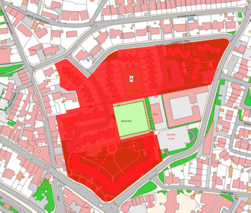
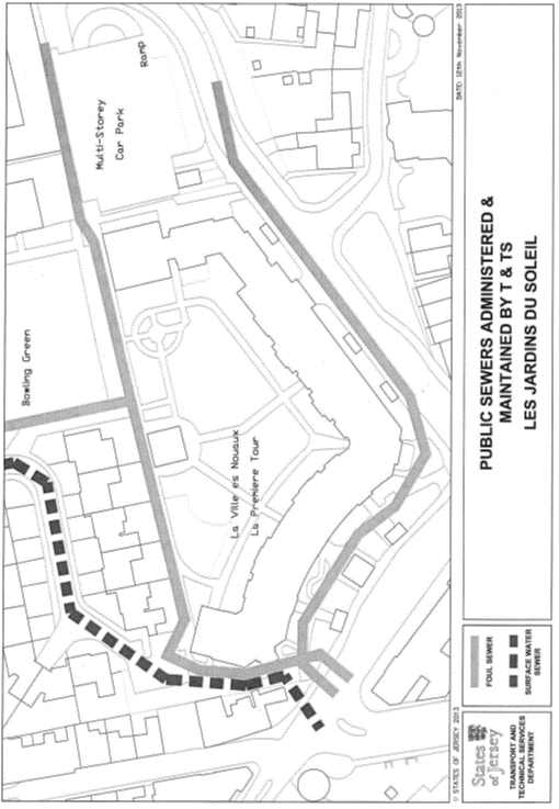
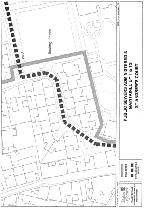
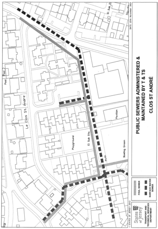
Part 161
Keepers Cottages Corbière
(1) The
property known as Keepers Cottages (“the Property”), as shown on the Plan in
this Part entitled “Keepers Cottages Corbière”, to which the public has right (inter alia) by contract of purchase dated 29th
November 1873 (PR 256/196) (“Contract of Purchase”).
(2) The
boundaries of the Property and all the rights attaching there to are as set out
in the Contract of Purchase and sub-paragraphs (3) to (6).
(3) The
boundary lines separating the Property from the property retained by the public
are as follows –
(a) a line joining the
coordinate boundary points numbered 1 to 21 on the boundary location plan
bearing the reference M746/01 in this Part and described in the Table in this
Part (“the Boundary Plan”); and
(b) a line joining the
coordinate boundary points numbered 22 and 23 on the Boundary Plan;
(c) a line joining the
coordinate boundary points numbered 24 to 26 on the Boundary Plan; and
(d) a line joining the
coordinate boundary points numbered 27 to 34 on the Boundary Plan.
(4) The
walls of the building between the coordinate boundary points numbered 21and 22
on that Boundary Plan shall be transferred, without offset, to the company.
(5) The
granite retaining wall situate between the coordinate boundary points numbered
23 and 24 on the Boundary Plan shall be transferred, without offset, to the
company.
(6) The
granite retaining wall situate between the coordinate boundary points numbered
26 and 27 on the Boundary Plan shall be transferred, without offset, to the
company.
NOTE:
The Property is situate in the
Parish of St. Brelade in the Vingtaine de la Moye and has the
UPRN 69408530.
Keepers Cottages Corbière
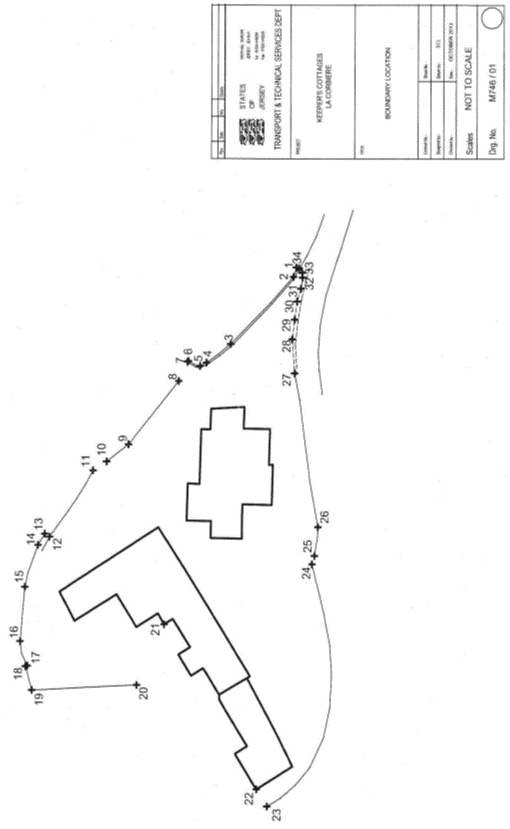
Table
|
Properties Known as Keepers
Cottages, La Rue de la Corbiue, St. Brelade.
|
|
Co-ordinate and
Descriptive Definition of the Boundary Points.
The following coordinate listing and description apply to boundary
plan number M746/01. The boundary points have coordinates currently used in
the Jersey Map Grid System 2004.
The following coordinates represent the boundary points.
|
|
Point No.
|
Easting
|
Northing
|
Description
|
|
BP01
|
32073.20E
|
65210.06N
|
Boundary Point on Northern face of concrete edging.
|
|
BP02
|
32072.08E
|
65210.39N
|
Boundary Point on
Northern face of concrete edging and 1.17 metres Westwards from BP01.
|
|
BP03
|
32064.28E
|
65217.77N
|
Boundary Point on
Northern face of concrete edging and 10.74 metres North West from BP02.
|
|
BP04
|
32062.13E
|
65220.56N
|
Boundary Point on
Northern face of concrete edging and 3.52 metres North West from BP03.
|
|
BP05
|
32061.74E
|
65221.32N
|
Boundary Point on
Northern face of concrete edging and 0.85 metres North West from BP04.
|
|
BP06
|
32062.35E
|
65222.72N
|
Boundary Point on
North Eastern corner of concrete edging and 1.53 metres Northwards from
BP05.
|
|
BP07
|
32062.24E
|
65222.82N
|
Boundary Point on
North Western corner of concrete edging and 0.15 metres North West from
BP06.
|
|
BP08
|
32059.99E
|
65223.83N
|
Boundary Point on
North Eastern corner of Wooden sleepers and 2.47 metres Westwards from
BP07.
|
|
BP09
|
32052.61E
|
65229.70N
|
Boundary Point on
Northern face of wooden sleepers and 9.42 metres North West from BP08.
|
|
BP10
|
32050.65E
|
65232.25N
|
Boundary point on
North Western end of wooden sleepers and 3.23 metres North West from
BP09.
|
|
BP11
|
32049.61E
|
65233.84N
|
Boundary point on
Northern face and Eastern end of metal fence and 1.89 metres North West
from BP10.
|
|
BP12
|
32041.97E
|
65238.90N
|
Boundary Point on
Northern face of metal fence and 9.17 metres from BP11.
|
|
BP13
|
32042.29E
|
65239.49N
|
Boundary Point on
seaward face of wall and 0.67 metres North Eastwards from BP12.
|
|
BP14
|
32041.00E
|
65240.28N
|
Boundary Point on
seaward face of wall and 1.51 metres North west from BP13.
|
|
BP15
|
32036.15E
|
65241.83N
|
Boundary Point on
seaward face of wall and 5.09 metres Westwards from BP14.
|
|
BP16
|
32029.88E
|
65242.33N
|
Boundary Point on
seaward face of wall and 6.29 metres Westwards from BP15.
|
|
BP17
|
32027.06E
|
65241.49N
|
Boundary Point on
Western end, and seaward face of wall and 2.94 metres Westwards from
BP16.
|
|
BP18
|
32026.99E
|
65241.67N
|
Boundary Point on
seaward face of property Border and 0.20 metres Northwards from BP17.
|
|
BP19
|
32024.25E
|
65240.92N
|
Boundary Point on
North Western corner of Property boundary and 2.84 metres Westwards from
BP18.
|
|
BP20
|
32024.83E
|
65228.53N
|
Boundary Point on corner
of loose stone and brick wall and 12.40 metres South East from BP19.
|
|
BP21
|
32031.87E
|
65225.35N
|
Boundary Point on corner
of building and 7. 73 metres South East from BP20.
|
|
BP22
|
32012.82E
|
65214.26N
|
Boundary Point on
South Western corner of building and 22.05 metres South West from BP21.
|
|
BP23
|
32010.83E
|
65213.00N
|
Boundary Point on
inner face of wall on a line projected from the Northern face of the building
and 2.35 metres from BP22.
|
|
BP24
|
32038.85E
|
65207.92N
|
Boundary Point on
Eastern end, and inner face of wall and 23.48 metres Eastwards from the
South West corner of building.
|
|
BP25
|
32039.78E
|
65207.64N
|
Boundary Point on
outer face of wall defining the North edge of the lighthouse access road and
0.97 South East from BP24.
|
|
BP26
|
32043.13E
|
65207.26N
|
Boundary Point on
Outer face of wall defining the North edge of the lighthouse access road and
3.38 metres South East from BP25.
|
|
BP27
|
32060.93E
|
65210.18N
|
Boundary Point on Eastern
end of wall defining the North edge of the lighthouse access road, and 18.02 metres
East from BP26.
|
|
BP28
|
32064.87E
|
65210.48N
|
Boundary Point on
Northern edge of channel situated on the North side of Lighthouse access road
and 3.96 metres East from BP27.
|
|
BP29
|
32067.16E
|
65210.21N
|
Boundary Point on
Northern edge of channel situated on the North side of lighthouse access road
2.30 metres South East from BP28.
|
|
BP30
|
32069.23E
|
65209.93N
|
Boundary Point on
Northern edge of channel situated on the North side of lighthouse access road
and 2.09 metres South East from BP29.
|
|
BP31
|
32070.70E
|
65209.54N
|
Boundary Point on
Eastern end of Northern edge of drainage channel and Western end of small
kerb line situated on the North side of lighthouse access road and 1.52 metres
South Eastwards from BP30.
|
|
BP32
|
32071.97E
|
65209.31N
|
Boundary Point on
face of small kerb line and 1.30 metres Eastwards from BP31.
|
|
BP33
|
32072.56E
|
65209.39N
|
Boundary Point on
face of small kerb line and 0.59 metres Eastwards from BP32.
|
|
BP34
|
32073.06E
|
65209.77N
|
Boundary Point on
face of small kerb line and 0.63 metres North Eastwards from BP33.
|
Part 162
Le Clos Orange
(1) The
Property known as Le Clos Orange (“the Property”), as shown on the Plan in
this Part entitled “Le Clos Orange”, to which the public has right (inter alia) by the Contracts of Purchase dated –
(a) 28th May 1976
(PR 653/388);
(b) 15th October 1976
(PR 660/302);
(c) 22nd October 1976
(PR 660/478); and
(d) 23rd December 1977
(PR 680/354),
(“Contracts of Purchase”).
(2) The
boundaries of the Property and all rights attaching thereto are set out in the
Contracts of Purchase and in sub-paragraphs (3), (4) and (5).
(3) The
walls to the south or therabouts, south-west and west or thereabouts and the
concrete kerb at the back of the pavement to the west or thereabouts of the
Property shall be transferred, without offset, to the company.
(4) The
concrete kerbing to the south of the footpath to the north of the Property
shall belong, without offset, to the public.
(5) The
wooden fences to the north or thereabouts, north-west and west-north-west and
the wall of the north-west of the sheds forming part of the Property shall all be
transferred, without offset, to the company.
NOTE:
The public administers and
maintains public foul and surface water sewers that enter the estate from the
west to the south of No. 27 Le Clos Orange where the sewers extend to
the east to a point adjacent to No. 21 Le Clos Orange. The foul sewer
only continues through to La Route Orange under a private access draining
the properties to the north and south.
The main foul and surface water
sewers extend under the estate road from the point south of No. 27
Le Clos Orange in a north-easterly direction until they reach the road
junction to the north of No. 16 and 17 Le Clos Orange where the
sewers bifurcate to the east and north with those to the east extending as far
as the junction with La Route Orange.
On the northerly branch, the surface water sewer extends only as far as
an approximate line with the pedestrian accesses to the rear of Nos. 41
and 42 Le Clos Orange. Branch foul and surface water sewers extend to the
north of Le Clos Orange Flats under the parking area to the north of the
block with the foul draining private properties to the north of Nos. 1 to
7 Le Clos Orange. The foul sewer further extends up to the estate road
junction between Nos. 41 and 42 Le Clos Orange with a small branch to
the south-west to a point adjacent to No. 38 Le Clos Orange. A
separate surface water sewer that lies to the east of Nos. 27 and 35
Le Clos Orange enters the estate to the north of the latter property and
heads in a north-easterly direction meeting with the foul sewer. The 2 sewers
then extend to the north-east to a point to the east of No. 63
Le Clos Orange where they again split. The northern branches extend under
the estate road as far as No. 67 and the easterly branches extend to a
point between Nos. 57 and 58 Le Clos Orange. At this point the foul
sewer again bifurcates with a southerly branch under the pedestrian access to
the main road to the south that drains properties along La Route Orange
with a foul sewer also heading in a south-westerly direction crossing the
gardens of Nos. 57 and 56 Le Clos Orange and draining properties on
La Route Orange to the south. The northerly branch, extending under the
curtilage and to the north-east of the dwelling of No. 58 Le Clos
Orange, drains properties to the north including La Maudelaine Estate.
The public also maintains and
administers all branch foul and surface water connections from the sewers to
the property boundaries but does not maintain or administer any road drainage
systems within the estate. Please note
that only a few properties have individual sewer connections, the majority
drain in groups via private sewers.
The current routes of the public
sewers described above are as shown on the plan in this Part entitled “Public
Sewers administered and maintained by T&TS Le Clos Orange,
St. Brelade”.
The Property is situate in the
Parish of St. Brelade in the Vingtaine de la Moye and has the
UPRN 69380239.
Le Clos Orange
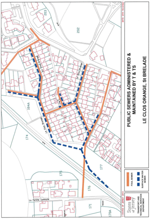
Part 163
Princess
Place, Princess Place Flats, Look Out and Rosel
(1) The
properties known as Princess Place and Princess Place Flats, Look Out and Rosel
(“the Properties”), as shown on the Plan in this Part entitled “Princess Place,
Princess Place Flats, Look Out and Rosel”, to which the public has right by the
Contracts of Purchase dated –
(a) 23rd October 1920
(PR 380/278);
(b) 27th May 1950
(PR 452A/158); and
(c) 17th January 1953
(PR 457B/161),
(“Contracts of Purchase”).
(2) The
boundaries of the Properties and all rights attaching thereto are set out
in –
(a) the Contracts of Purchase;
and
(b) the following contracts –
(i) the contract of sale dated 19th
September 1986 (PR 819/377), in so far as it relates to the public
parties to that contract,
(ii) sale by the public dated 20th
June 1997 (PR 1033/326),
(iii) sale by the public dated
5th November 2004 (PR 1176/668), and
(iv) Lease and Cession of
Wayleave Rights by the public to Jersey Electricity Plc dated 29th
July 2011 (PR 1283/24); and
(c) sub-paragraphs (3)
to (8).
(3) The
boundaries of the Properties towards FB playing fields retained by the public
shall be the wire fence which shall belong, without offset, to the public.
(4) The
boundary towards the netball courts retained by the public shall be the wall
which shall be party owned between the parties.
(5) The
boundary line separating the north western end of the access road forming part
of the Properties from the public car park retained by the public is a straight
line taken from the western corner of the wall to the north-west of Princess
Place Flats forming part of the Properties in a south-south-westerly direction
until reaching the eastern corner of the wall to the north-east of the property
known as Picardy Flats, Plat Douet Road.
(6) The
boundaries of the Properties bearing the numbers 1 to 4 The Denes retained by
the public towards the roadway known as Princess Place forming part of the
Properties shall be the walls and gate pillars forming parts of Nos. 1 to
4 The Denes which shall belong, without offset, to the public.
(7) The
boundary line separating the road forming part of 1 to 4 The Denes retained by
the public at its north-eastern end towards the roadway known as Princess Place
forming part of the Properties is a line taken from the eastern corner of the
brick pillar to the north-west of the junction of the 2 roads in a
south-easterly direction until reaching the northern corner of the concrete
pillar forming part of No. 1 The Denes to the south-east of the junction
of the 2 roads.
(8) The
boundary line separating the road forming part of 1 to 4 The Denes retained by
the public at its south-eastern end towards the roadway known as The Avenue
forming part of the Properties is a line taken from the eastern corner of the
Property called 4 The Avenue to the south-west of the junction of the 2 roads
in a north-easterly direction until reaching the southern corner of the
property called Grande Charriere Cottage to the north-east of the junction of
the 2 roads.
NOTE:
The public administers and
maintains the main public foul sewer in Princess Place from adjacent to
No. 4 The Denes in the south-east to Plat Douet Road to the north. A
public foul branch line extending off this sewer to the north-east between
Nos. 4 and 5 Princess Place and Nos. 1 and 26 Princess Place and then
extending to the south east as far as a gate leading to the F.B Fields netball
courts is also maintained and administered by the public.
The public does not maintain or
administer any branch connections from these public sewers to the buildings or
any road drainage system in the roads forming parts of the Properties.
The routes of the public sewers
described above are as shown on the plans in this Part entitled “Public Sewers
administered and maintained by T&TS Princess Place” and “Public Sewers
administered and maintained by T&TS Princess Place Flats”.
The Properties are situate in the
Parish of St. Clement in the Vingtaine de Samarès and have the
UPRNs 69386659, 69002724, 69143044 and 69143097.
Princess Place, Princess Place Flats, Look Out and Rosel
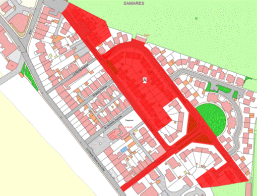
Part 164
Ann Place Mews
(1) The
property known as Ann Place Mews (“the Property”), as shown on the Plan in this
Part entitled “Ann Place Mews”, to which the public has right by the contracts
of purchase dated –
(a) 15th December 1967
(PR 538/462);
(b) 18th October 1968(PR 550/235;
(c) 4th July 1969
(PR 558/9); and
(d) 15th May 1970
(PR 568/186),
(“Contracts of Purchase”).
(2) The
boundaries of the Property and all rights attaching thereto are as set out in
the Contracts of Purchase.
NOTE:
The Property is situate in the
Parish of St. Helier in the Vingtaine de Haut de la Ville and has the
UPRN 69403646.
Ann Place Mews
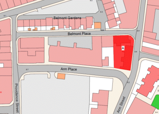
Part 165
33,
35, 37, 39 and 41 Ann Street, 65–70 Ann Court and 1 and 2 Clifton Place
(1) The
properties known as 33, 35, 37, 39 and 41 Ann Street, 65 – 70 Ann Court and
1and 2 Clifton Place (“the Properties”), as shown on the Plan in this Part
entitled “33, 35, 37, 39 and 41 Ann Street, 65–70 Ann Court and 1 and 2 Clifton
Place”, to which the public has right (inter alia)
by the contracts of purchase dated –
(a) 30th July 1960
(PR 475C/82);
(b) 23rd April 1965
(PR 500/336);
(c) 21st May 1965
(PR 501/369);
(d) 25th November 1966 (PR 523/77);
(e) 16th June 1967
(PR 531/160);
(f) 27th October 1967
(PR 536/391);
(g) 15th December 1967
(PR 538/470);
(h) 12th January 1968
(PR 540/37);
(i) 26th January 1968
(PR 540/356);
(j) 26th January 1968
(PR 540/358);
(k) 15th March 1968 (PR 542/420);
(l) 15th March 1968
(PR 542/426);
(m) 22nd March 1968
(PR 543/33);
(n) 5th April 1968
(PR 543/485);
(o) 24th May 1968
(PR 545/407);
(p) 14th June 1968
(PR 546/267);
(q) 20th September 1968
(PR 549/268);
(r) 13th December 1968
(PR 552/122);
(s) 18th July 1969
(PR 558/294);
(t) 8th August 1969
(PR 559/50);
(u) 15th August 1969
(PR 559/170);
(v) 5th December 1969
(PR 562/324);
(w) 24th April 1970
(PR 567/363);
(x) 12th June 1970
(PR 569/130);
(y) 6th November 1970
(PR 574/407);
(z) 17th December 1971
(PR 591/486);
(aa) 17th March 1972
(PR 595/245);
(ab) 15th December 1972
(PR 605/529); and
(ac) 23rd February 1973
(PR 608/331),
(“Contracts of Purchase”);
and
by compulsory purchase under
the Compulsory Purchase of land (Procedure) (Jersey) Law 1961 by Acts of
the Royal Court dated –
(ad) 6th February 1970 (PR 564/394);
(ae) 21st April 1972
(PR 597/97); and
(af) 15th February 1980
(PR 713/163),
(“Acts of the Royal
Court”).
(2) The
boundaries of the Properties and all the rights attached thereto are as set out
in –
(a) the Contracts of Purchase;
(b) the Acts of the Royal
Court; and
(c) sub-paragraph (3).
(3) The
wooden hoarding fence to the west of the Properties towards the property
retained by the public shall belong, without offset, to the public.
NOTE:
The
Properties are situate in the Parish of St. Helier in the Vingtaine de
Haut de la Ville and have the UPRNs 69386461, 69386462 and 69386626.
33, 35, 37, 39 and 41 Ann Street, 65–70 Ann Court and 1 and 2
Clifton Place
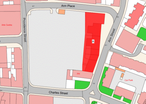
Part 166
Pomme
D’Or Farm
(1) The
Property known as Pomme D’Or Farm (“the Property”), as shown on the Plan in
this Part entitled “Pomme D’Or Farm”, to which the public has right by the contracts
of purchase dated –
(a) 4th January 1971
(PR 577/45); and
(b) 6th July 1973
(PR 614/443),
(“Contracts of Purchase”).
(2) The
boundaries of the Property and all rights attaching thereto are as set out in
the Contracts of Purchase and in sub-paragraph (3).
(3) The
wire fence and wall to the north or thereabouts, north-west and west or
thereabouts of the Property towards the property retained by the public shall
be transferred, without offset, to the company.
NOTE:
The Property is situate in the
Parish of St. Helier in the Vingtaine de Mont à l’Abbé and having the
UPRN 69408399.
Pomme D’Or Farm
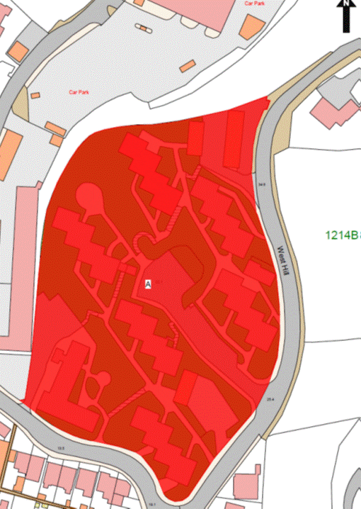
Part 167
30 and 31 Belmont Road
(1) The
properties known as 30 and 31 Belmont Road forming one corpus fundi (“the Property”), as shown on the Plan
in this Part entitled “30 and 31 Belmont Road”, to which the public has right
by the contracts of purchase dated –
(a) 8th February 1980
(PR 712/454); and
(b) 29th June 1984
(PR 781/207),
(“Contracts of Purchase”).
(2) The
boundaries of the Property and all rights attaching thereto are as set out in
the Contracts of Purchase.
NOTE:
The public maintains and
administers a large diameter surface water tunnel that lies under the Property
in a north-east to south-west direction. This sewer is approximately 20 metres below
ground level, and has been constructed through the bedrock. The Properties are
believed to drain to the public foul sewer in Belmont Road, with the drain from
No. 31 Belmont Road passing across No. 30 Belmont Road. It is
believed that No. 31 Belmont Road drains via No. 30 Belmont Road to
the public foul sewer in Belmont Road.
The current routes of the public
sewers described above are as shown on the plan in this Part entitled “Public
Sewers administered and maintained by T&TS 30 & 31 Belmont Road”.
The Property is situate in the
Parish of St. Helier in the Vingtaine du Bas du Mont-au-Prêtre and having
the UPRN 69312028.
30 and 31 Belmont Road
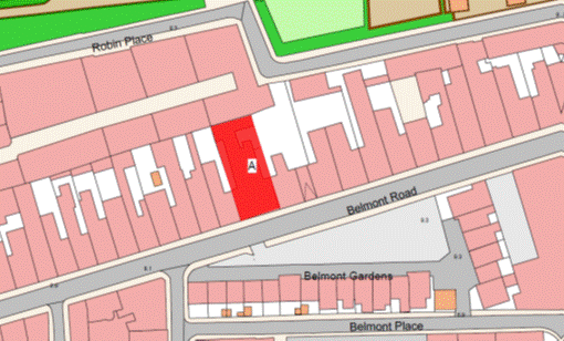
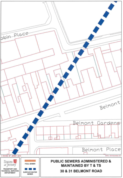
Schedule 2
(Regulation 4(3))
Contracts
and bonds
Part 1
Contracts
|
Property
|
Date of Contract
|
Public Registry Reference
|
|
1 La Cambrette
|
9 December 2005
|
1193/657
|
|
2 La Cambrette
|
9 December 2005
|
1193/667
|
|
3 La Cambrette
|
9 December 2005
|
1193/946
|
|
4 La Cambrette
|
9 December 2005
|
1193/875
|
|
5 La Cambrette
|
9 December 2005
|
1193/714
|
|
6 La Cambrette
|
9 December 2005
|
1193/922
|
|
7 La Cambrette
|
9 December 2005
|
1193/755
|
|
8 La Cambrette
|
9 December 2005
|
1193/726
|
|
9 La Cambrette
|
9 December 2005
|
1193/772
|
|
10 La Cambrette
|
9 December 2005
|
1193/898
|
|
12 La Cambrette
|
9 December 2005
|
1193/427
|
|
13 La Cambrette
|
9 December 2005
|
1193/936
|
|
14 La Cambrette
|
16 December 2005
|
1194/422
|
|
15 La Cambrette
|
6 January 2006
|
1194/947
|
|
16 La Cambrette
|
9 December 2005
|
1193/783
|
|
17 La Cambrette
|
9 December 2005
|
1193/646
|
|
18 La Cambrette
|
9 December 2005
|
1193/702
|
|
1 La Sellière
|
9 June 2006
|
1201/897
|
|
3 La Sellière
|
9 June 2006
|
1201/599
|
|
4 La Sellière
|
9 June 2006
|
1203/338
|
|
6 La Sellière
|
9 June 2006
|
1201/613
|
|
7 La Sellière
|
16 June 2006
|
1202/493
|
|
8 La Sellière
|
9 June 2006
|
1201/645
|
|
9 La Sellière
|
16 June 2006
|
1202/227
|
|
10 La Sellière
|
9 June 2006
|
1201/716
|
|
11 La Sellière
|
9 June 2006
|
1202/74
|
|
12 La Sellière
|
9 June 2006
|
1201/925
|
|
13 La Sellière
|
16 June 2006
|
1202/356
|
|
14 La Sellière
|
2 June 2006
|
1201/505
|
|
15 La Sellière
|
16 June 2006
|
1202/121
|
|
18 La Sellière
|
9 June 2006
|
1201/797
|
|
19 La Sellière
|
9 June 2006
|
1201/815
|
|
20 La Sellière
|
9 June 2006
|
1201/344
|
|
22 La Sellière
|
9 June 2006
|
1201/785
|
|
23 La Sellière
|
16 June 2006
|
1202/508
|
Part 2
Bonds
|
Property
|
Date of Borrowing
|
Public Registry Reference
|
|
4 Les Cloches
|
30 November 2007
|
128/973
|
|
5 Les Cloches
|
7 December 2007
|
128/974
|
|
6 Les Cloches
|
7 December 2007
|
128/975
|
|
7 Les Cloches
|
7 December 2007
|
128/976
|
|
8 Les Cloches
|
11 April 2008
|
130/37
|
|
9 Les Cloches
|
30 November 2007
|
128/884
|
|
10 Les Cloches
|
30 November 2007
|
128/978
|
|
13 Les Cloches
|
13 June 2008
|
130/687
|
|
14 Les Cloches
|
8 August 2008
|
131/312
|
|
15 Les Cloches
|
7 December 2007
|
128/967
|
|
16 Les Cloches
|
30 November 2007
|
128/885
|
|
17 Les Cloches
|
14 December 2007
|
129/100
|
|
18 Les Cloches
|
14 December 2007
|
129/99
|
|
19 Les Cloches
|
7 December 2007
|
128/966
|
|
20 Les Cloches
|
18 April 2008
|
130/125
|
|
21 Les Cloches
|
7 December 2007
|
128/977
|
|
22 Les Cloches
|
8 February 2008
|
129/466
|
|
23 Les Cloches
|
25 April 2008
|
130/196
|
|
24 Les Cloches
|
7 December 2007
|
129/98
|
|
26 Les Cloches
|
25 April 2008
|
130/200
|
|
27 Les Cloches
|
18 April 2008
|
130/126
|
|
28 Les Cloches
|
18 April 2008
|
130/127
|
|
29 Les Cloches
|
18 April 2008
|
130/124
|
|
30 Les Cloches
|
25 April 2008
|
130/199
|
|
31 Les Cloches
|
11 April 2008
|
130/36
|
|
32 Les Cloches
|
14 December 2007
|
129/103
|
|
33 Les Cloches
|
21 December 2007
|
129/156
|
|
34 Les Cloches
|
7 December 2007
|
128/797
|
|
35 Les Cloches
|
25 April 2008
|
130/198
|
|
36 Les Cloches
|
7 December 2007
|
128/968
|
|
38 Les Cloches
|
1 August 2008
|
131/250
|
|
39 Les Cloches
|
21 December 2007
|
129/155
|
|
40 Les Cloches
|
4 April 2008
|
129/963
|
|
41 Les Cloches
|
14 December 2007
|
129/102
|
|
42 Les Cloches
|
7 December 2007
|
128/980
|
|
43 Les Cloches
|
16 May 2008
|
130/357
|
|
47 Les Cloches
|
14 December 2007
|
129/101
|
|
48 Les Cloches
|
18 April 2008
|
130/123
|
|
49 Les Cloches
|
27 June 2008
|
130/817
|
|
2 Balleine Close
|
22 October 2010
|
137/228
|
|
5 Balleine Close
|
10 September 2010
|
136/917
|
|
Tradewinds, South Hill
|
15 April 2011
|
137/228
|
|
1 Grasett Park
|
15 July 2011
|
139/151
|
|
2 Grasett Park
|
31 January 2014
|
145/638
|
|
5 Grasett Park
|
4 April 2014
|
146/98
|
|
6 Grasett Park
|
26 September 2008
|
131/686
|
|
9 Grasett Park
|
3 October 2008
|
131/751
|
|
14 Grasett Park
|
29 November 2013
|
145/237
|
|
16 Grasett Park
|
26 February 2010
|
135/399
|
|
17 Grasett Park
|
3 May 2013
|
143/719
|
|
18 Grasett Park
|
3 April 2009
|
132/976
|
|
26 Grasett Park
|
29 November 2013
|
145/236
|
|
27 Grasett Park
|
24 February 2012
|
140/774
|
|
33 Grasett Park
|
28 August 2009
|
134/190
|
|
42 Grasett Park
|
19 June 2009
|
133/524
|
|
43 Grasett Park
|
5 July 2013
|
144/157
|
|
48 Grasett Park
|
16 January 2008
|
132/409
|
|
52 Grasett Park
|
14 May 2010
|
135/978
|
|
53 Grasett Park
|
12 September 2008
|
131/551
|
|
54 Grasett Park
|
28 February 2014
|
145/837
|
|
59 Grasett Park
|
28 October 2011
|
139/913
|
|
63 Grasett Park
|
21 May 2010
|
136/19
|
|
69 Grasett Park
|
19 June 2009
|
133/525
|
|
70 Grasett Park
|
24 April 2009
|
133/110
|
|
71 Grasett Park
|
19 July 2013
|
144/273
|
|
74 Grasett Park
|
18 July 2008
|
131/109
|
|
80 Grasett Park
|
8 February 2008
|
129/467
|
|
3 Bel Gaudin (Bashfords)
|
3 June 2011
|
138/794
|
|
6 Bel Gaudin (Bashfords)
|
25 April 2014
|
146/211
|
|
26 Rue Carteret (Bashfords)
|
23 October 2009
|
134/589
|
|
1 Place Le Couteur (Gorey Village)
|
15 June 2012
|
141/595
|
|
1 Le Bel Collas (Gorey Village)
|
23 May 2008
|
130/455
|
|
2 Le Bel Collas (Gorey Village)
|
6 December 2013
|
145/303
|
|
11 Les Hoummets (Gorey Village)
|
23 May 2008
|
130/456
|
|
2 Oak Tree Gardens
|
2 January 2009
|
132/341
|
|
3 Oak Tree Gardens
|
2 January 2009
|
132/339
|
|
15 Oak Tree Gardens
|
16 January 2009
|
132/408
|
|
25 Oak Tree Gardens
|
18 October 2013
|
144/918
|
|
26 Oak Tree Gardens
|
14 February 2014
|
145/741
|
|
27 Oak Tree Gardens
|
6 March 2009
|
132/763
|
|
37 Oak Tree Gardens
|
3 April 2009
|
132/977
|
|
38 Oak Tree Gardens
|
9 January 2009
|
132/368
|
|
39 Oak Tree Gardens
|
2 January 2009
|
132/340
|
|
47 Oak Tree Gardens
|
4 September 2009
|
134/246
|
|
53 Oak Tree Gardens
|
4 November 2011
|
139/992
|
|
54 Oak Tree Gardens
|
6 December 2013
|
145/302
|
|
78 Oak Tree Gardens
|
29 November 2013
|
145/238
|
|
2 La Providence
|
31 July 2009
|
133/953
|
|
5 La Providence
|
16 October 2009
|
134/529
|
|
7 La Providence
|
20 November 2009
|
134/785
|
|
8 La Providence
|
7 August 2009
|
134/22
|
|
9 La Providence
|
16 October 2009
|
134/530
|
|
10 La Providence
|
17 July 2009
|
133/767
|
|
12 La Providence
|
31 July 2009
|
133/955
|
|
13 La Providence
|
17 July 2009
|
133/765
|
|
14 La Providence
|
24 July 2009
|
133/866
|
|
15 La Providence
|
17 July 2009
|
133/774
|
|
17 La Providence
|
14 August 2009
|
134/81
|
|
18 La Providence
|
17 July 2009
|
133/768
|
|
19 La Providence
|
17 July 2009
|
133/772
|
|
20 La Providence
|
14 August 2009
|
134/80
|
|
21 La Providence
|
17 July 2009
|
133/773
|
|
22 La Providence
|
31 July 2009
|
133/952
|
|
23 La Providence
|
31 July 2009
|
133/956
|
|
24 La Providence
|
24 July 2009
|
133/855
|
|
25 La Providence
|
24 July 2009
|
133/865
|
|
29 La Providence
|
24 July 2009
|
133/868
|
|
33 La Providence
|
7 August 2009
|
134/21
|
|
34 La Providence
|
24 July 2009
|
133/859
|
|
36 La Providence
|
27 November 2009
|
134/840
|
|
37 La Providence
|
24 July 2009
|
133/858
|
|
38 La Providence
|
17 July 2009
|
133/775
|
|
39 La Providence
|
31 July 2009
|
133/954
|
|
40 La Providence
|
24 July 2009
|
133/861
|
|
41 La Providence
|
4 December 2009
|
134/906
|
|
42 La Providence
|
24 July 2009
|
133/856
|
|
44 La Providence
|
24 July 2009
|
133/857
|
|
45 La Providence
|
24 July 2009
|
133/864
|
|
63 La Providence
|
24 July 2009
|
133/862
|
|
65 La Providence
|
31 July 2009
|
133/957
|
|
66 La Providence
|
18 December 2009
|
135/42
|
|
67 La Providence
|
24 July 2009
|
133/860
|
|
68 La Providence
|
6 November 2009
|
134/700
|
|
69 La Providence
|
17 July 2009
|
133/769
|
|
70 La Providence
|
24 July 2009
|
133/867
|
|
71 La Providence
|
24 July 2009
|
133/863
|
|
77 La Providence
|
14 August 2009
|
134/79
|
|
78 La Providence
|
29 January 2010
|
135/213
|
|
79 La Providence
|
17 July 2009
|
133/766
|
|
82 La Providence
|
31 July 2009
|
133/951
|
|
83 La Providence
|
17 July 2009
|
133/771
|
|
84 La Providence
|
24 July 2009
|
133/869
|
|
85 La Providence
|
17 July 2009
|
133/770
|
|
108 Clos des Sables
|
25 April 2008
|
130/197
|