Schedule
(Regulation 4)
Part 1
Terms and conditions of
transfer of immovable property
1 Interpretation
In this Schedule –
“BP” together
with a number means a boundary point of that number shown on a Co-Ordinate
Point Plan;
“Co-Ordinate Point
Plan” in respect of any piece of transfer property in Part 2 of this
Schedule means a plan –
(a) included in this Schedule;
(b) showing
boundary points delineating the boundary of that piece; and
(c) marked
with the letter “M” together with the number mentioned in the
description of that piece;
“Jersey Digital
Map” means the digital map held in the Jersey Mapping System of the
Planning and Environment Department;
“maintain” in
relation to a drain or sewer has the meaning given by Article 1(1) of the Drainage (Jersey)
Law 2005;
“offset” has
the same meaning as “relief” in Jersey customary law;
“parties”
means –
(a) the
States and the Public; and
(b) POJL;
“plan” without
more and in respect of any piece of transfer property in Part 2 of this
Schedule means a plan –
(a) included
in this Schedule;
(b) identifying
the piece in question by a hatched or shaded area; and
(c) marked
with the letters “AIP” together with the number mentioned in the
description of that piece;
“PR” means,
together with a number, the Public Registry Book and Folio Number of a property
contract recorded in the Public Registry;
“Public
Registry” means the office of the Judicial Greffe for the enrolment of
public records relating to hereditary property contracts;
“sewer” and
“sewage disposal works” have the meanings given to those
expressions respectively by Article 1(1) of the Drainage (Jersey) Law 2005;
“UPRN”
together with a number means the Unique Property Reference Number allocated to
a property in the Jersey Mapping System of the Planning and Environment
Department.
2 General terms of transfer:
alienation
(1) No
part of the transfer property described in Part 2 of this Schedule (in
this paragraph, the “transfer property”) shall be alienated or
hypothecated by POJL at any time or in any manner whatever without –
(a) the
prior written consent of the Public; and
(b) in
the case of a proposed alienation, compliance with paragraph (2).
(2) Where
POJL proposes to alienate the transfer property, or any part of it, it shall
first offer in writing to the Public to dispose of the property in question to
the Public and the Public may accept or decline such offer on such terms as the
Public may in its absolute discretion determine.
(3) The
restriction imposed by paragraph (1) shall not prevent POJL from entering
into a lease or licence of any part of the transfer property to any third party
for a term not exceeding 125 years.
3 Assets transferred to
POJL: general terms of transfer, rights and reservations
(1) The
immovable assets described in Part 2 of this Schedule and all rights and
liabilities of the States or of the Public in respect of those assets shall be
transferred to POJL in the state in which they are, and with all their apparent
or hidden defects (vices cachés) if
any, on the transfer date, and with such benefits as are conferred under
Article 45 of the Loi
(1880) sur la propriété foncière on a transfer.
(2) The
other assets of the States or of the Public in the form of property described
in Part 3 of this Schedule shall be transferred to POJL subject to and
together with all such rights and liabilities, as they were when under the
control or administration of the States or the Public immediately before the
transfer date.
(3) Unless
specifically provided otherwise, all contracts, leases, deeds, agreements and
other instruments subsisting in favour of, or against, and all notices in force
which were given (or have effect as if they had been given) by, or on behalf
of, or to, the States or the Public in respect of any asset or liability, shall
be of full force and effect in favour of, or (as the case may be) against,
POJL.
(4) Where
immediately before the transfer date there is in force an agreement which
confers or imposes on the States or the Public rights or liabilities which were
exclusively in respect of the States or the Public and which are transferred to
POJL by virtue of the Law and these Regulations, that agreement shall have
effect on and after that date as if –
(a) POJL
had been a party to the agreement; and
(b) for a
reference (in whatever terms and whether express or implied) to the States or
the Public there were substituted, in relation to anything falling to be done
on or after that date, a reference to POJL.
(5) Any
action or proceeding or any cause of action or proceedings, pending or existing
on the transfer date by or against the States or the Public in respect of any
property, rights or liabilities transferred by the Law and these Regulations
shall not be prejudicially affected by reason of the transfer, and may be
continued, prosecuted and enforced by, or (as the case may be) against, POJL.
(6) For
the avoidance of doubt the property, rights and liabilities transferred by
these Regulations shall include –
(a) intellectual
property rights, whether registered or not; and
(b) any
documents or other records relevant to the property transferred.
4 Immovable assets
transferred to POJL: rights and liabilities
(1) The
rights and liabilities in immovable assets are transferred as described in
sub-paragraphs (2) to (16).
(2) Except
as otherwise stated in Part 2 of this Schedule, the walls, fences, banks,
hedges, gates, gate pillars, walls of buildings and concrete kerbs or brick
edging at ground level forming the boundaries of any property are transferred
without offset to POJL.
(3) Any
sewers and sewage disposal works described in Part 2 of this Schedule the
routes of which are shown on plans in Part 2 of this Schedule entitled
“Public Sewers administered and maintained by T&TS” shall not
be transferred to POJL and shall be deemed to be public sewers or public sewage
disposal works, as defined in the Drainage (Jersey)
Law 2005, as if the facility had been declared and adopted as a public
sewer or public sewage disposal works in accordance with Article 12 of
that Law.
(4) Except
as otherwise stated in Part 2 of this Schedule, the Public shall
have –
(a) the
right to keep, maintain, clean, unblock, renew, repair and replace any drainage
pipes, inspection covers or other drainage apparatus as at present established
through, in and under any property in order to drain waste water, sewage and
surface water emanating from any property belonging to the Public in the
vicinity of any of the properties;
(b) a
right of access at all times and whenever necessary, with or without workmen,
tools, machinery and vehicles on to the transfer property in order to carry out
any of the works described in clause (a); and
(c) the
right to keep any property belonging to the Public connected as at the transfer
date to any foul drainage system or surface water drainage system which forms
part of any transfer property, together with the right to drain –
(i) waste water and
sewage emanating from any property belonging to the Public through such foul
drainage system forming any part of the transfer property, and
(ii) surface
water emanating from any property belonging to the Public through such surface
water drainage system forming any part of the transfer property.
(5) Except
as otherwise stated in Part 2 of this Schedule, POJL shall have –
(a) the
right to keep, maintain, clean, unblock, renew, repair and replace any drainage
pipes, inspection covers or other drainage apparatus as at present established
through, in and under any property belonging to the Public in the vicinity of
any transfer property in order to drain waste water, sewage and surface water
emanating from any transfer property;
(b) a
right of access at all times and whenever necessary with or without workmen,
tools, machinery and vehicles on to any property retained by the Public in
order to carry out any of the works described in clause (a); and
(c) the
right to keep any property belonging to POJL connected as at the transfer date
to any foul drainage system or surface water drainage system belonging to the
Public, together with the right to drain –
(i) waste water and
sewage emanating from any property belonging to POJL through such foul drainage
system belonging to the Public, and
(ii) surface
water emanating from any property belonging to POJL through such surface water
drainage system belonging to the Public.
(6) Except
as otherwise stated in Part 2 of this Schedule, the Public shall
have –
(a) the
right to keep, maintain, clean, unblock, repair, replace and relocate any
pipes, cables, conduits or any other apparatus as at present established
through, in and under any transfer property in order to supply mains services
of electricity, water, gas, telephone and any other service it deems necessary
to any property it owns in the vicinity of a transfer property; and
(b) a
right of access at all times and whenever necessary, with or without workmen,
tools, machinery and vehicles on to any transfer property in order to carry out
any of the works described in clause (a).
(7) Except
as otherwise stated in Part 2 of this Schedule, POJL shall
have –
(a) the
right to keep, maintain, clean, unblock, repair, replace and relocate any
pipes, cables, conduits or any other apparatus as at present established
through, in and under any property owned by the Public in the vicinity of any transfer
property in order to supply mains services of electricity, water, gas,
telephone and any other service it deems necessary to any transfer property;
and
(b) a
right of access at all times and whenever necessary, with or without workmen,
tools, machinery and vehicles, on to any property owned by the Public in order
to carry out any of the works described in clause (a).
(8) Except
as otherwise stated in Part 2 of this Schedule, the parties shall have
reciprocal rights to keep, repair, replace, paint or clean any parts of any
building, structure, or boundary enclosure, including any wall, gables, hedges,
fences, banks, foundations, balconies, roof parts, downpipes, guttering, fascia
boards, soffits, windows, windowsills, doors, gates, air vents or other openings
as they were established before the coming into force of these Regulations,
notwithstanding that they might overhang or encroach onto or be less than
3 Jersey feet from any transfer property or any property owned by the
Public.
(9) Except
as otherwise stated in Part 2 of this Schedule, the parties shall have
such reciprocal rights to join on to, into or against any gable, wall or
boundary enclosure belonging to the other party for any wall, gable, boundary
enclosure, building or other structure as existed before the coming into force
of these Regulations.
(10) Except
as otherwise stated in Part 2 of this Schedule, the parties shall have the
right to keep from overhanging any tree or bush that is growing close to the
boundary on any property belonging to the other party and shall have a right of
access at all reasonable times to the property of the other party in order to
prune, cut, pollard, trim and maintain the overhanging parts of any such tree
or bush.
(11) Except
as otherwise stated in Part 2 of this Schedule, each party shall have a
reciprocal right of access onto any property of the other party in
order –
(a) to
build, rebuild, replace, raise the height of, repair or maintain any wall,
construction or appurtenance built or established or which might in the future
be built or established on the party’s own property and which cannot
conveniently be carried out on or from its own property; or
(b) to
carry out any work described in Part 2 of this Schedule.
(12) The
right of access granted to a party under paragraph (11)(a) –
(a) shall
be subject to and limited by any construction, structure or other thing which
may from time to time be built or established on the property of the other
party;
(b) shall
only be exercised on the accessible parts from time to time of the property of
the other party;
(c) shall
not limit in any way the right of either party from time to time to construct
or establish any construction, structure or other thing on its property;
(d) shall
be exercised only after the party has given at least 2 weeks’ prior
written notice to the other party (except in an emergency, where no notice is
required);
(e) shall
be exercised only when or where necessary;
(f) shall
be exercised, with or without workmen, materials, ladders, scaffolding, equipment
or machinery, in the most expeditious manner possible and causing the least
possible inconvenience or prejudice to the other party.
(13) The
party exercising a right of access granted under paragraph (11) shall as
soon as possible after the completion of the works restore any affected areas
of the property of the other party to the equivalent state and condition it was
in immediately before the works.
(14) The
party exercising a right of access shall indemnify and keep indemnified the
other party against all liabilities, losses, proceedings, costs or claims
whatsoever with regard to its liability imposed by law for any death or bodily
injury arising from any accident, and for all damage to property, arising from
or attributable to the exercising of such right of access.
(15) Before
exercising a right of access (other than in an emergency) –
(a) the
party exercising that right shall put in place appropriate public liability
insurance in an amount agreed with the other party and shall provide the other party
with a copy of the insurance policy (or reasonable evidence of the terms of
such policy); and
(b) in
the event that the parties are not able to agree the level of indemnity
insurance, the question shall be referred to the arbitration of a suitably qualified
arbitrator nominated by agreement between both parties or failing such
agreement on the application of either party to the President for the time
being of the Royal Institution of Chartered Surveyors with the decision of such
arbitration including any award as to costs to be final and binding on the
parties.
(16) A
party whose property is subject to any right under Part 2 of this Schedule
gives no guarantee or affirmation whatsoever as to the condition, security or
suitability of any part of its property for the exercise of the right or the
purpose for which the right is exercised.
Part 2
Immovable property transferred
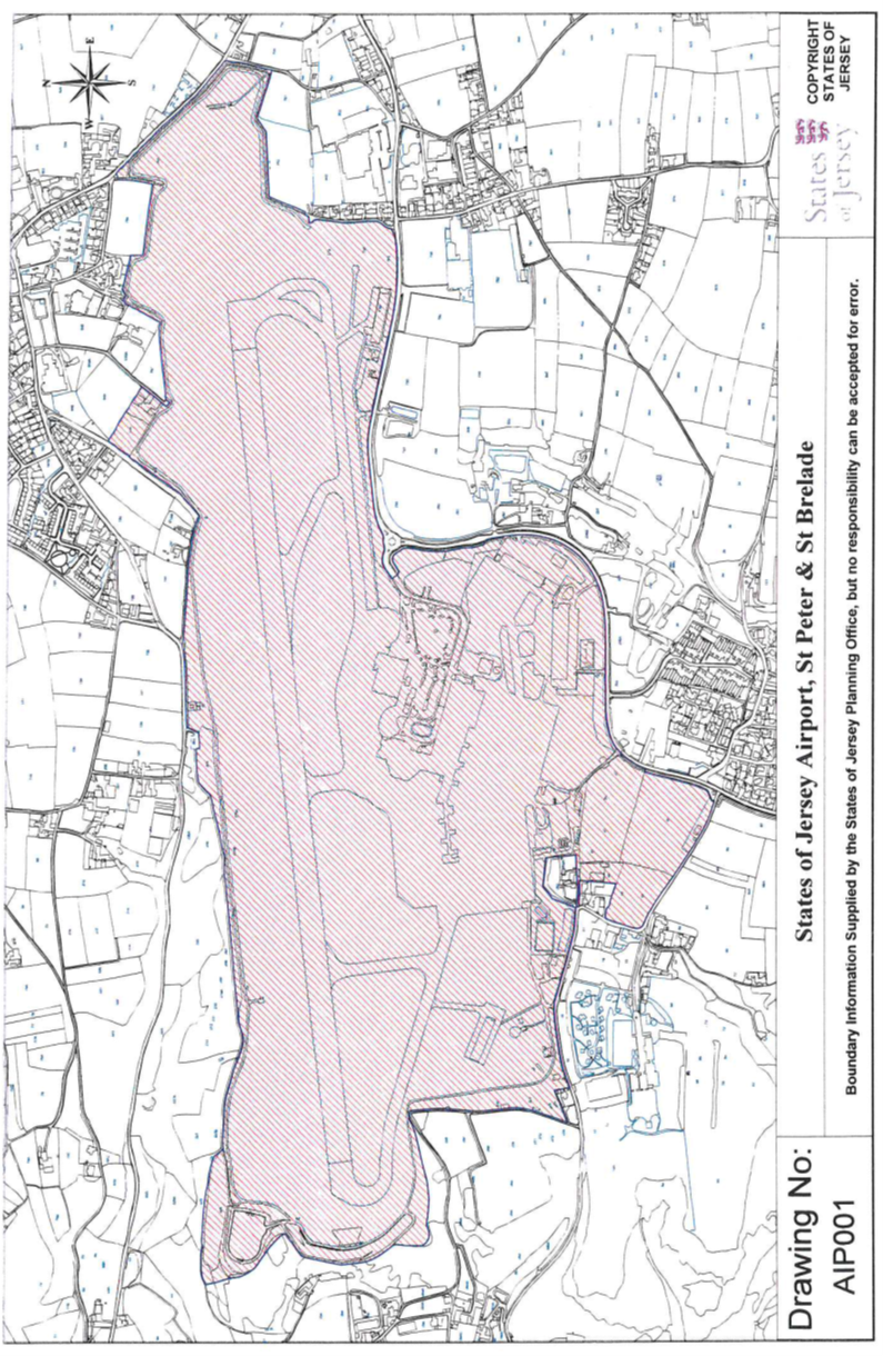
1 Jersey Airport,
St. Peter and St. Brelade
(1) The
property called “Jersey Airport” (the “Airport”) and
situate partly in the Grande Vingtaine and Vingtaine de Douet in the Parish of
St. Peter and the remainder in the Vingtaine des Quennevais in the Parish
of St. Brelade comprising the land with ancillary buildings structures and
all other appurtenances and shown on the Plan marked AIP001
with the boundaries described in sub-paragraph (3) –
(a) as
to clauses (a) to (g) by Boundary Points numbered BP01 to BP155 inclusive such as they are
set out on the Co-Ordinate Point Plans dated December 2013 and the Co-Ordinate Point
Listings hereinafter appearing and marked M663/01, M663/01a, M663/02,
M663/03, M663/04, M663/05, M663/06, M663/07, M663/08 and M663/09 respectively; and
(b) as
to clauses (h) and (i) by Boundary Points numbered BP01 to BP13 inclusive such as they are
set out on the Co-Ordinate Point Plan dated December 2013 and the
Co-Ordinate Point Listing hereinafter appearing and both marked M663/10.
(2) The
Public is entitled to the Airport –
(a) partly
by the following 223 contracts of acquisition –
|
Date
|
Reference
|
|
11th
August 1934
|
(PR
422/10)
|
|
11th
August 1934
|
(PR
422/11)
|
|
11th
August 1934
|
(PR
422/13)
|
|
11th
August 1934
|
(PR
422/13)
|
|
11th
August 1934
|
(PR
422/12)
|
|
11th
August 1934
|
(PR
422/14)
|
|
11th
August 1934
|
(PR
422/15)
|
|
11th
August 1934
|
(PR
422/16)
|
|
11th
August 1934
|
(PR
422/17)
|
|
11th
August 1934
|
(PR
422/18)
|
|
11th
August 1934
|
(PR
422/19)
|
|
11th
August 1934
|
(PR
422/20)
|
|
11th
August 1934
|
(PR
422/20)
|
|
11th
August 1934
|
(PR
422/21)
|
|
11th
August 1934
|
(PR
422/22)
|
|
11th
August 1934
|
(PR
422/22)
|
|
11th
August 1934
|
(PR
422/23)
|
|
11th
August 1934
|
(PR
422/24)
|
|
11th
August 1934
|
(PR
422/25)
|
|
11th
August 1934
|
(PR
422/26)
|
|
11th
August 1934
|
(PR
422/27)
|
|
11th
August 1934
|
(PR
422/28)
|
|
11th
August 1934
|
(PR
422/28)
|
|
11th
August 1934
|
(PR
422/29)
|
|
11th
August 1934
|
(PR
422/30)
|
|
11th
August 1934
|
(PR
422/31)
|
|
11th
August 1934
|
(PR
422/32)
|
|
11th
August 1934
|
(PR
422/33)
|
|
11th
August 1934
|
(PR
422/33)
|
|
13th
August 1934
|
(PR
422/64)
|
|
13th
August 1934
|
(PR
422/65)
|
|
22nd
September 1934
|
(PR
422/213)
|
|
22nd
September 1934
|
(PR
422/214)
|
|
22nd
September 1934
|
(PR
422/215)
|
|
22nd
September 1934
|
(PR
422/217)
|
|
22nd
September 1934
|
(PR
422/219)
|
|
22nd
September 1934
|
(PR
422/220)
|
|
26th
September 1934
|
(PR
422/238)
|
|
6th
October 1934
|
(PR
422/286)
|
|
6th
October 1934
|
(PR
422/287)
|
|
6th
October 1934
|
(PR
422/288)
|
|
6th
October 1934
|
(PR
422/289)
|
|
6th
October 1934
|
(PR
422/291)
|
|
6th
October 1934
|
(PR
422/291)
|
|
6th
October 1934
|
(PR
422/293)
|
|
6th
October 1934
|
(PR
422/294)
|
|
6th
October 1934
|
(PR
422/296)
|
|
6th
October 1934
|
(PR
422/297)
|
|
6th
October 1934
|
(PR
422/299)
|
|
9th
October 1934
|
(PR
423/1)
|
|
9th
October 1934
|
(PR
423/3)
|
|
13th
October 1934
|
(PR
423/10)
|
|
13th
October 1934
|
(PR
423/11)
|
|
3rd
November 1934
|
(PR
423/117)
|
|
23rd
February 1935
|
(PR
424/245)
|
|
23rd
February 1935
|
(PR
424/246)
|
|
23rd
February 1935
|
(PR
424/246)
|
|
9th
March 1935
|
(PR
424/279)
|
|
9th
March 1935
|
(PR
424/280)
|
|
9th
March 1935
|
(PR
424/280)
|
|
6th
April 1935
|
(PR
425/67)
|
|
27th
April 1935
|
(PR
425/115)
|
|
27th
April 1935
|
(PR
425/116)
|
|
27th
April 1935
|
(PR
425/117)
|
|
27th
April 1935
|
(PR
425/118)
|
|
27th
April 1935
|
(PR
425/119)
|
|
27th
April 1935
|
(PR
425/120)
|
|
27th
April 1935
|
(PR
425/121)
|
|
27th
July 1935
|
(PR
426/165)
|
|
27th
July 1935
|
(PR
426/166)
|
|
27th
July 1935
|
(PR
426/166)
|
|
21st
September 1935
|
(PR
427/59)
|
|
16th
January 1937
|
(PR
430B/144)
|
|
30th
January 1937
|
(PR
430B/169)
|
|
13th
February 1937
|
(PR
430B/186)
|
|
3rd
April 1937
|
(PR
430B/278)
|
|
1st
May 1937
|
(PR
431B/61)
|
|
1st
May 1937
|
(PR
431B/63)
|
|
9th
December 1939
|
(PR
436B/35)
|
|
9th
December 1939
|
(PR
436B/35)
|
|
23rd
December 1939
|
(PR
436B/50)
|
|
23rd
December 1939
|
(PR
436B/51)
|
|
23rd
December 1939
|
(PR
436B/52)
|
|
23rd
December 1939
|
(PR
436B/53)
|
|
20th
January 1940
|
(PR
436B/81)
|
|
30th
March 1940
|
(PR
436B/172)
|
|
12th
January 1946
|
(PR
442B/166)
|
|
24th
July 1948
|
(PR
448C/283)
|
|
24th
July 1948
|
(PR448C/285)
|
|
24th
July 1948
|
(PR
449C/1)
|
|
7th
August 1948
|
(PR
449B/7)
|
|
21st
August 1948
|
(PR
449C/44)
|
|
21st
August 1948
|
(PR
449C/45)
|
|
21st
August 1948
|
(PR
449C/46)
|
|
21st
August 1948
|
(PR
449C/47)
|
|
21st
August 1948
|
(PR
449C/48)
|
|
21st
August 1948
|
(PR
449C/50)
|
|
4th
September 1948
|
(PR
449A/48)
|
|
4th
September 1948
|
(PR
449A/50)
|
|
4th
September 1948
|
(PR
449A/51)
|
|
4th
September 1948
|
(PR
449A/53)
|
|
4th
September 1948
|
(PR
449A/54)
|
|
13th
November 1948
|
(PR
449C/172)
|
|
18th
December 1948
|
(PR
449B/235)
|
|
18th
December 1948
|
(PR
449B/236)
|
|
19th
February 1949
|
(PR
450A/52)
|
|
19th
February 1949
|
(PR
450A/52)
|
|
23rd
April 1949
|
(PR
450C/142)
|
|
4th
May 1949
|
(PR
450B/158)
|
|
21st
May 1949
|
(PR
450C/185)
|
|
21st
May 1949
|
(PR
450C/185)
|
|
21st
May 1949
|
(PR
450C/186)
|
|
4th
June 1949
|
(PR
450A/203)
|
|
4th
June 1949
|
(PR
450A/204)
|
|
4th
June 1949
|
(PR
450A/205)
|
|
4th
June 1949
|
(PR
450A/208)
|
|
4th
June 1949
|
(PR
450A/209)
|
|
4th
June 1949
|
(PR
450A/210)
|
|
4th
June 1949
|
(PR
450A/212)
|
|
4th
June 1949
|
(PR
450A/213)
|
|
18th
June 1949
|
(PR
450A/225)
|
|
18th
June 1949
|
(PR
450A/226)
|
|
18th
June 1949
|
(PR
450A/228)
|
|
18th
June 1949
|
(PR
450A/231)
|
|
18th
June 1949
|
(PR
450A/231)
|
|
10th
September 1949
|
(PR
451C/63)
|
|
24th
September 1949
|
(PR
451C/77)
|
|
24th
September 1949
|
(PR
451C/78)
|
|
1st
October 1949
|
(PR
451B/76)
|
|
8th
October 1949
|
(PR
451B/85)
|
|
8th
October 1949
|
(PR
451B/86)
|
|
22nd
October 1949
|
(PR
451C/116)
|
|
22nd
October 1949
|
(PR
451C/117)
|
|
5th
November 1949
|
(PR
451A/131)
|
|
10th
December 1949
|
(PR
451C/216)
|
|
17th
December 1949
|
(PR
451A/234)
|
|
28th
January 1950
|
(PR
451B/280)
|
|
28th
January 1950
|
(PR
451B/282)
|
|
29th
April 1950
|
(PR
452B/120)
|
|
13th
May 1950
|
(PR
452A/147)
|
|
10th
June 1950
|
(PR
452B/185)
|
|
24th
June 1950
|
(PR
452A/206)
|
|
2nd
September 1950
|
(PR
453A/3)
|
|
2nd
September 1950
|
(PR
453A/4)
|
|
16th
September 1950
|
(PR
453A/20)
|
|
16th
September 1950
|
(PR
453A/21)
|
|
30th
September 1950
|
(PR
453A/36)
|
|
17th
March 1951
|
(PR
453C/263)
|
|
29th
September 1951
|
(PR
454A/245)
|
|
27th
March 1954
|
(PR
459B/229)
|
|
27th
March 1954
|
(PR
459B/230)
|
|
5th
March 1955
|
(PR
461A/160)
|
|
19th
March 1955
|
(PR
461A/176)
|
|
7th
April 1956
|
(PR
464C/23)
|
|
25th
May 1957
|
(PR
465A/278)
|
|
6th
July 1957
|
(PR
466C/160)
|
|
6th
July 1957
|
(PR
466C/162)
|
|
17th
August 1957
|
(PR
466A/130)
|
|
12th
October 1957
|
(PR
466A/198)
|
|
8th
February 1958
|
(PR
467B/101)
|
|
8th
February 1958
|
(PR
467B/102)
|
|
15th
February 1958
|
(PR
467A/143)
|
|
15th
February 1958
|
(PR
467A/144)
|
|
1st
March 1958
|
(PR
467C/278)
|
|
1st
March 1958
|
(PR
467C/277)
|
|
1st
March 1958
|
(PR
467C/280)
|
|
15th
March 1958
|
(PR
468C/33)
|
|
15th
March 1958
|
(PR
468C/35)
|
|
15th
March 1958
|
(PR
468C/36)
|
|
22nd
March 1958
|
(PR
467B/197)
|
|
29th
March 1958
|
(PR
468C/64)
|
|
29th
March 1958
|
(PR
468C/65)
|
|
16th
May 1959
|
(PR
470B/235)
|
|
23rd
May 1959
|
(PR
470B/258)
|
|
23rd
May 1959
|
(PR
470B/259)
|
|
30th
May 1959
|
(PR
471C/120)
|
|
27th
June 1959
|
(PR
471A/64)
|
|
5th
September 1959
|
(PR
472C/109)
|
|
24th
October 1959
|
(PR
472A/1)
|
|
19th
November 1965
|
(PR
507/484)
|
|
22nd
April 1966
|
(PR
513/333)
|
|
7th
October 1966
|
(PR
521/91)
|
|
7th
April 1967
|
(PR
528/339)
|
|
6th
October 1967
|
(PR
535/398)
|
|
17th
November 1967
|
(PR
537/331)
|
|
9th
February 1968
|
(PR
541/99)
|
|
31st
May 1968
|
(PR
546/113)
|
|
14th
June 1968
|
(PR
546/269)
|
|
6th
September 1968
|
(PR
549/83)
|
|
15th
November 1968
|
(PR
551/214)
|
|
3rd
January 1969
|
(PR
553/44)
|
|
15th
May 1970
|
(PR
568/191)
|
|
10th
December 1971
|
(PR
591/227)
|
|
28th
January 1972
|
(PR
593/183)
|
|
25th
August 1972
|
(PR
601/215)
|
|
22nd
March 1974
|
(PR
623/413)
|
|
6th
December 1974
|
(PR
632/88)
|
|
14th
February 1975
|
(PR
634/335)
|
|
18th
April 1975
|
(PR
637/25)
|
|
6th
June 1975
|
(PR
638/596)
|
|
13th
August 1976
|
(PR
657/336)
|
|
21st
January 1977
|
(PR
664/341)
|
|
4th
March 1977
|
(PR
666/38)
|
|
3rd
February 1978
|
(PR
682/319)
|
|
23rd
June 1978
|
(PR
689/549)
|
|
27th
October 1978
|
(PR
695/487)
|
|
6th
July 1979
|
(PR
704/684)
|
|
1st
May 1981
|
(PR
728/254)
|
|
9th
October 1981
|
(PR
734/196)
|
|
29th
January 1982
|
(PR
738/622)
|
|
23rd
March 1984
|
(PR
776/591)
|
|
4th
October 1991
|
(PR
907/1)
|
|
27th
November 1992
|
(PR
930/296)
|
|
4th
March 1994
|
(PR
960/1)
|
|
27th
May 1994
|
(PR
965/495)
|
|
29th
September 1995
|
(PR
996/412)
|
|
27th
November 1996
|
(PR
1022/444)
|
|
26th
September 1997
|
(PR
1039/182)
|
|
19th
June 1998
|
(PR
1055/49)
|
|
19th
May 2000
|
(PR
1099/84)
|
|
27th
July 2001
|
(PR
1122/102)
|
|
21st
September 2001
|
(PR
1124/796)
|
|
10th
October 2003
|
(PR
1160/947)
|
(b) as
to the remainder by peaceable undisturbed title and possession of in excess of
40 years (“possession quadragenaire”) “nec
vi, nec clam, nec precario”; and
(c) in
relation to all such public highways and parts of highways as are within the
Airport, by virtue of the provisions of Article 47 of the Law.
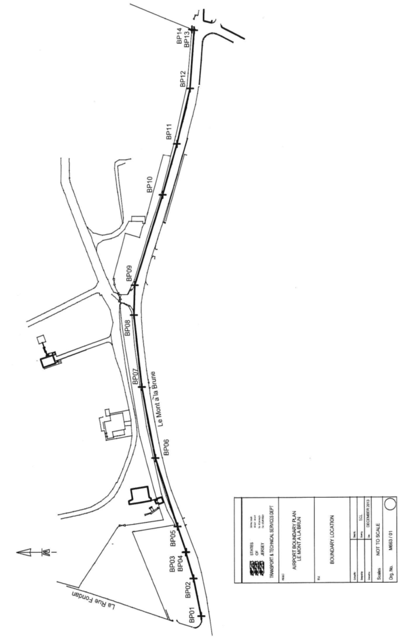
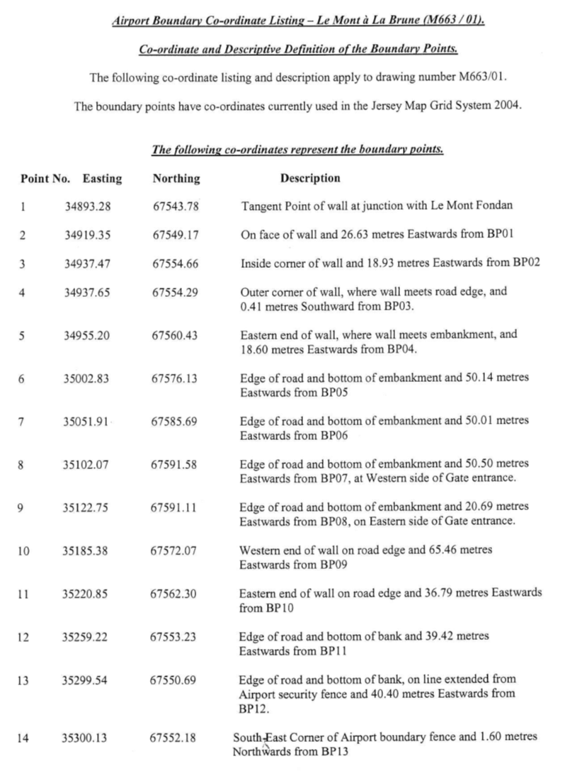
(3) The
boundaries of the Airport –
(a) towards
the Grande Route called “Le Mont à la Brune” are constituted
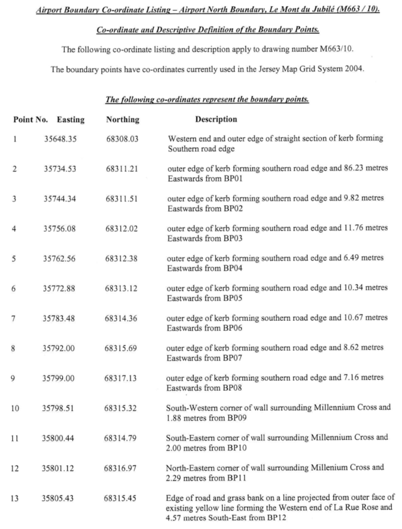
by the lines drawn between and joining the co-ordinate points numbered BP01 to BP14
inclusive
and an imaginary line extended from BP01 in a Westerly direction
towards the Parish by-road “Le Mont Fondan” until reaching the
western extent of the Airport;
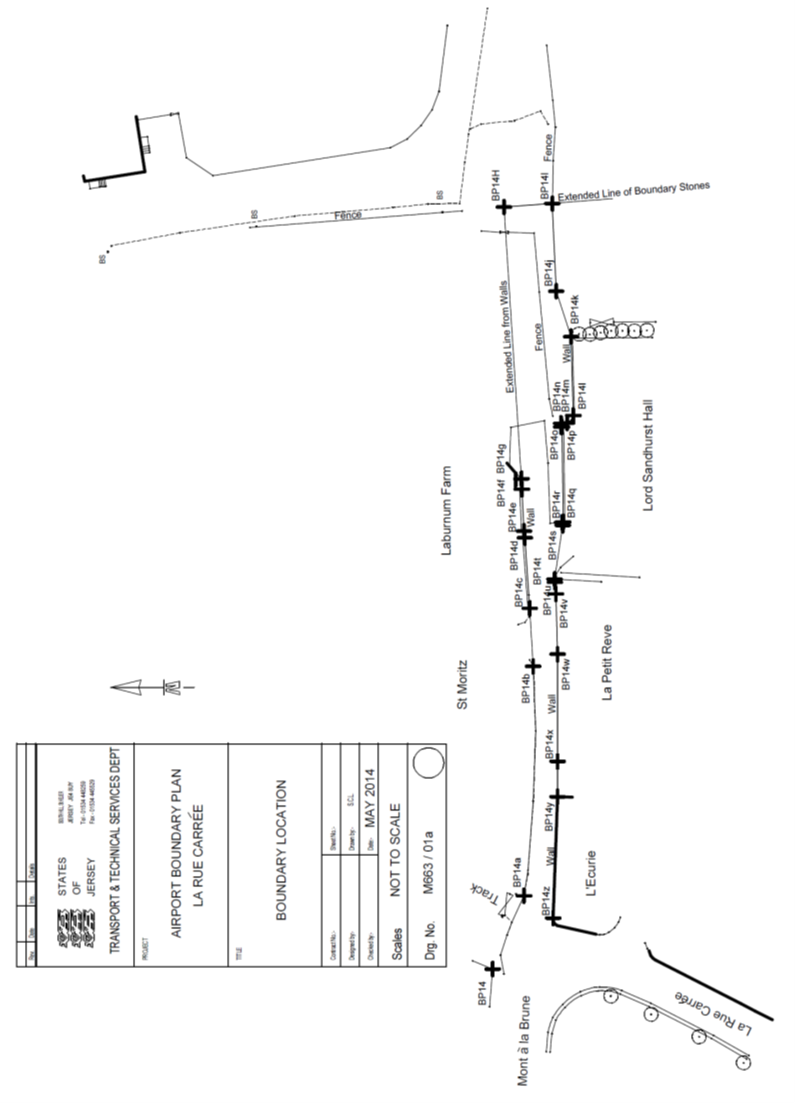
(b) towards
the remainder of the parish by-road called “La Rue Carrée”
(where relevant and necessary) are constituted by the lines drawn between and
joining the co-ordinate points numbered BP14 to BP14z
inclusive;
(c) towards
the Grande Route called “La Rue Carrée” are constituted by
the lines drawn between and joining the co-ordinate points numbered BP15
to
BP26 inclusive;
(d) towards
(i) part of a cycle track owned by the Public co-extensive with the Grande
Route “L’Avenue de la Commune” and (ii) the remainder of
“L’Avenue de la Commune” (as the case may be) are constituted
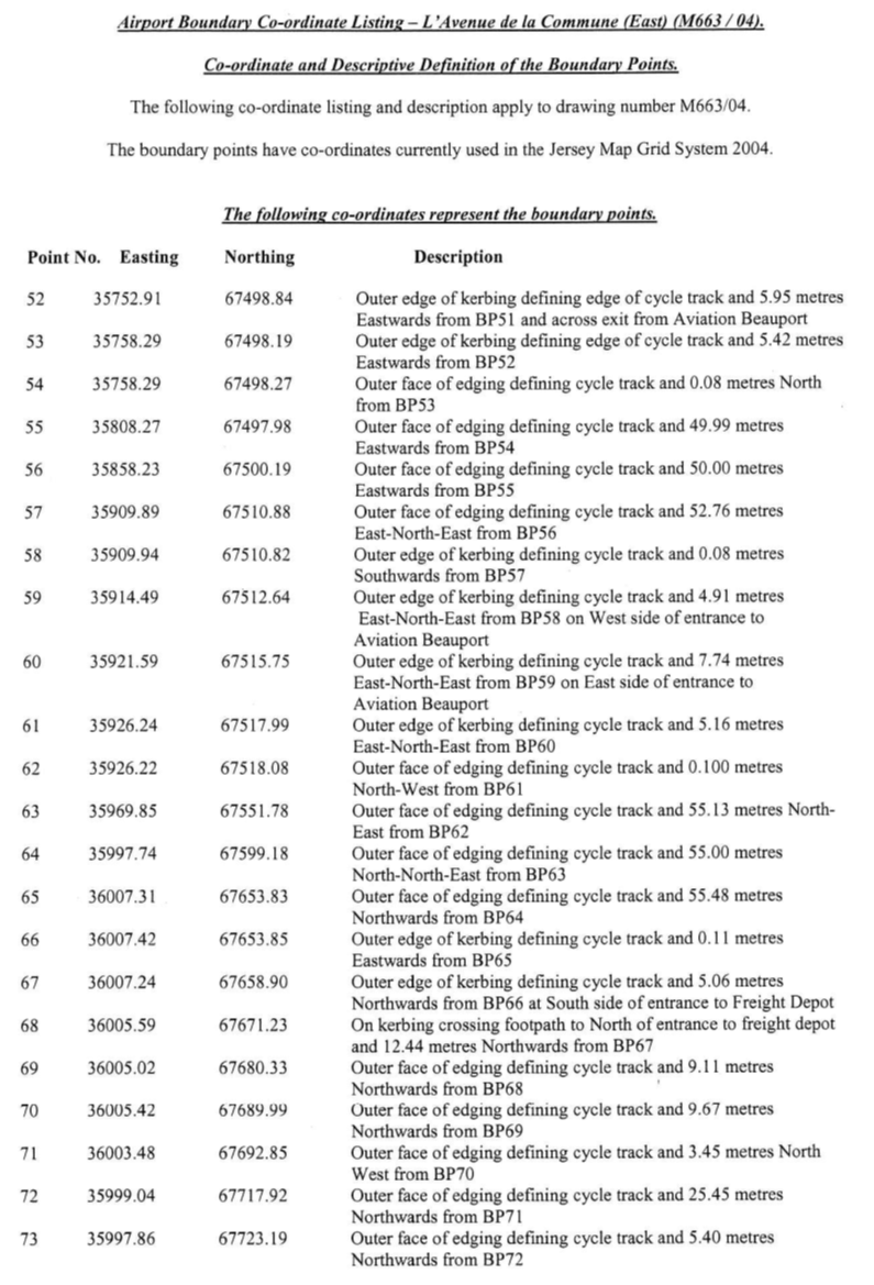
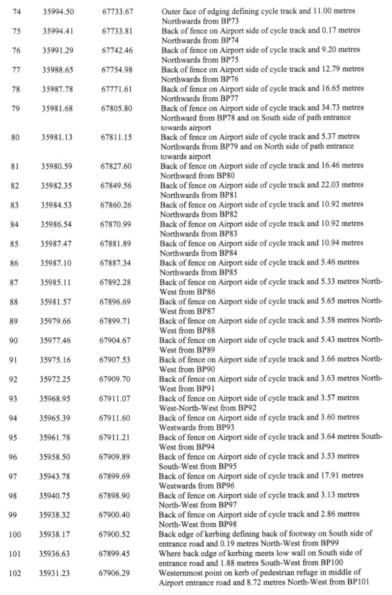
by the lines drawn between and joining the co-ordinate points numbered BP26 to BP86 inclusive;
(e) towards
(i) part of a cycle track owned by the Public co-extensive with the Grande
Route “L’Avenue de la Reine Elizabeth II” and (ii) the
remainder of “L’Avenue de la Reine Elizabeth II” (as the
case may be) are constituted by the lines drawn and joining between the
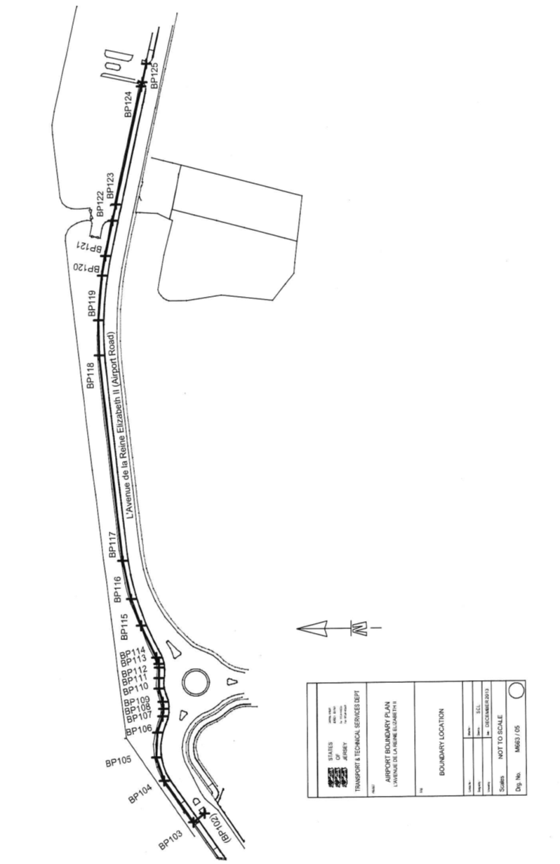
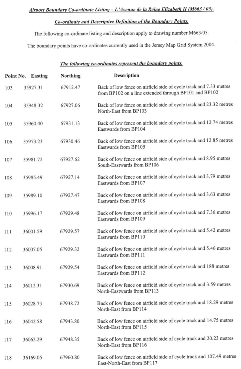
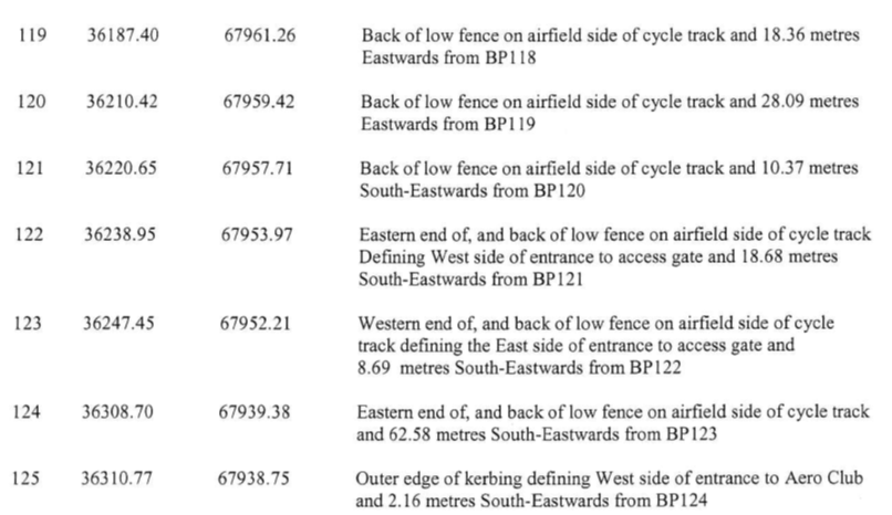
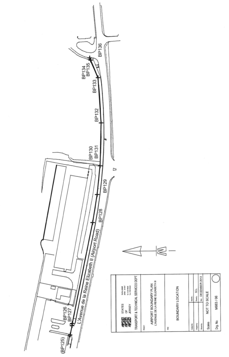
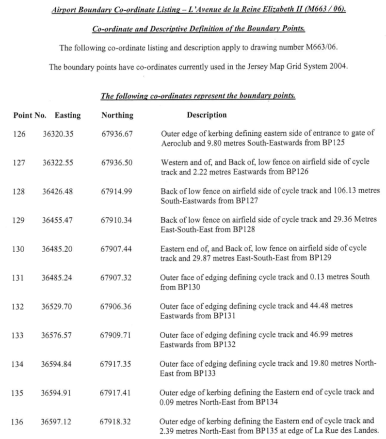
co-ordinate points numbered BP86 to BP136 inclusive;
(f) towards
the Grande Route “La Rue des Landes” are constituted by the lines
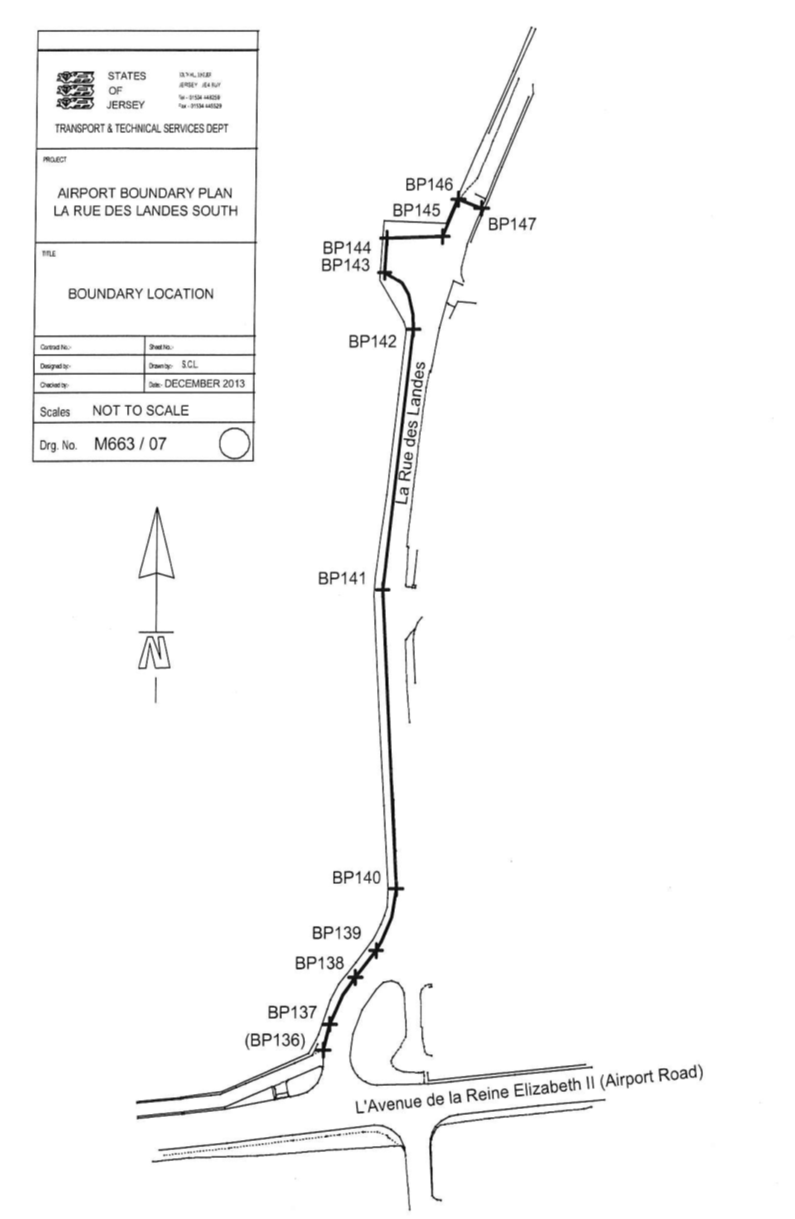
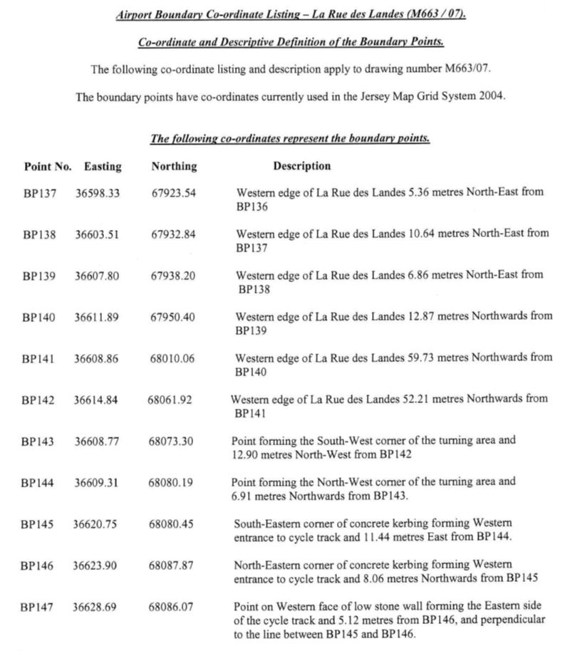
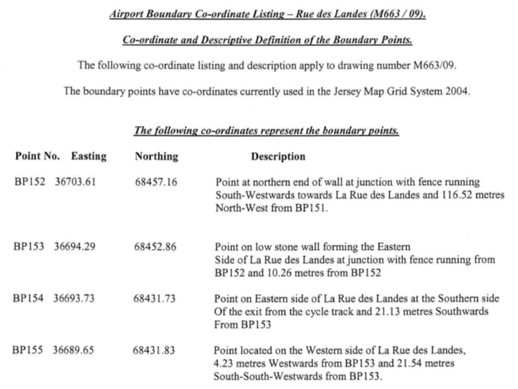
drawn between and joining the co-ordinate points numbered BP136 to BP147 inclusive;
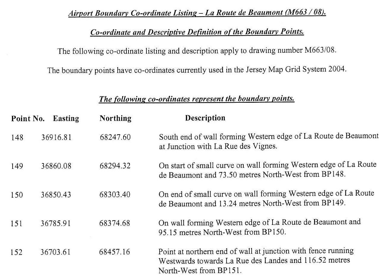
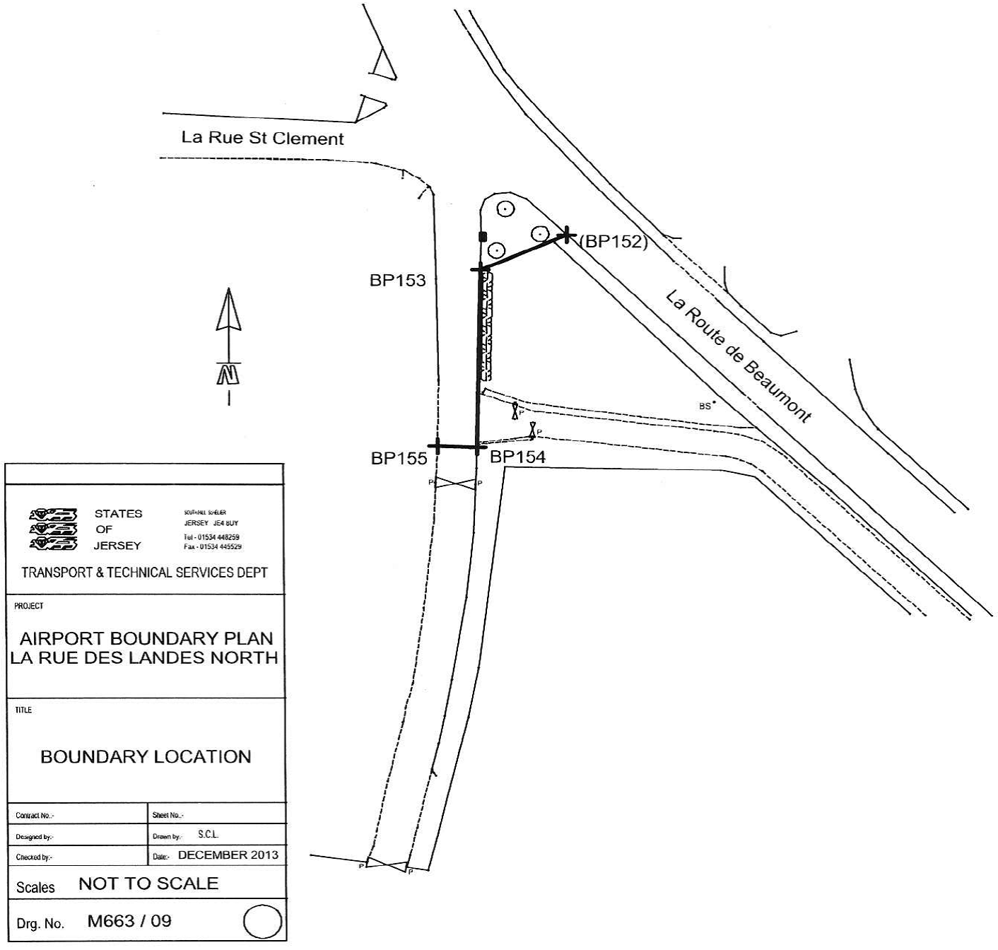
(g) towards
the Grande Route “La Route de Beaumont” are constituted by the
lines drawn between and joining the co-ordinate points numbered BP148 to BP155 inclusive;
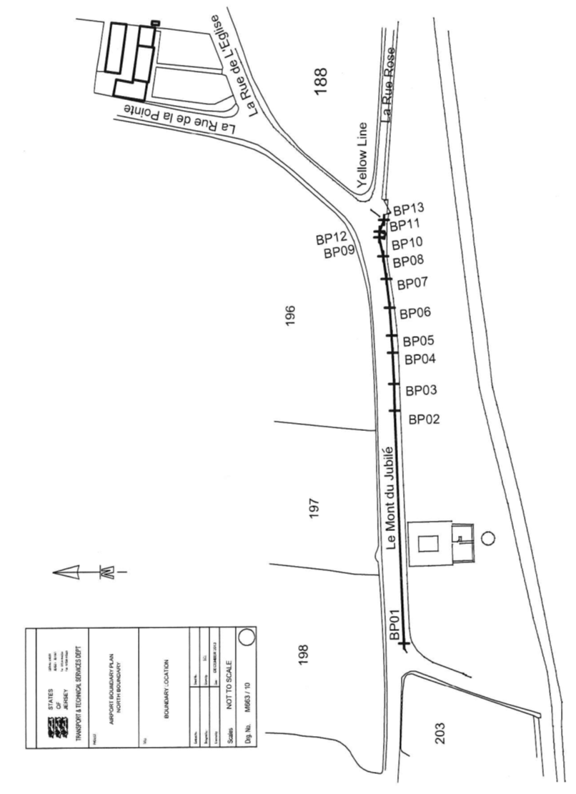
(h) towards
the Grande Route “Le Mont du Jubilé” are constituted by the
lines drawn between and joining the co-ordinate points numbered BP01 to BP09 inclusive and BP12 to BP13
and an imaginary line extended
from BP01 in a westerly direction until reaching the western extent of the
Airport; and
(i) towards
the “Millennium Cross” (belonging to the Parish of St. Peter
and situate to the South or thereabouts of “Le Mont du
Jubilé”) are constituted by the lines drawn between and joining
the co-ordinate points numbered BP09 to BP12 inclusive.
(4) The
Airport is transferred with the benefit and burden of the following rights –
(a) the
section of road situate to the South-East or thereabouts of the line drawn
between and joining BP42 and BP43 forms part of the Grande
Route “L’Avenue de la Commune”;
(b) the
sections of road situate to the South or thereabouts of a line drawn between
and joining (i) BP51 and BP52; (ii) BP59 and BP60 and (iii) BP67 and BP68 form part of the Grande
Route “L’Avenue de la Commune”;
(c) the
section of road situate to the South or thereabouts of a line drawn between BP125 and BP126 forms part of the Grande
Route “L’Avenue de la Reine Elizabeth II”;
(d) the
wooden post and rail fencing found between BP35 and BP42
and BP43
and BP50
shall be
removed by no later than 5 years from the transfer date;
(e) POJL
shall have a right of way and passage in the event of an emergency only from
the Emergency Gate found established near BP122 and BP123 across the cycle track
owned by the Public and this in order to come and go from the Airport to the
Grande Route “L’Avenue de la Reine Elizabeth II”;
(f) the
Public administers and maintains as public sewers both the foul and surface
water sewers laid on in through or beneath the Airport and being –
(i) a public foul
trunk sewer that enters the Airport through the development called
“La Retraite” near the Northern boundary and to the South of
the property called “Tree Tops” from where it heads in a
Southerly direction or thereabouts to a point just North of Runway 26/08
East with a branch foul sewer (described at (ii) below) joining the trunk sewer
at this point and continuing in a Southerly direction beneath the Eastern end
of the Runway to a point approximately midway between the Runway and the Alpha
Taxiway before continuing South-West (to a point a little to the North of the
Alpha Taxiway) and then South (passing beneath the car park forming part of the
premises called “The Jersey Aero Cub”) where it again turns to the
South-West before exiting the Airport beneath “L’Avenue de la Reine
Elizabeth II” (and at each of the changes of direction above
mentioned access chambers have been constructed to the surface of the soil all
of which form part of the public foul trunk sewer),
(ii) the
aforementioned branch foul sewer to the main trunk sewer as described above
which extends in a North-Westerly direction from the said trunk sewer (from a
point to the North of the Runway 26/08 East) running parallel with but to the
South-West of the premises called “Sous l’Eglise” (now
demolished) and the Field numbered 868 on the Jersey Digital Map before
entering into the parish public highway “La Route de
l’Hermite” (access chambers having been constructed to the surface
of the soil which form part of the branch foul sewer),
(iii) two
surface water trunk sewers (lying to the East of the trunk foul sewers detailed
above) which enter the Airport (from separate directions) beneath its Northern
boundary the first sewer entering from the North beneath a private access
situate between the properties “Tree Tops” and “Green Banks”
and the second sewer entering beneath the southern edge of the Field
numbered 650 on the Jersey Digital Map and the said property “Green
Banks” before connecting to the first sewer above mentioned the combined
surface water trunk sewer then extends to the South beneath the Eastern limit
of Runway 26/08 to a point a little to the north of the Alpha Taxiway and then
extended towards the South-West crossing beneath both the Alpha Taxiway and the
said car park forming part of the “Jersey Aero Club” before exiting
the Airport beneath “L’Avenue de la Reine Elizabeth II”
and thereafter discharging into the large water impounding area (on the South
side of the said main road) in the Fields numbered 787 and 788 on the Jersey
Digital Map (access chambers having been constructed to the surface of the soil
each of which form part of the branch surface water sewer),
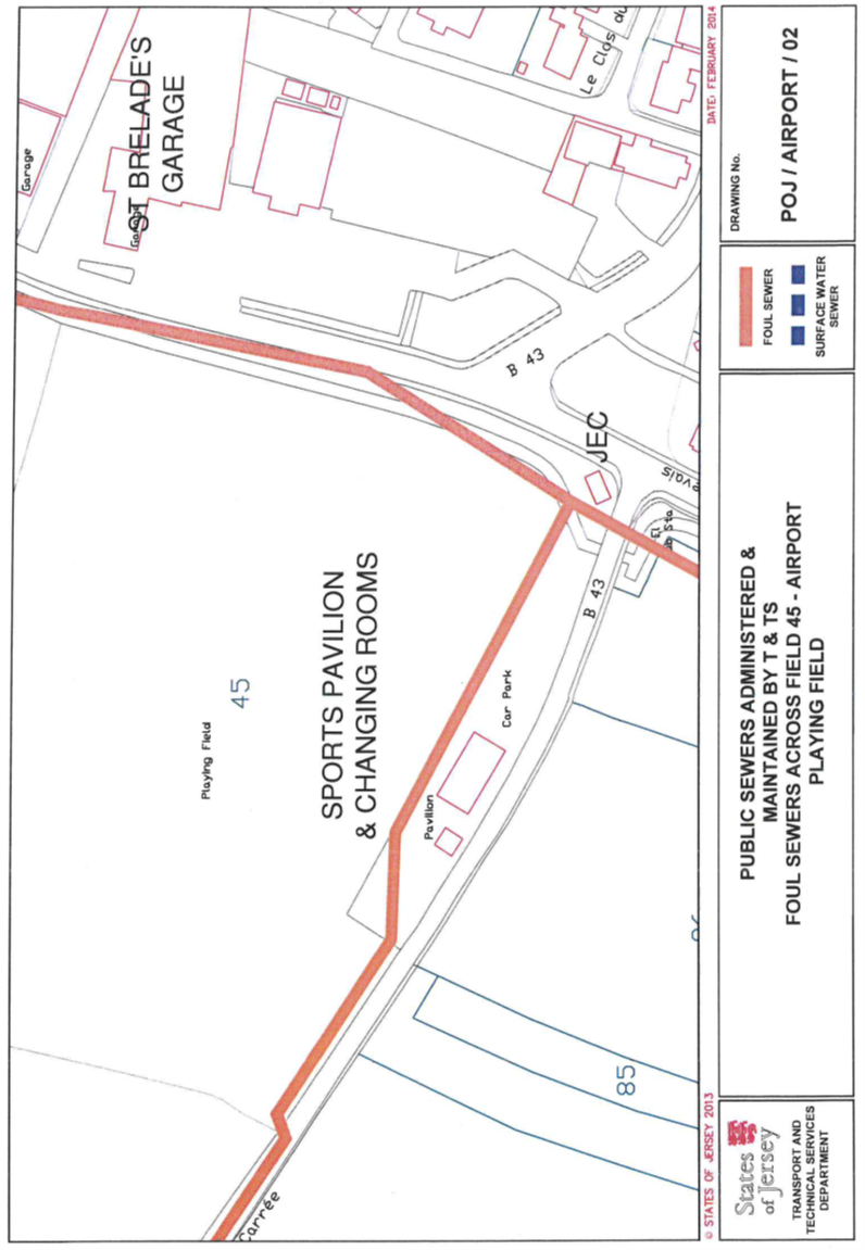
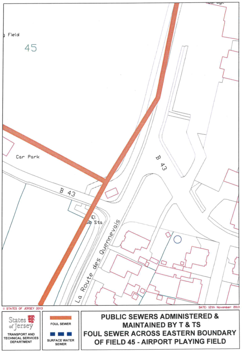
(iv) two
foul pumped sewers which enter (and lie beneath) the Field numbered 45 on
the Jersey Digital Map (“Field 45”) at its South-West corner
and extend in a North-West to South-East direction before diverting around the
Northern side of a building being a Sports Pavilion and Changing Room and
thence extending to connect with the public foul sewer near the South-Eastern
corner of Field 45 and found beneath a cycle track belonging to the
Public,
(v) a foul sewer which
enters (and lies beneath) Field 45 at its South-Eastern corner and extends
in an approximate North-Easterly direction until a point where it is to be
found beneath the said cycle track;
(g) for
the avoidance of doubt the Public does not maintain or administer any branch
connections from the aforementioned public sewers to any part of the Airport or
any road drainage system in the roads forming part of the Airport;
(h) the
Public (which expression includes, for the avoidance of doubt in this context,
all and any individual members of the general public) shall have a right of way
at all times and for all purposes both on foot and by pedal cycle along the
cycle track and footpath situate along the eastern side or thereabouts of the
Airport and this to come and go from the southern part of the Grande Route
“La Rue des Landes” to the northern part of “La Rue des
Landes” and this without any obligation on the part of the Public to
contribute in any manner whatever to the costs of maintenance repair resurfacing
and replacement thereof, and POJL shall always keep maintain repair and replace
the cycle track and footpath in a good and proper condition so that the Public
may exercise their rights of way without let or hindrance;
(i) Field 45,
as shown for the purposes of this clause on the Plan marked AIP001(a) by
cross-hatched lines, shall be used only for recreation and for no other
purpose;
(j) POJL
shall be subject to the terms and conditions contained in the 16 contracts
entered into by the Public and immediately hereafter set out –
|
Date
|
Reference
|
|
27th
July 1935
|
(PR
426/166)
|
|
6th
December 1974
|
(PR
632/88)
|
|
4th
March 1977
|
(PR
666/38)
|
|
29th
January 1982
|
(PR
738/622)
|
|
7th
June 1985
|
(PR
796/58)
|
|
20th
December 1991
|
(PR
911/277)
|
|
21st
February 1992
|
(PR
913/524)
|
|
4th
March 1994
|
(PR
960/1)
|
|
26th
September 1997
|
(PR
1039/182)
|
|
27th
July 2001
|
(PR
1122/129)
|
|
22nd
March 2002
|
(PR
1134/477)
|
|
10th
October 2003
|
(PR
1160/947)
|
|
19th
December 2003
|
(PR
1164/274
|
|
27th
June 2008
|
(PR
1237/934)
|
|
13th
February 2009
|
(PR
1246/300)
|
|
11th
March 2011
|
(PR
1274/962
|
(k) POJL
shall be subject to the terms and conditions contained in the following 8 contracts
of lease and sub-lease and any variations thereof entered into by the Public
with the following parties and passed before the Royal Court (refer thereto) –
|
Date
|
Reference
|
Name
|
|
14th June 1996
|
(PR 1012/431)
|
“Aviation Beauport (Hangar
Services) Limited”
|
|
22nd November 1996
|
(PR 1022/339)
|
“Interlock Investments
Limited”
|
|
19th September 1997
|
(PR 1038/346)
|
“Spellbound Holdings
Limited”
|
|
31st July 1998
|
(PR 1057/306)
|
“Aviation Beauport (Hangar
Services) Limited”
|
|
8th June 2001
|
(PR 1119/386)
|
“Jersey Aero Club”
|
|
4th
November 2005
|
(PR
1192/32)
|
“Hallmark
Cars Limited”
|
|
3rd
October 2008
|
(PR
1242/209)
|
“The
Jersey Electricity Company Limited”
|
|
22nd
May 2009
|
(PR
1250/309)
|
“Jersey
Aviators Limited”.
|

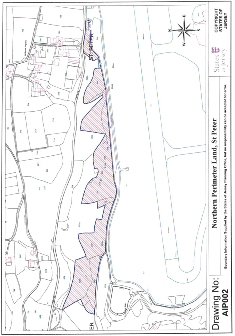
2 Northern Perimeter Land,
Jersey Airport, St. Peter
(1) The
property (the “Northern Perimeter Land”) situate in the Grande
Vingtaine in the Parish of St. Peter and comprising a piece of land
forming part of the Northern perimeter of Jersey Airport as shown on the plan
marked AIP002.
(2) The
Public is entitled to the Northern Perimeter Land –
(a) partly
by the following 15 contracts of acquisition –
|
Date
|
Reference
|
|
4th May 1949
|
(PR 450B/158)
|
|
21st May 1949
|
(PR 450C/184)
|
|
4th June 1949
|
(PR 450A/212)
|
|
18th June 1949
|
(PR 450A/226)
|
|
24th September 1949
|
(PR 449B/236)
|
|
24th September 1949
|
(PR 451C/78)
|
|
1st October 1949
|
(PR 451B/76)
|
|
8th October 1949
|
(PR 451B/85)
|
|
8th October 1949
|
(PR 451B/86)
|
|
22nd October 1949
|
(PR 451C/116)
|
|
5th November 1949
|
(PR 451A/131)
|
|
10th December 1949
|
(PR 451C/216)
|
|
17th December 1949
|
(PR 451A/234)
|
|
28th January 1950
|
(PR 451B/280)
|
|
28th June 1991
|
(PR 902/49);
|
(b) partly
by a contract (of exchange and counter-exchange) dated 26th September 1997
with the Parish of St. Peter (PR1039/182); and
(c) as to
the remainder by peaceable undisturbed title and possession of in excess of
40 years (“possession
quadragenaire”) “nec vi, nec clam, nec precario”.
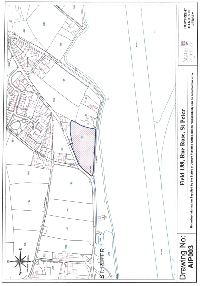
3 Field 188, La Rue de
l’Eglise, St. Peter
(1) The
property (“Field 188”) having the UPRN 69216319 and situate in
the Vingtaine du Douet in the Parish of St. Peter and
comprising –
(a) a
piece of land broadly triangular in shape being formerly the site of the house
“Balmoral” and its appurtenances (all now demolished); and
(b) the
field known as “Le Clos de Croix”,
as shown on the plan
marked AIP003.
(2) The
Public is entitled to Field 188 by contract of acquisition dated 21st
May 1949 (PR450c/186).
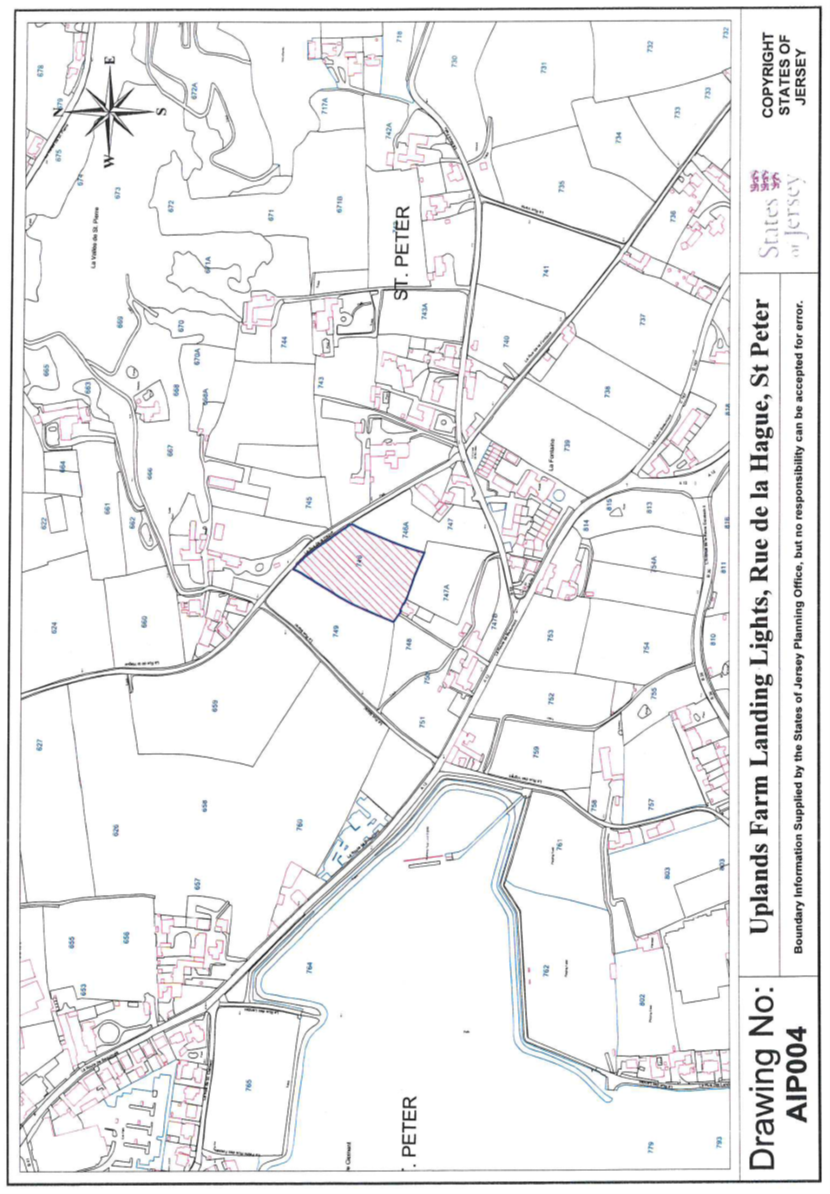
4 Uplands Farm Landing
Lights, Field 746, La Rue de la Hague, St. Peter
(1) The
property (“Field 746”) having the UPRN 69216842 and situate in
the Vingtaine de St. Nicolas in the Parish of St. Peter and
comprising –
(a) a
piece of land known as “Le Clos de Bechervaise”, situate on La Rue
de la Hague and numbered 746 on the Jersey Digital Map and having
previously formed part of the property “Uplands”; together with
(b) the
Versatower triangular approach lighting pylons to Runway 026/8 at Jersey
Airport located on the land described in clause (a),
as shown on the plan
marked AIP004.
(2) The
Public is entitled to Field 746 by contract of acquisition dated 22nd
June 2012 (PR1297/517).
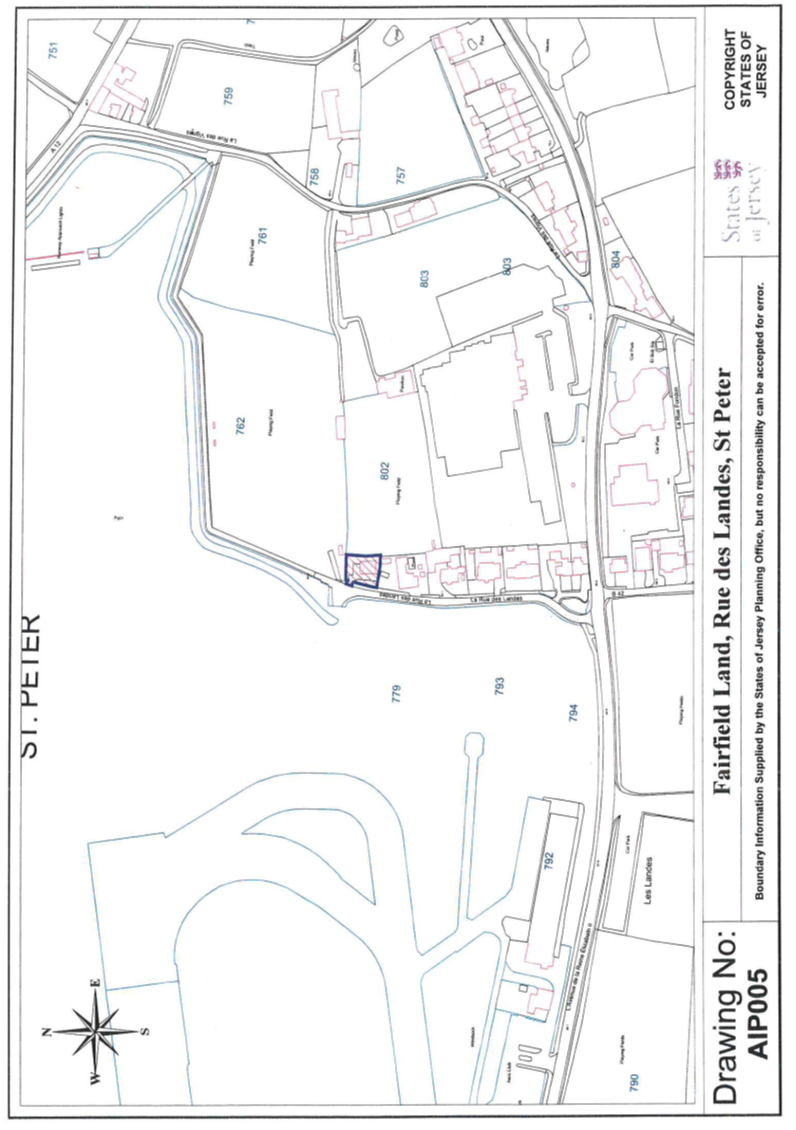
5 Fairfield, La Rue des
Landes, St. Peter
(1) The
Property (“Fairfield”) having the UPRN 69118601 and situate in the
Vingtaine du Douet in the Parish of St. Peter and comprising the site of a
house and its appurtenances known as “Fairfield” (all now
demolished), as shown on the Plan marked AIP005.
(2) The
Public is entitled to Fairfield by contract of acquisition dated
22nd March 2002 (PR1134/477).
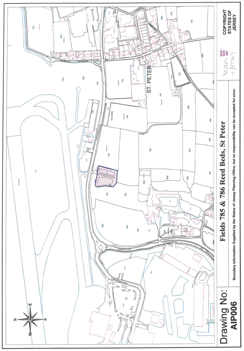
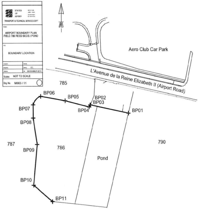
6 Reed Beds, (Fields 785
& 786), L’Avenue de la Reine Elizabeth II, St. Peter
(1) The
property (the “Reed Beds”) having the UPRN’s 69216393 and
69216394 and situate in the Vingtaine du Douet in the Parish of St. Peter
and comprising –
(a) 2 pieces
of land numbered 785 and 786 on the Jersey Digital Map; together with
(b) certain
filtration reed beds with their associated drainage apparatus and
appurtenances,
as shown on the Plan
marked AIP006 and with the boundaries further
described in sub-paragraph (3).
(2) The
Public is entitled to the Reed Beds by contract of acquisition dated
24th September 1976 (PR659/119).
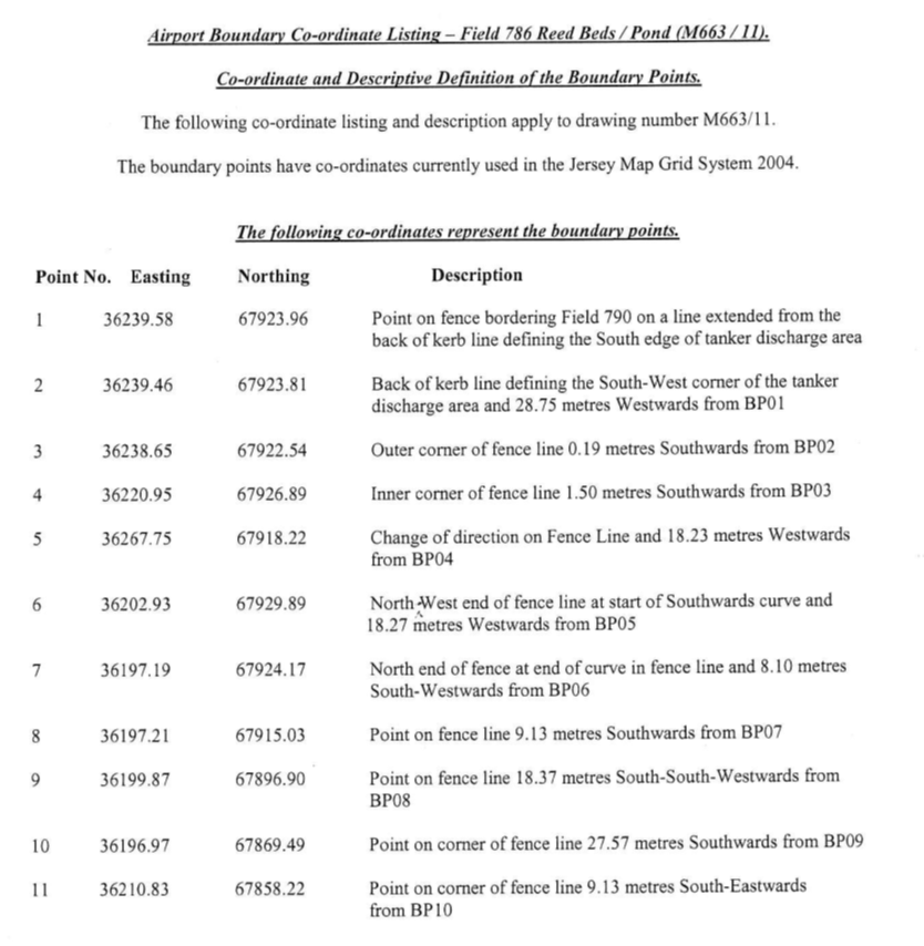
(3) The
boundaries of the Reed Beds –
(a) towards
the land owned by the Public are constituted by the lines drawn between and
joining the co-ordinate points numbered BP01 to BP11
inclusive (as set out on the Co-Ordinate Point Plan dated December 2013
and as listed in the Co-Ordinate Point Listing both marked M663/11) and
extended (i) in an easterly direction from BP01
(following the same alignment as the line connecting BP02 to BP01) and
(ii) in an easterly direction from BP11 (parallel with the line joining BP02 to BP01) until
reaching the eastern limit of the Reed Beds; and
(b) are
otherwise contained in a contract of sale by the Public to Jersey Rugby
Football Club Limited dated 17th October 2003 (PR1161/121).
(4) The
Reed Beds are transferred with the benefit of the following rights –
(a) all
walls fences hedges or other enclosures on or near any of the boundaries of the
Reed Beds belong (without relief) to POJL and may remain as they are
established on the transfer date;
(b) any
parts of such walls fences hedges or other enclosures which may overhang or
otherwise encroach on any part of the property owned by the Public may remain
as they are established on the transfer date;
(c) POJL
shall have a right of way and passage at all times and for all purposes through
the entrance owned by the Public to the North of the Reed Beds in order to come
and go from the Reed Beds to the Grande Route “L’Avenue de la Reine
Elizabeth II”;
(d) POJL
has the right to drain the waters which discharge from the Reed Beds onto and
through the land belonging to the Public in the vicinity.
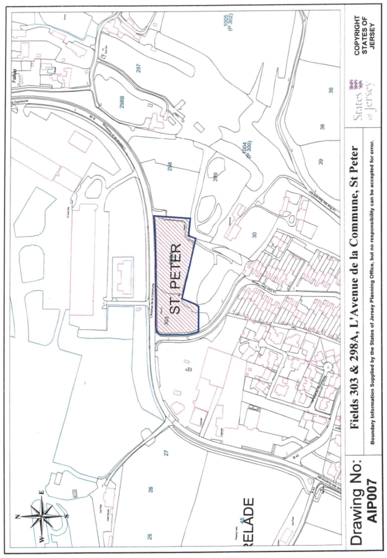
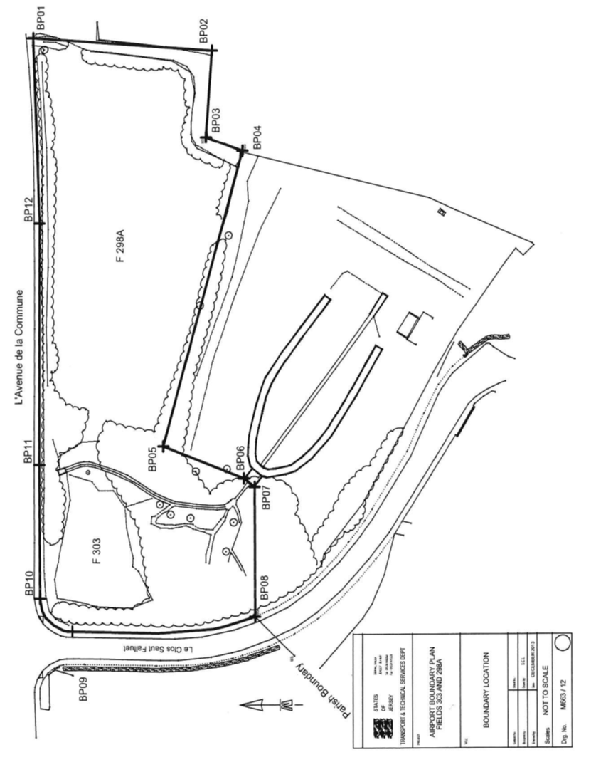
7 Saut Falluet Land (Fields
303 & 298a), L’Avenue de la Commune, St. Peter and
St. Brelade
(1) The
property (the “Saut Falluet Land”) having the UPRNs 69216394 and
69216430 and situate partly in the Grande Vingtaine in the Parish of
St. Peter and the remainder in the Vingtaine des Quennevais in the Parish
of St. Brelade and comprising –
(a) a
piece of land bearing the number 303 (“Field 303”) on the
Jersey Digital Map; together with
(b) a
piece of land adjoining Field 303 to the East and bearing the
number 298A (“Field 298A”) on the Jersey Digital Map,
as shown on the plan
marked AIP007 and with the boundaries described
in paragraph 3.
(2) The
Public is entitled to the Saut Falluet Land –
(a) partly
by contract of acquisition dated 18th June 1949 (PR450A/228);
and
(b) as to
the remainder by a contract of purchase dated 7th November 1975
(PR645/252).
(3) The
boundaries of the Saut Falluet Land –
(a) towards
the Grande Route “L’Avenue de la Commune”;
(b) towards
part of a road owned by the Public and connecting “L’Avenue de la
Commune” with “Le Clos Saut Falluet”; and
(c) towards
the land owned by the Public and bearing the number 298 on the Jersey
Digital Map,
are constituted by the
lines drawn between and joining the co-ordinate points numbered BP01 to BP12
inclusive and by a line extended from BP01 in a
Northerly direction until reaching the Southern limit of “L’Avenue
de la Commune” as set out on the Co-Ordinate Point Plan dated
December 2013 and as listed in the Co-Ordinate Point Listing both marked M663/12.
(4) The
Saut Falluet Land is transferred with the benefit of the following
rights –
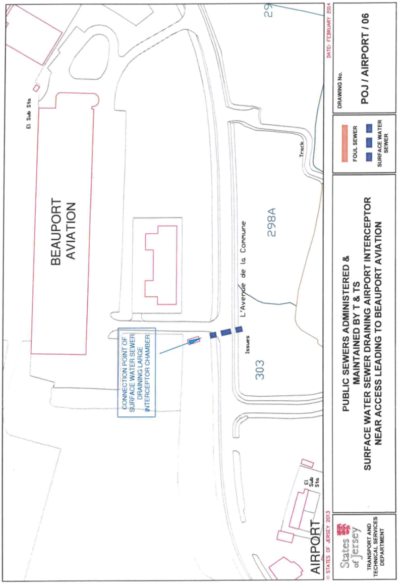
(a) the
Public shall maintain as public sewers –
(i) the public
surface water sewer entering the Saut Falluet Land on its western side or
thereabouts and extending in a south-easterly direction until exiting the Saut
Falluet Land near its south-eastern corner as shown on the annexed Plan
POJ/AIRPORT/05 dated February 2014, and
(ii) the
public surface water sewer entering the Saut Falluet Land on its northern side
or thereabouts and extending in a southerly direction until exiting the Saut
Falluet Land near its south-eastern corner as shown on the annexed Plan POJ/AIRPORT/06
dated February 2014;
(b) POJL
shall have a right of way and passage at all times and for all purposes through
the entrance owned by the Public to the North of and forming part of
Field 298 in order to come and go from the Saut Falluet Land to
“L’Avenue de la Commune”.
(5) The
Saut Falluet Land is transferred subject to the reservation of a right of way
and passage for the Public at all times and for all purposes along the Eastern
side of the Saut Falluet Land in order to come and go from the land owned by
the Public to the South or thereabouts of the Saut Falluet Land to
“L’Avenue de la Commune”.
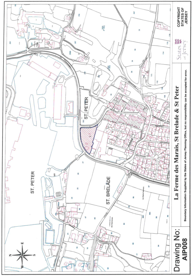
8 La Ferme des Marais,
L’Avenue de la Commune, St. Peter and St. Brelade
(1) The
property (“La Ferme des Marais”) having the UPRN 69200831 and
situate partly in the Grande Vingtaine in the Parish of St. Peter and the
remainder in the Vingtaine de Quennevais in the Parish of St. Brelade and
comprising –
(a) premises
comprising buildings, fuel pumps, asphalt garage forecourt, tarmacadam and concrete
covered land and all other appurtenances and dependancies situate to the South
or thereabouts of the Grande Route “L’Avenue de la Commune”;
and
(b) the
soil (“fonds”) of a roadway situate to the South or thereabouts and
co-extensive with the premises described in clause (a),
as shown marked on the
Plan AIP008 and with the boundaries described
in sub-paragraph (3).
(2) The
Public is entitled to La Ferme des Marais –
(a) partly
by contract of acquisition dated 18th June 1949 (PR450A/228);
(b) partly
by contract of purchase dated 7th November 1975 (PR645/252); and
(c) as to
the remainder by peaceable undisturbed title and possession of in excess of
40 years (“possession
quadragenaire”) “nec vi, nec clam, nec precario”.
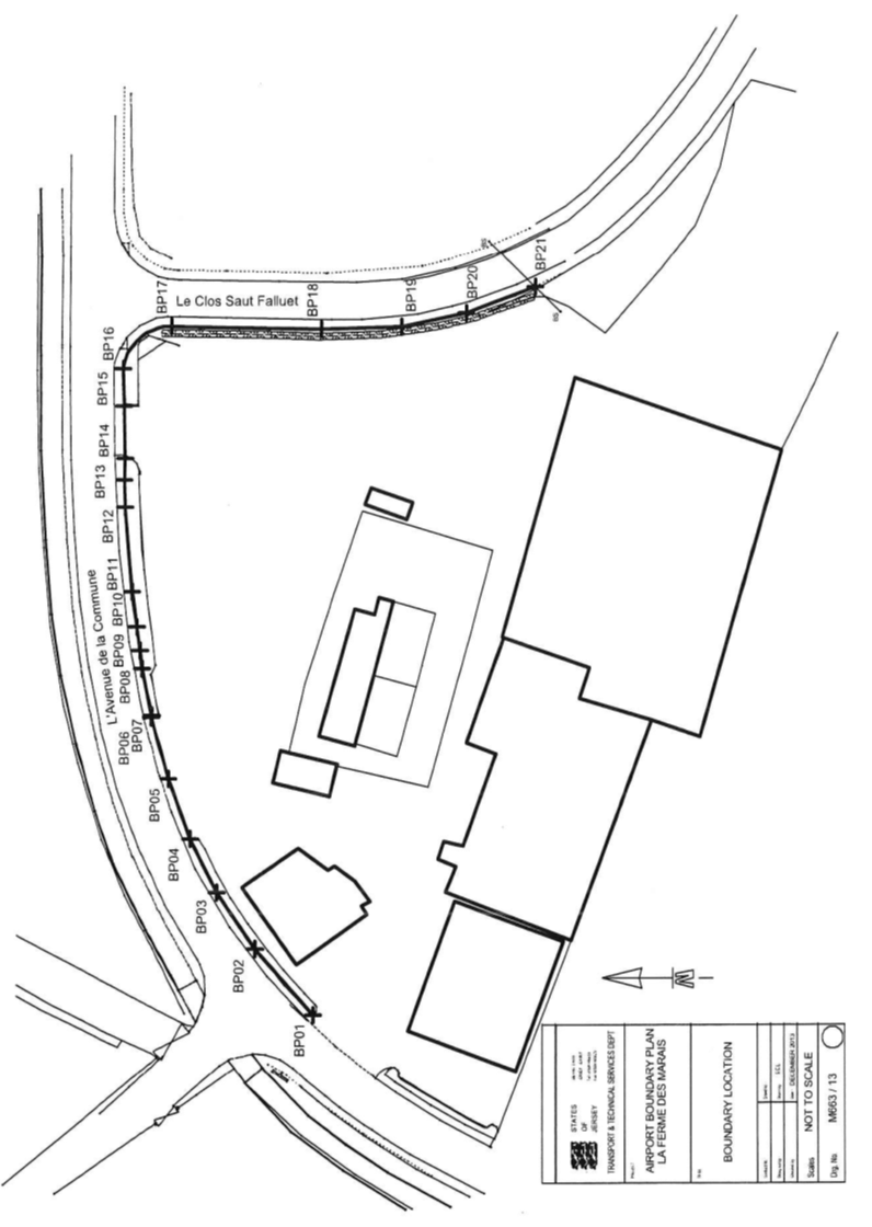
(3) The
boundaries of La Ferme des Marais towards “L’Avenue de la
Commune” and towards part of a road owned by the Public connecting
“L’Avenue de la Commune” with “Le Clos Saut
Falluet” are constituted by the lines drawn between and joining the
co-ordinate points numbered BP01 to BP21 inclusive and extended –
(a) from BP01 in a
South-Westerly direction or thereabouts until reaching the South-Western corner
of La Ferme des Marais; and
(b) from BP21 in a
Southerly direction or thereabouts until reaching the South-Eastern corner of
La Ferme des Marais,
as set out on the
Co-Ordinate Point Plan dated December 2013 and as listed in the
Co-Ordinate Point Listing, both marked M663/13.
(4) La
Ferme des Marais is transferred subject to the following rights –
(a) the
Public shall maintain as a public sewer the surface water sewer entering La
Ferme des Marais on its North-Western side or thereabouts and extending in a
South-Easterly direction until exiting La Ferme des Marais on its eastern side
as shown on the annexed Plan dated 29th November 2013 and marked
POJ/AIRPORT/05;
(b) POJL
shall be subject to the terms and conditions contained in a contract of lease
dated 22nd November 1996 between the Public and “Interlock
Investments Limited” and another (PR1022/339).
9 Old
Fuel Farm Site, L’Avenue de la Commune, St. Brelade
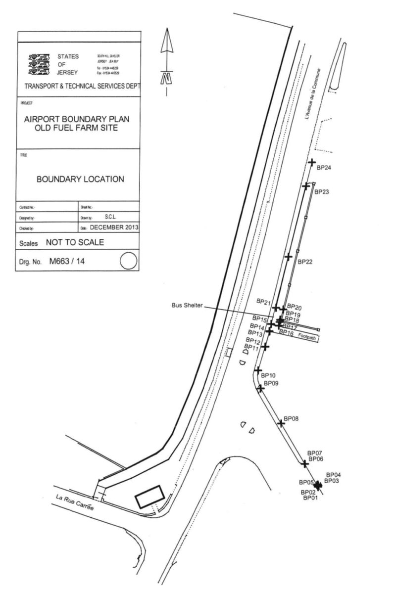
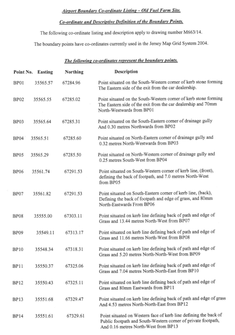
(1) The
property (the “Old Fuel Farm Site”) having the UPRN 69402040
and situate in the Vingtaine de Quennevais in the Parish of St. Brelade
and comprising land with the buildings, garages, asphalt forecourts and other
appurtenances as shown on the Plan marked AIP009
and with the boundaries described in sub-paragraph (3).
(2) The
Public is entitled to the Old Fuel Farm Site by contract of acquisition dated
4th May 1949 (PR450B/158 7th corpus-fundi).
(3) The
boundaries of the Old Fuel Farm Site –
(a) towards –
(i) the Grande Route
“L’Avenue de la Commune”, and
(ii) the
parish by-road “Le Pont du Val”,
are constituted by the
lines drawn between and joining the co-ordinate points numbered BP01 to BP24
inclusive and extended from BP24 in a Northerly direction or thereabouts until reaching the Northern
limit of the Old Fuel Farm Site as set out on the Co-Ordinate Point Plan dated
December 2013 and as listed in the Co-Ordinate Point Listing both marked M663/14; and
(b) are
otherwise contained not only in the contract mentioned in sub-paragraph (2)
but also in a contract of sale of land by the Public
dated 20th August 2010 (PR1266/895).
(4) The
Old Fuel Farm Site is transferred subject to the following rights –
(a) the
Public may place keep maintain and replace all and any signage as it may from
time to time require on the open grass area in the South-West corner of the Old
Fuel Farm Site;
(b) POJL
shall be subject to the terms and conditions contained in a contract of lease
dated 19th September 1997 between the Public and
“Spellbound Holdings Limited” (PR1038/346).
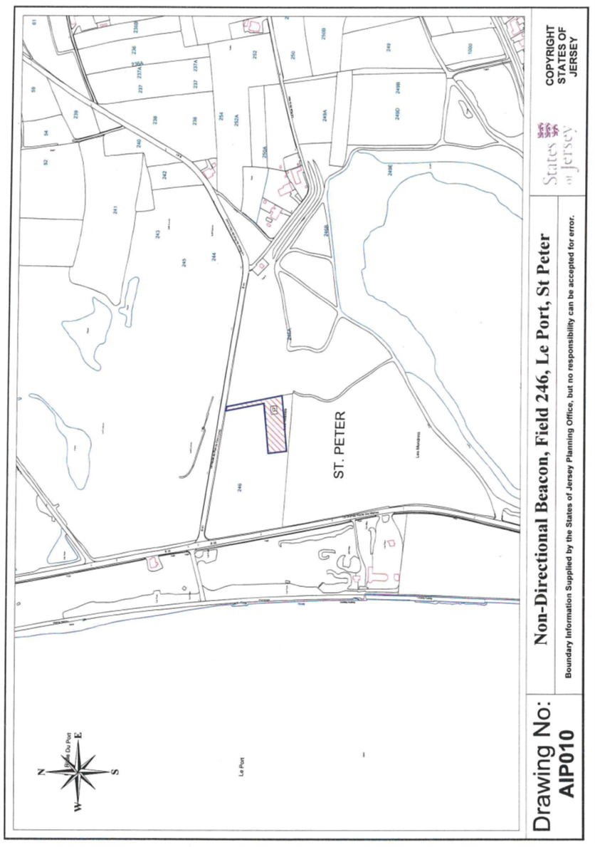
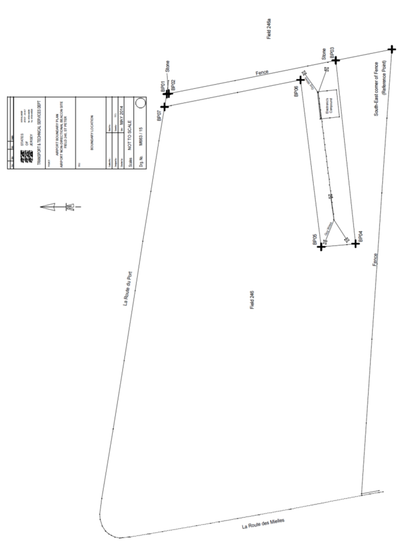
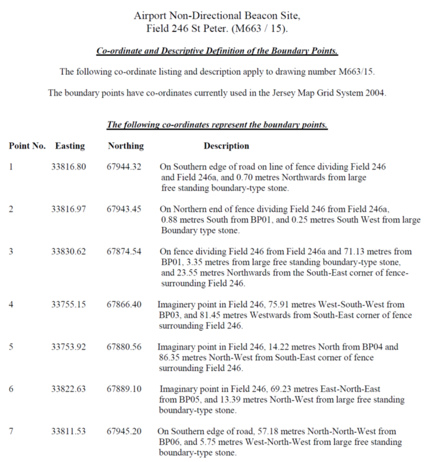
10 Airport Non-Directional Beacon, Part
of Field 246, La Grande Route des Mielles, St. Peter
(1) Part
of the property (the “Non-Directional Beacon Site”) having the
UPRN 69201037 and situate in the Grande Vingtaine in the Parish of
St. Peter Company and comprising –
(a) part
of a piece of land or dune (mielle) situate in the Eastern part of the field numbered 246 on the
Jersey Digital Map at Le Port; together with
(b) the
“Airport Non-Directional Beacon” and associated apparatus on the
land as shown on the plan marked AIP010 and with the boundaries
described in sub-paragraph (3).
(2) The
Public is entitled to the whole of Field 246 by contract of acquisition
dated 28th November 1969 (PR562/180, 2nd corpus-fundi).
(3) The
boundaries of the Non-Directional Beacon Site towards the remainder of
Field 246 belonging to the Public are constituted by the lines drawn
between and joining the co-ordinate points numbered BP01
to BP07 inclusive as set out on the Co-Ordinate
Point Plan dated May 2014 and as listed in the Co-Ordinate Point Listing
both marked M663/15.
(4) The
Non-Directional Beacon Site is transferred subject to the requirement that the
Public shall maintain and use its land adjacent to the Non-Directional Beacon
Site at all times in such manner so as not to interfere with the proper working
of the “Airport Non-Directional Beacon” and associated apparatus.
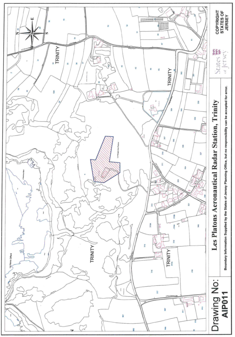
11 Les Platons Aeronautical Radar
Station, La Rue des Platons, Trinity
(1) The
property “Les Platons Aeronautical Radar Station”) having the
UPRN 64905787 and situate at Les Platons in the Vingtaine of
Ville-à-l’Evêque in the Parish of Trinity and
comprising –
(a) a
piece of land of irregular shape at “Les Platons”; together with
(b) the
radiotelegraph mast and associated apparatus on the land,
as shown on the plan
marked AIP011.
(2) The
Public is entitled to Les Platons Aeronautical Radar Station by contract of lease
dated 14th August 1992 (PR923/311).
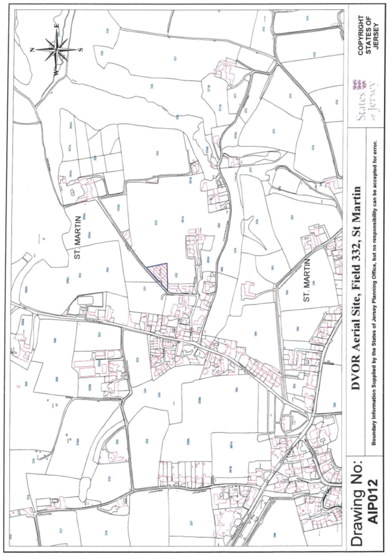
12 DVOR Aerial Site, Field 332, La
Becterie, St. Martin
(1) The
property (“DVOR Aerial Site”) having the UPRN 69301425 and
situate in the Vingtaine of Rozel in the Parish of St. Martin and
comprising –
(a) a piece
of land of triangular shape in the North-East corner of a field known as
“La Carrière” numbered 332 on the Jersey Digital Map
and adjoining the parish road “La Becterie”; together with
(b) the
DVOR Aerial and associated apparatus on the land,
as shown on the Plan
marked AIP012.
(2) The
Public is entitled to the DVOR Aerial Site by contract of acquisition dated
15th May 1981 from (PR728/609).
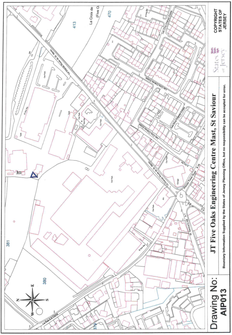
13 JT Five Oaks Engineering Centre Mast,
St. Saviour
All and such rights to
which the Public may be entitled in relation to the Jersey Telecom mast and
such as they are set out in Schedule 2, Regulation 9 of the Telecommunications
(Transfer) (Jersey) Regulations 2002 registered in the Public Registry
by Act of the Royal Court dated 5th July 2005 (PR1186/655).
The “JT Five Oaks
Engineering Centre Mast” as shown on the Plan marked AIP013 and
annexed hereto.
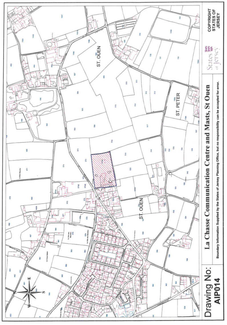
14 La Chasse Communications Centre and
Masts, Le Chemin de L’Eglise, St. Ouen
(1) The
property (“La Chasse Communications Centre and Masts”) having the
UPRN 69380257 and situate in the Petite Cueillette in the Parish of
St. Ouen and comprising –
(a) a
piece of land known as “Le Clos de Pipon” numbered 573A on the
Jersey Digital Map; together with
(b) the
buildings, transmitting masts and appurtenances, and car park on the land,
as shown on the Plan
marked AIP014.
(2) The
Public is entitled to La Chasse Communications Centre and Masts by contract of
acquisition dated 15th November 1947 (PR447B/32).
(3) The
boundaries of the La Chasse Communications Centre and Masts are otherwise
contained not only in the contract mentioned in sub-paragraph (2) but also
in a contract of sale of land by the Public dated 15th June 2007
(PR1220/15).
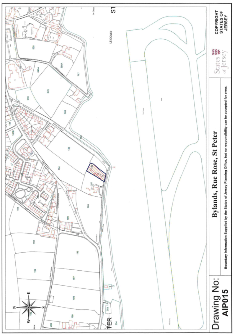
15 Bylands, La Rue
Rose, St. Peter
(1) The
property (“Bylands”) having the UPRN 69120836 and situate in the
Vingtaine du Douet in the Parish of St. Peter and comprising a house
garage outbuildings driveway gardens and their appurtenances as shown on the
plan marked AIP015.
(2) The
Public is entitled to Bylands by contract of acquisition dated 14th November 2014
(PR1341/412).
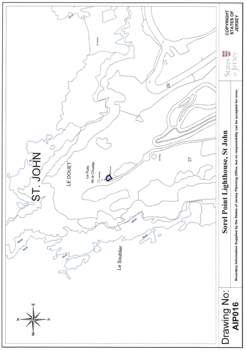
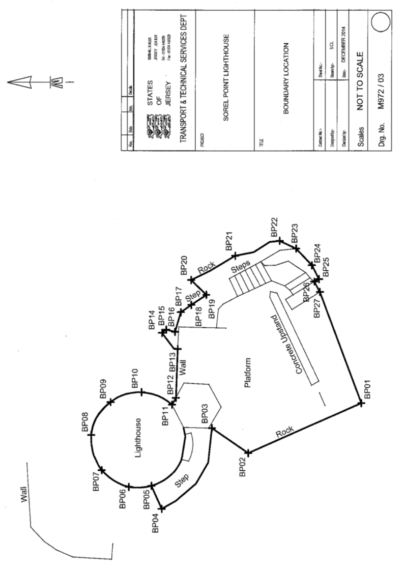
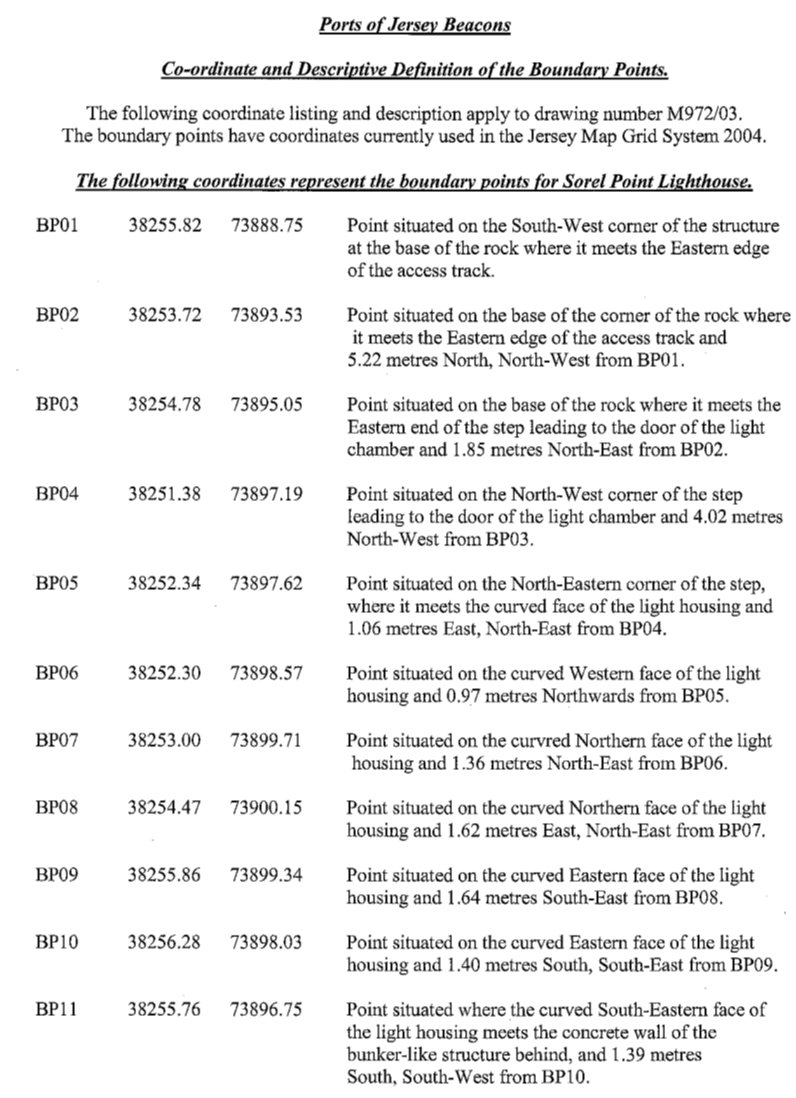
16 Sorel Lighthouse,
La Route du Nord, St. John
(1) The
property (“Sorel Lighthouse”) having the UPRN 69386161 and situate
in the Vingtaine du Douet in the Parish of St. John and comprising land
together with a lighthouse or navigation beacon and associated apparatus on the
land as shown on the plan marked AIP016.
(2) The
Public is entitled to Sorel Lighthouse by contract of acquisition dated 17th April 1937
(PR431B/25).
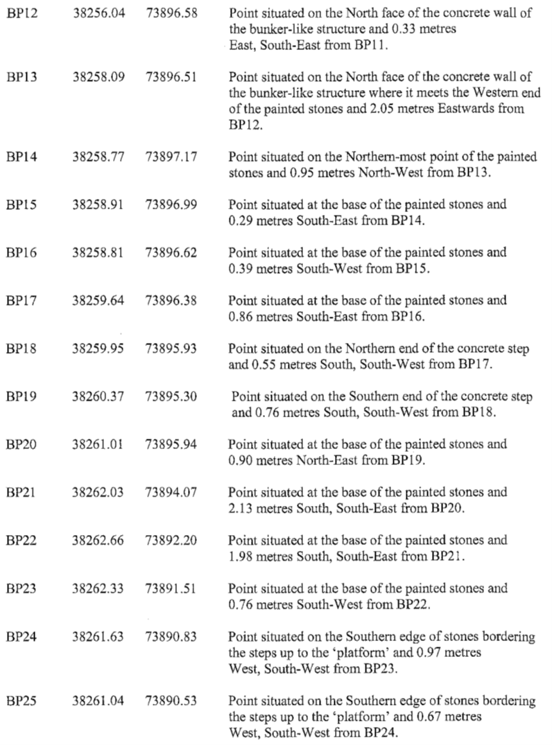
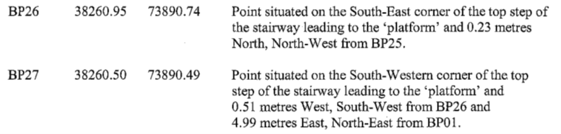
(3) The
boundaries of Sorel Lighthouse towards the land owned by the Public are
constituted by the lines drawn between and joining the co-ordinate points
numbered BP01 to BP27
inclusive as set out on the Co-Ordinate Point Plan dated December 2014 and
as listed in the Co-Ordinate Point Listing both marked M972/03.
(4) Sorel
Lighthouse is transferred subject to and with the benefit of the following
rights and restrictions –
(a) POJL
shall have a right of way at all times and for all purposes over and across the
path or track and asphalt road (the “access ways”) owned by the
Public (but only to such extent as the width of the access ways at the transfer
date may allow) and leading from Sorel Lighthouse to the road known as “La
Route du Nord”, POJL being bound to pay, when called upon to do so, its
fair share of the costs incurred by the Public in respect of the maintenance
and repair of the access ways;
(b) POJL
shall have no right to park or place any vehicles or other objects whatever, whether
temporarily or otherwise, on the access ways except in the course and for the
purpose of delivering materials necessary for the maintenance and repair of
Sorel Lighthouse;
(c) POJL
shall have the right to park and place temporarily a reasonable number of
vehicles and plant in the car park owned by the public, in the course of
necessary maintenance and repair of Sorel Lighthouse.
(5) Sorel
Lighthouse shall only be used as a lighthouse and/or navigation beacon and for
no other purpose.
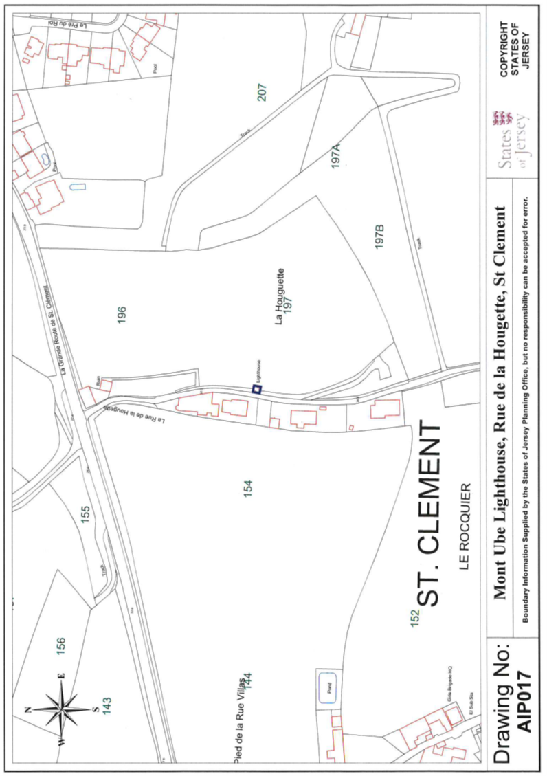
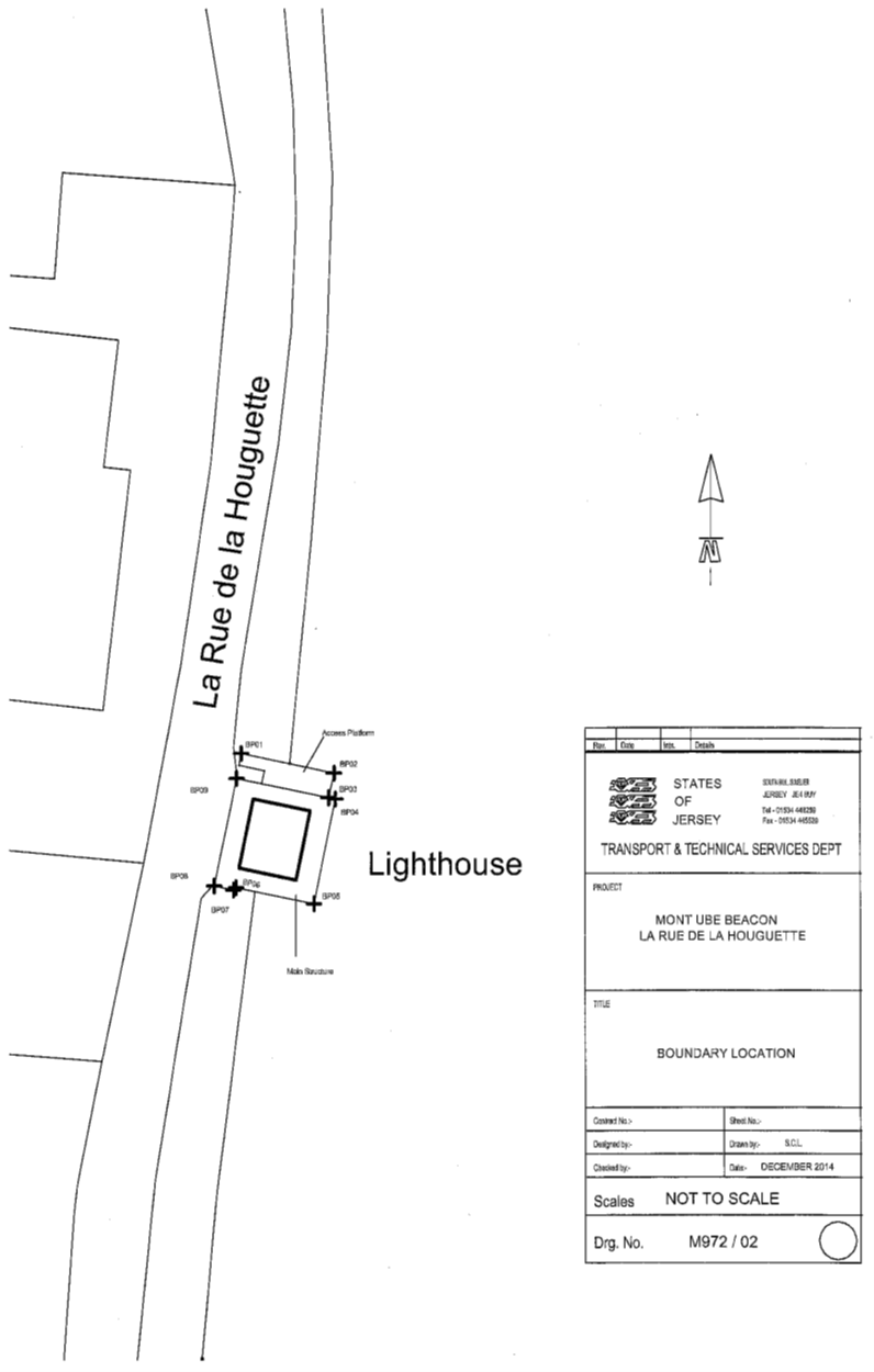
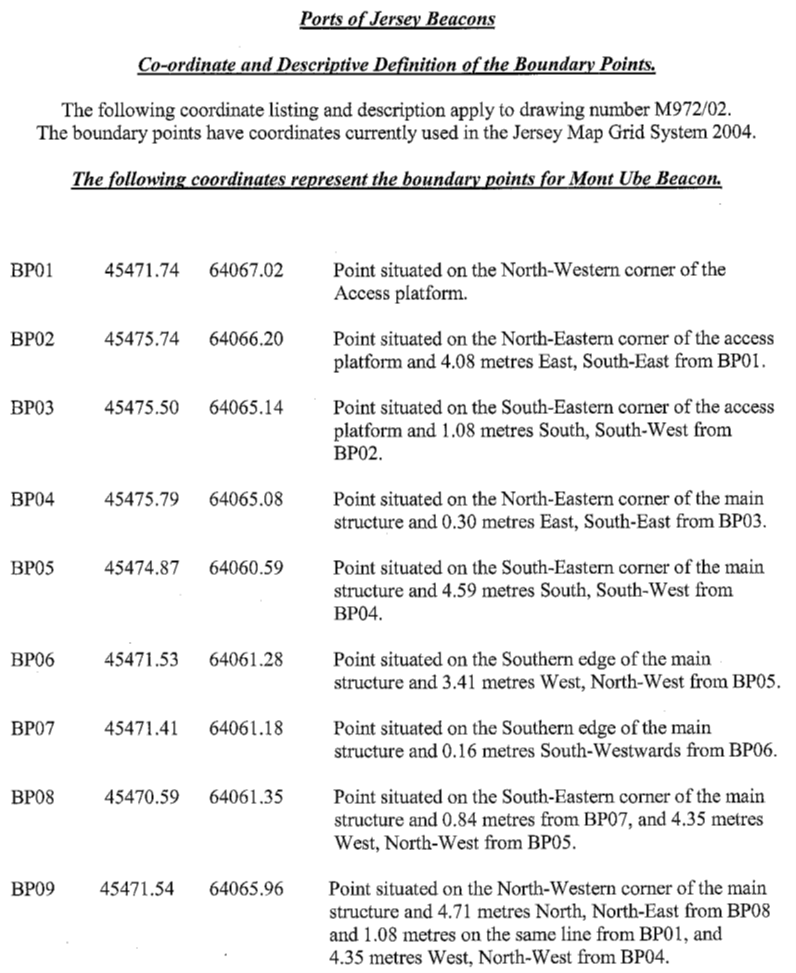
17 Mont Ubé
Lighthouse, La Rue de la Houguette, St. Clement
(1) The
property (“Mont Ubé Lighthouse”) having the UPRN 69205793
and situate in the Vingtaine de la Rocquier in the Parish of St. Clement and
comprising land together with a lighthouse or navigation beacon and associated
apparatus on the land as shown on the plan marked AIP017.
(2) The
boundaries of Mont Ubé Lighthouse are constituted by the lines drawn
between and joining the co-ordinate points numbered BP01
to BP09 inclusive as set out in the Co-Ordinate
Point Plan dated December 2014 and as listed in the Co-Ordinate Point
Listing both marked M972/02.
(3) The
Public is entitled to Mont Ubé Lighthouse by contracts of acquisition
dated 26th October 1895 (PR318/88) and 22nd December 1928
(PR404/156).
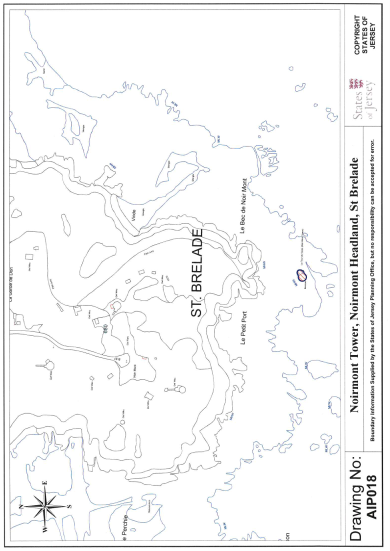
18 Noirmont Tower,
Le Chemin de Noirmont, St. Brelade
(1) The
property (“Noirmont Tower”) having the UPRN 63960021 and situate in
the Vingtaine de Noirmont in the Parish of St. Brelade and comprising a
stone tower navigation beacon and curved walls and appurtenances constructed on
part of a rock as shown on the plan marked AIP018.
(2) The
Public is entitled to Noirmont Tower (and the rock beneath and surrounding it)
by contract of acquisition dated 4th November 1911 (PR358/61).
(3) Noirmont
Tower is transferred subject to and with the benefit of the following rights
and restrictions –
(a) Noirmont
Tower and the curved walls depending from it (towards the rock surrounding
those walls and owned by the Public) shall belong without offset to POJL and
shall remain as they are established at the transfer date;
(b) notwithstanding
that the rock beneath and surrounding Noirmont Tower is owned by the Public,
the Public shall not owe any right of support to Noirmont Tower in “voisinage”
or otherwise;
(c) POJL
shall have a right of way at all times and for all purposes over and across the
asphalt road owned by the Public called “Le Chemin de
Noirmont” as well as over and across the rock faces forming part of
“Noirmont Headland” and owned by the Public to “La Route de
Noirmont”, POJL being bound to pay, when called upon to do so, its fair
share of the costs incurred by the Public in respect of the maintenance and
repair of that part of “Le Chemin de Noirmont” over which POJL
enjoys the right of way;
(d) POJL
shall have no right to park or place any vehicles or other objects whatever,
whether temporarily or otherwise, on “Le Chemin de Noirmont”
or “Noirmont Headland” except in the course and for the purpose of
delivering materials necessary for the maintenance and repair of Noirmont
Tower;
(e) POJL
shall have the right to park and place temporarily a reasonable number of
vehicles and plant in the car park at the southern extremity of
“Le Chemin de Noirmont” and owned by the Public, in the course
of necessary maintenance and repair of Noirmont Tower.
(4) Noirmont
Tower shall only be used as a navigation beacon and for no other purpose.
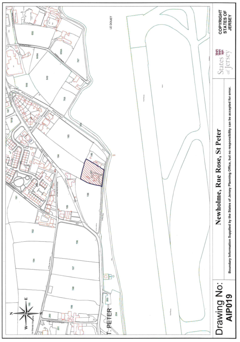
19 Newholme, La Rue
Rose, St. Peter
(1) The
property (“Newholme”) having the UPRN 69120838 and situate in the
Vingtaine du Douet in the Parish of St. Peter and comprising a house garage
outbuildings driveway gardens and their appurtenances as shown on the plan
marked AIP019.
(2) The
Public is entitled to Newholme by contract of acquisition dated 10th April 2015
(PR1348/209).
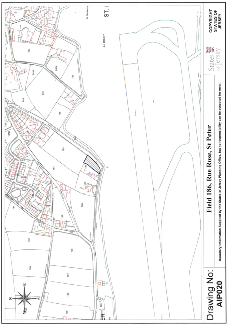
20 Field 186,
La Rue Rose, St. Peter
(1) The
property (“Field 186”) having the UPRN 69201069 and situate in
the Vingtaine du Douet in the Parish of St. Peter and comprising a
rectangular shaped field known as “La Sablonnière” and
its appurtenances as shown on the plan marked AIP020.
(2) The
Public is entitled to Field 186 by contract of acquisition dated
10th April 2015 (PR1348/209).
Part
3
Other
assets transferred
1 All
items that were shown, on 19th June 2015, in the part of the
accounting register of the States of Jersey marked 07100 and relating to Jersey
Harbours, in the following classes –
410 Plant & Equipment and Fixtures & Fittings
510 Transport Equipment
710 Information Technology
720 Information Technology/Software.
2 All
items that were shown, on 19th June 2015, in the part of the
accounting register of the States of Jersey marked 07200 and relating to
Jersey Airport, in the following classes –
410 Plant & Equipment and Fixtures & Fittings
440 Other Structures
510 Transport Equipment
710 Information Technology
720 Information Technology/Software.